Total solar eclipse of 05/23/2859
| Day of week: | Friday |
| Maximum duration of eclipse: | 02m58s |
| Maximum width of eclipse path: | 103 km |
| Saros cycle: | 161 |
| Coverage: | 100% |
| Magnitude: | 1.0305 |
| Gamma: | -0.0467 |
Wo kann man die Sonnenfinsternis vom 05/23/2859 sehen?
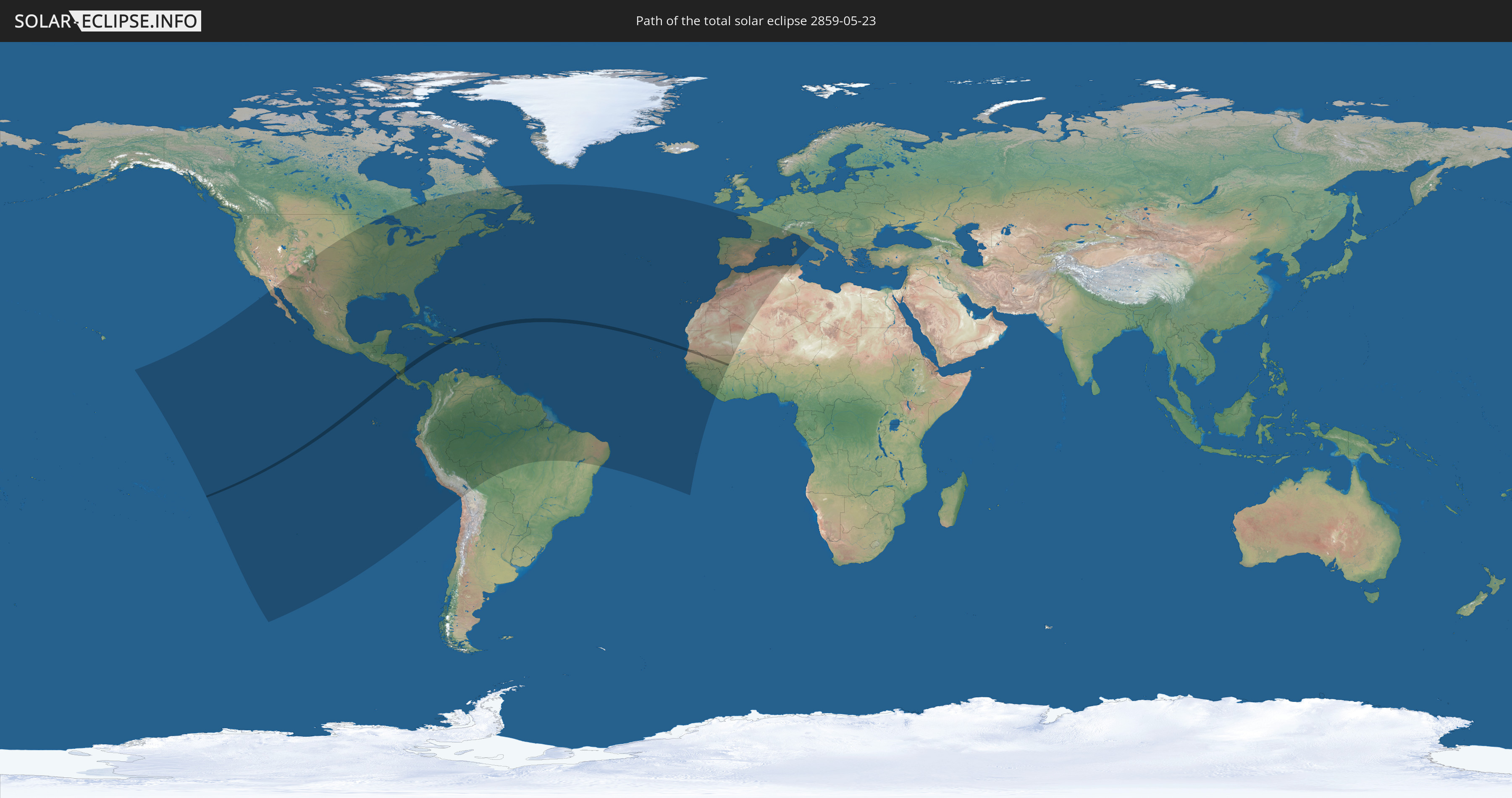
Die Sonnenfinsternis am 05/23/2859 kann man in 71 Ländern als partielle Sonnenfinsternis beobachten.
Der Finsternispfad verläuft durch 9 Länder. Nur in diesen Ländern ist sie als total Sonnenfinsternis zu sehen.
In den folgenden Ländern ist die Sonnenfinsternis total zu sehen
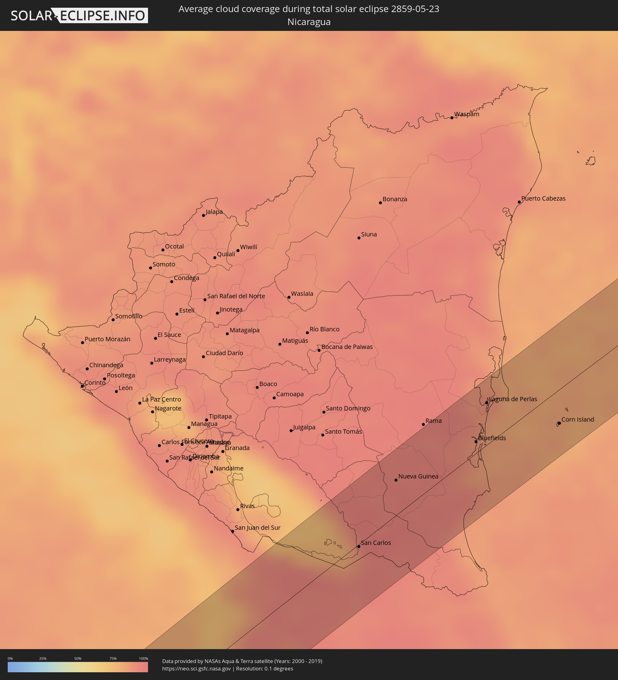
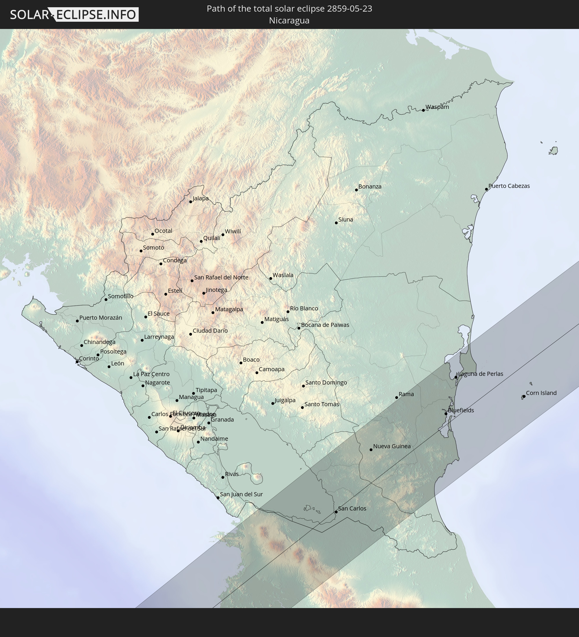 Nicaragua
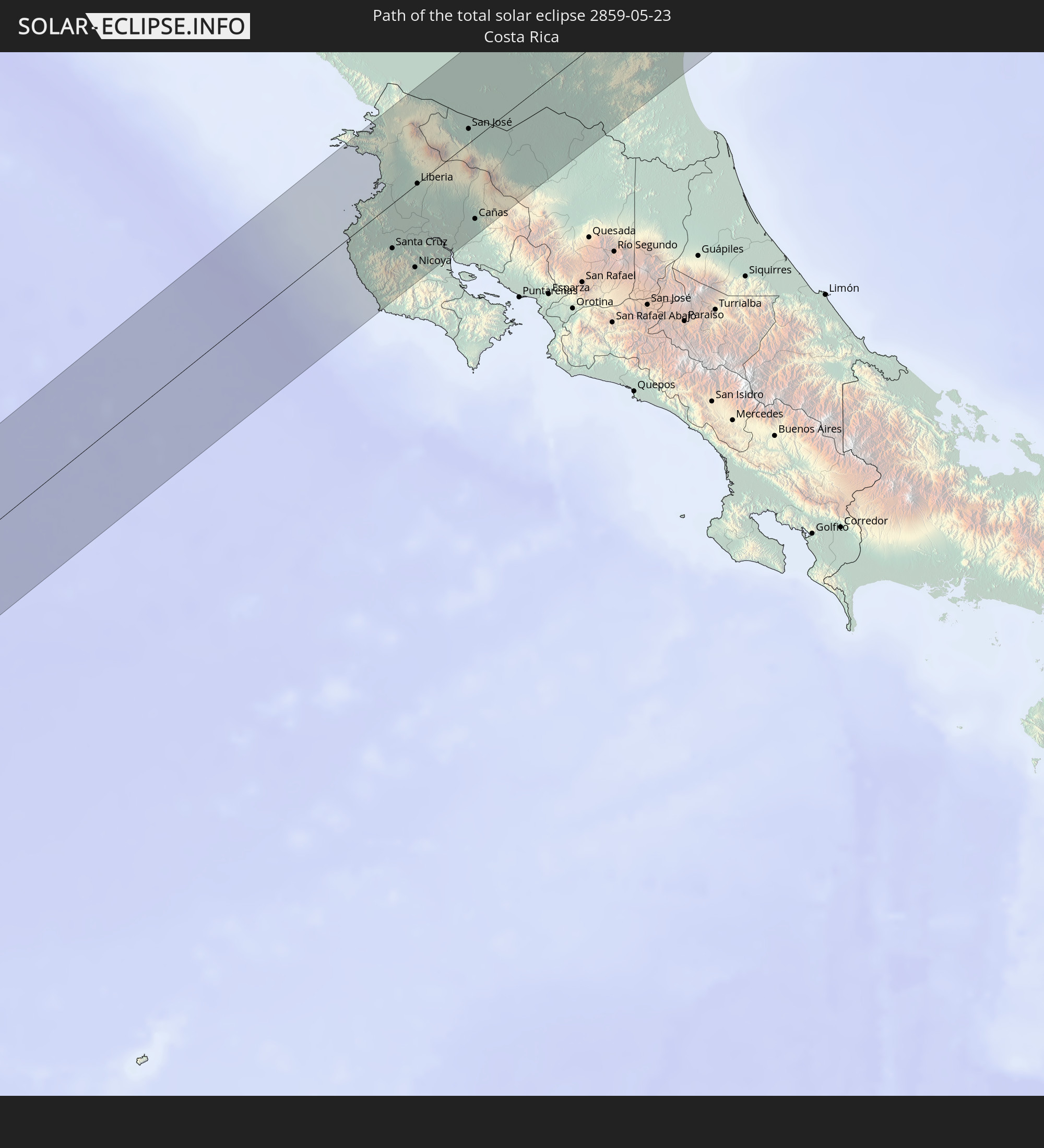 Costa Rica
 Colombia
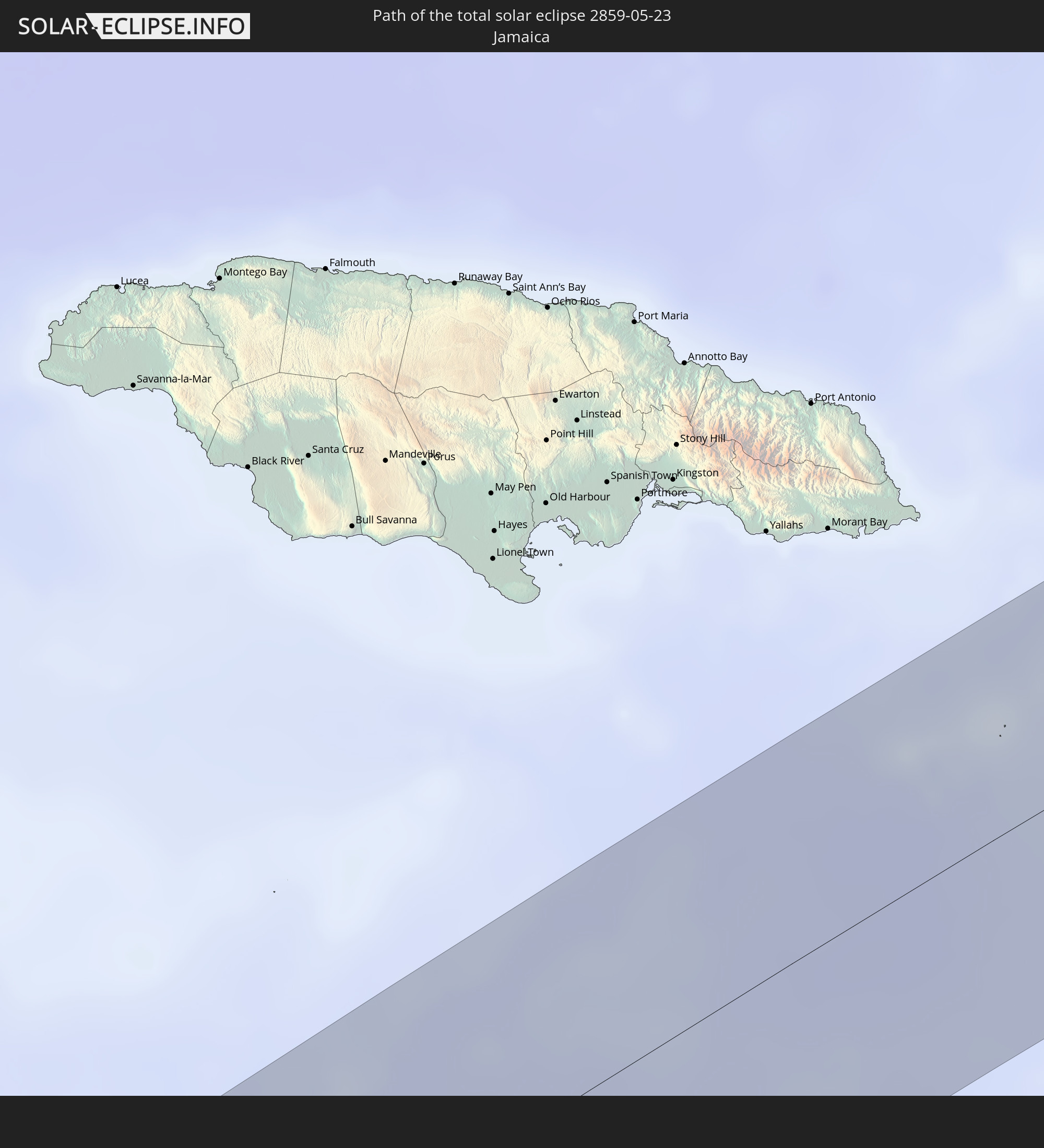 Jamaica
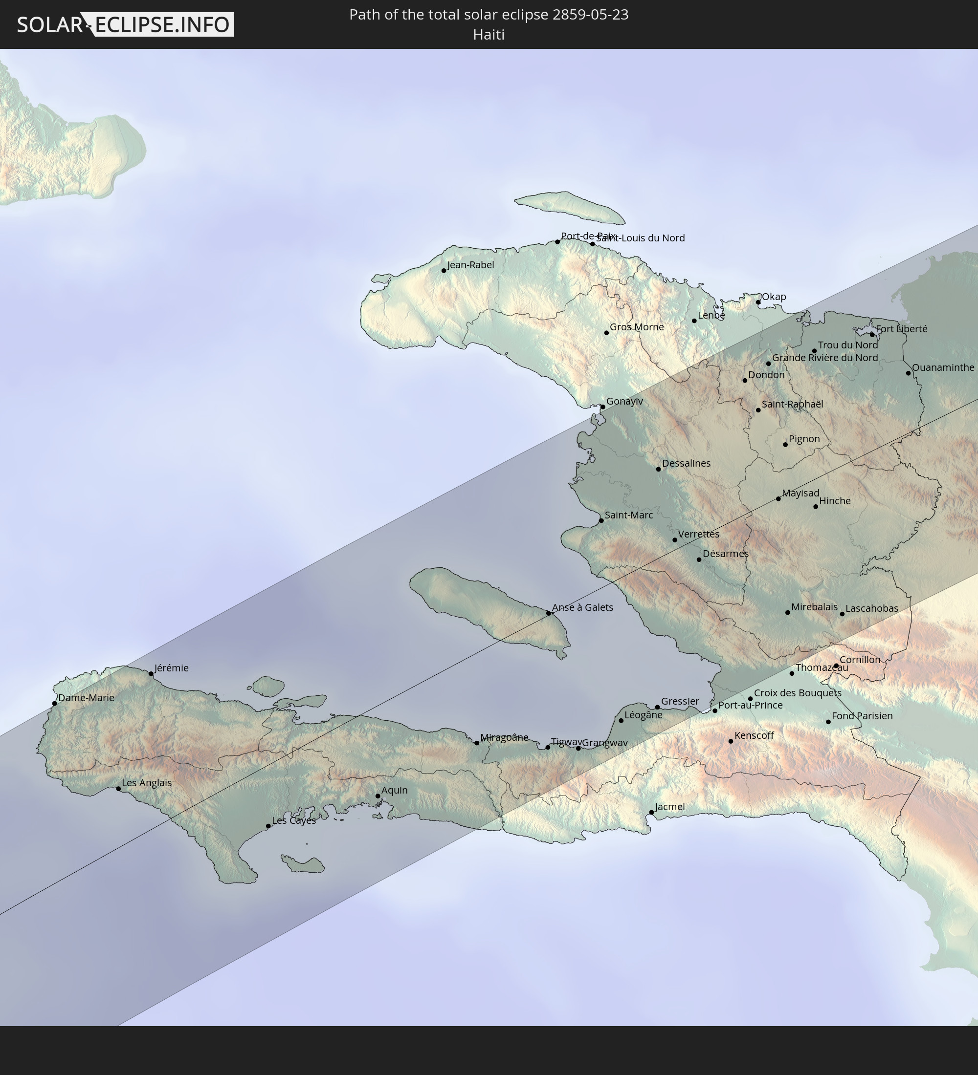 Haiti
Haiti
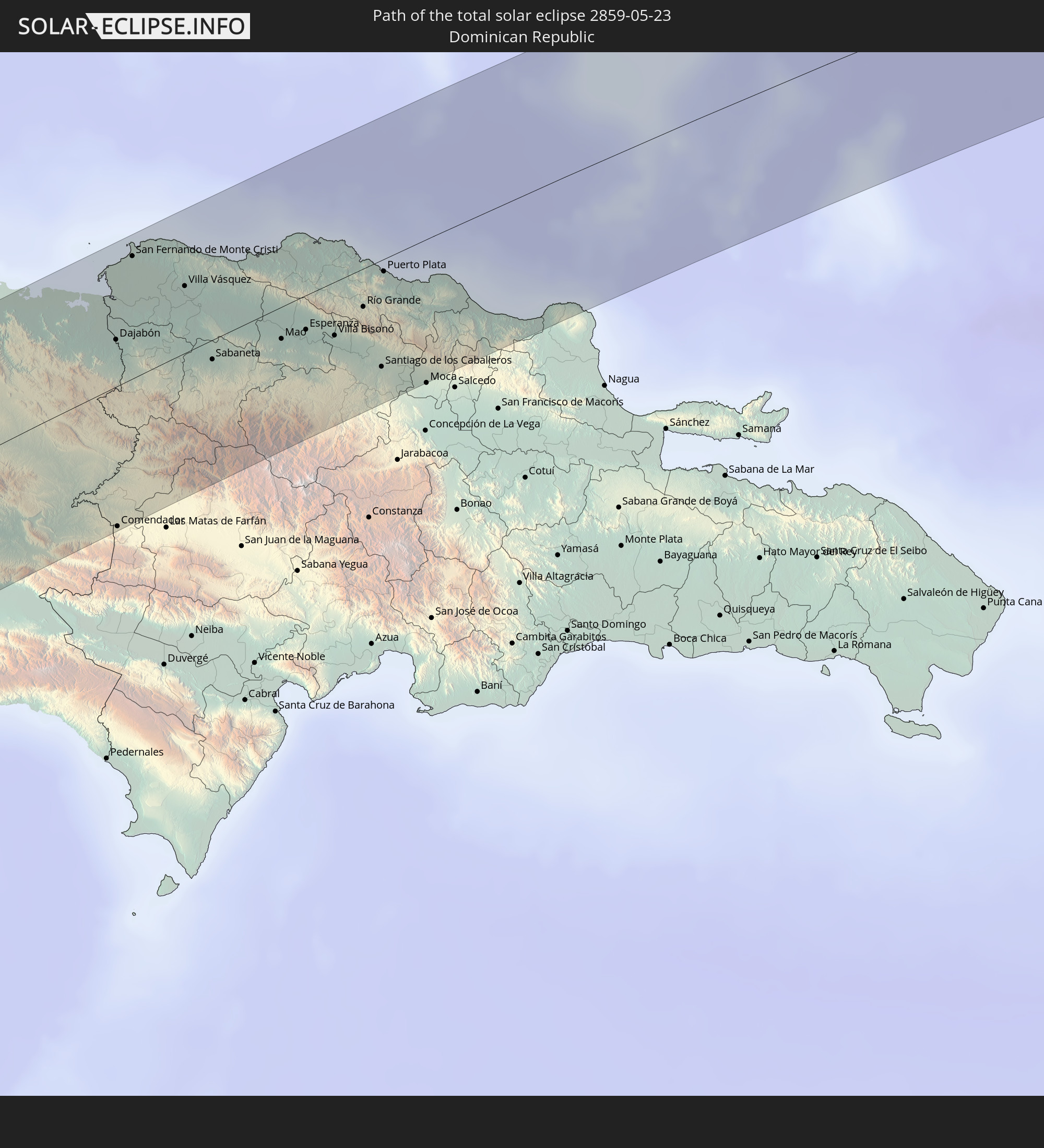 Dominican Republic
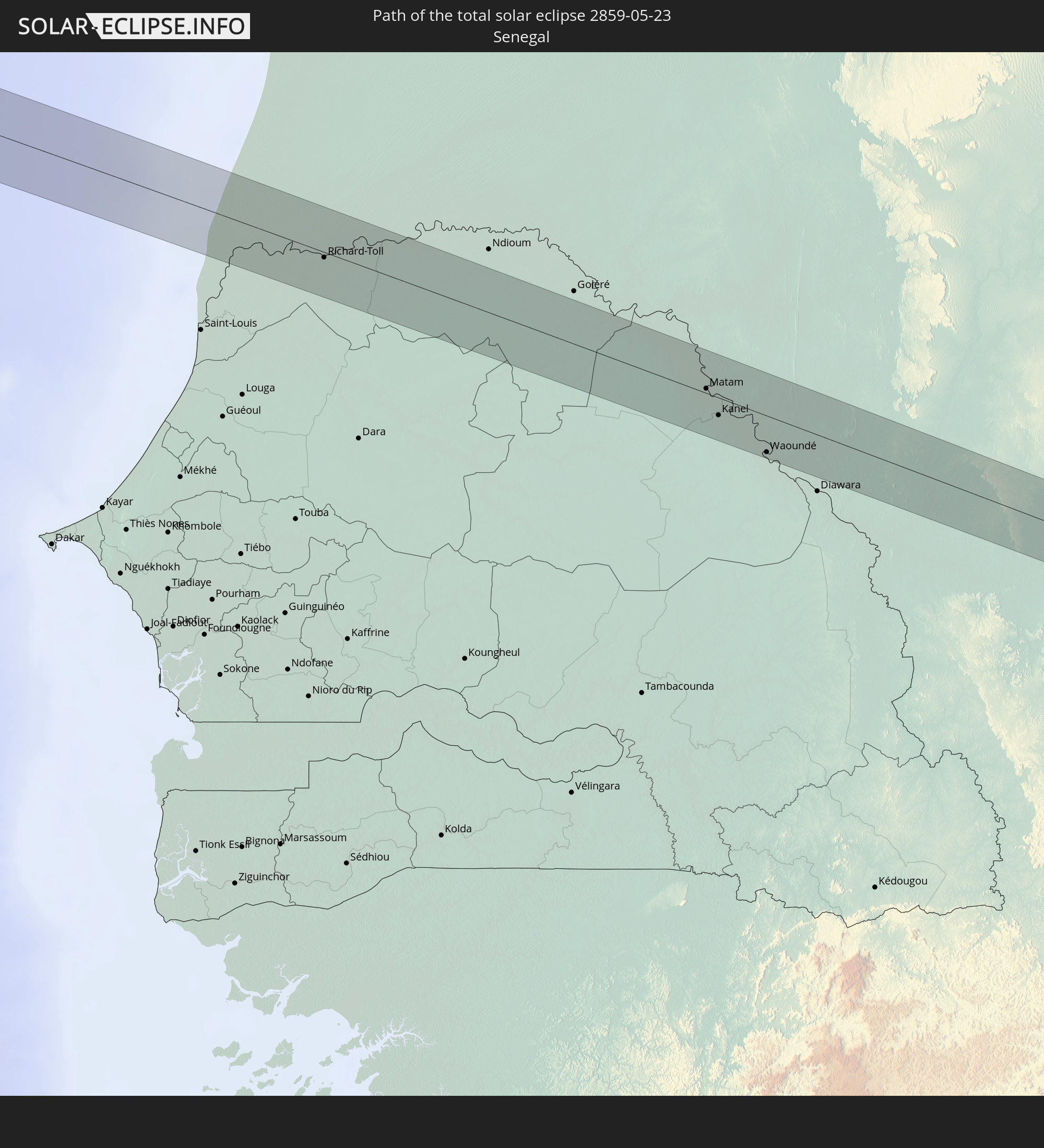 Senegal
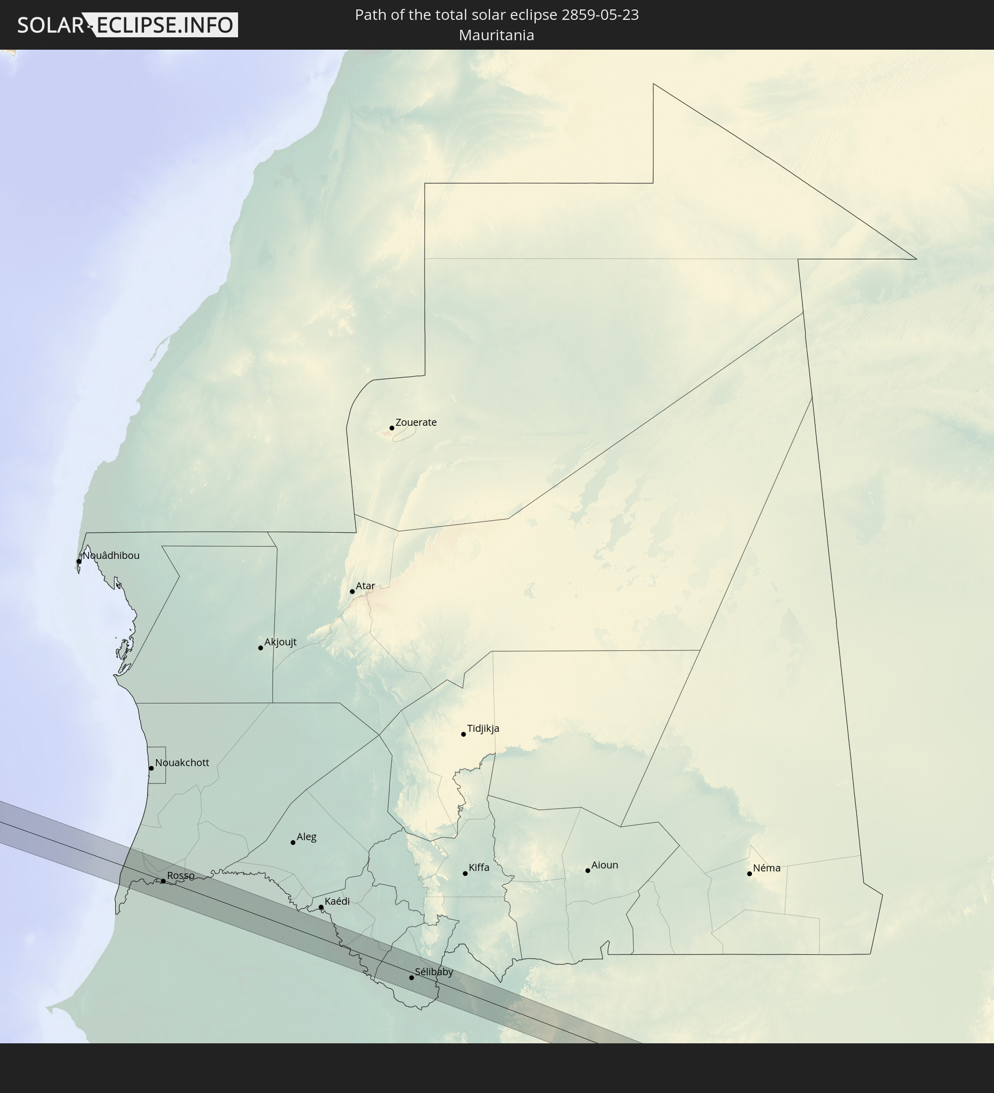 Mauritania
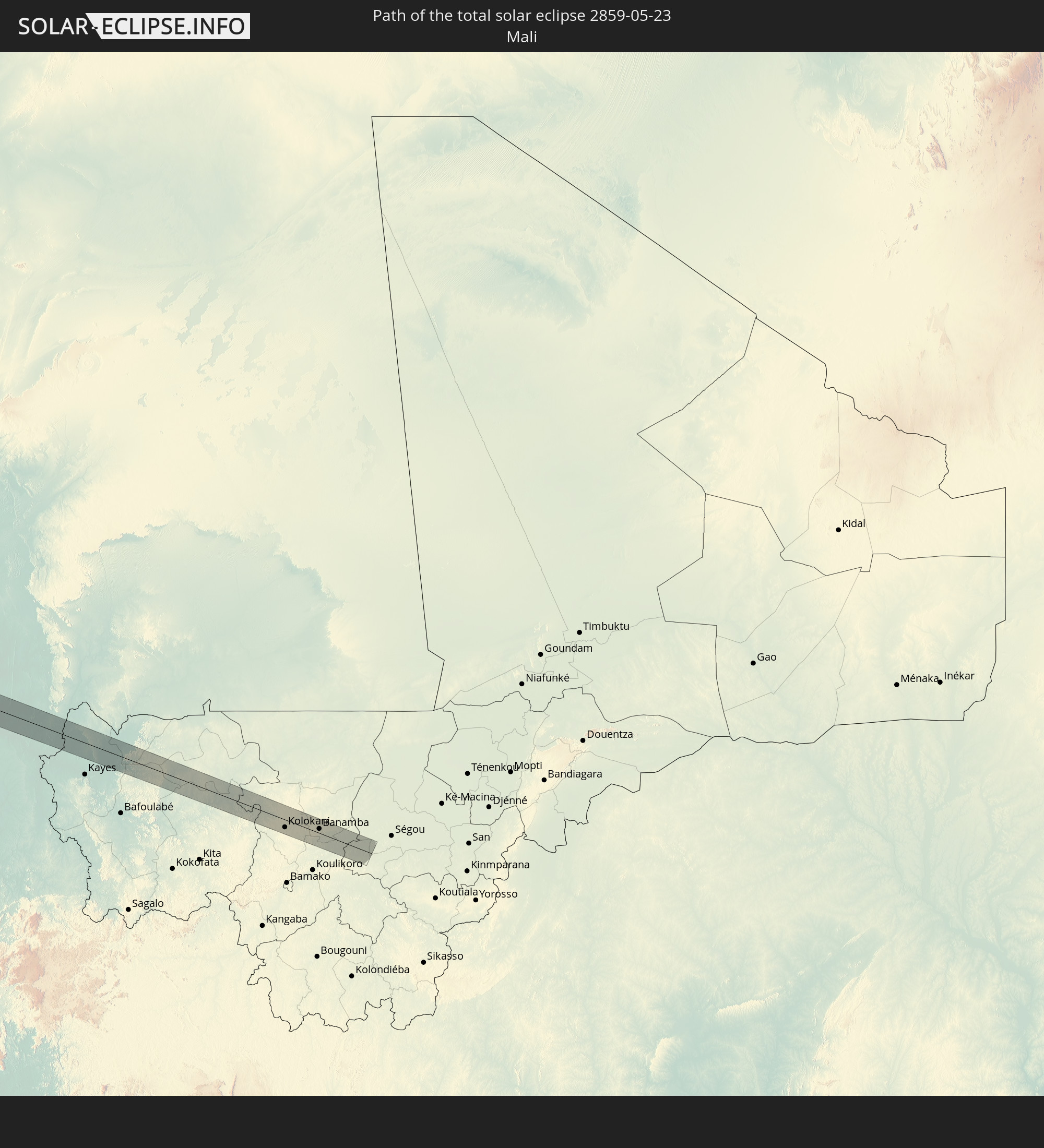 Mali
Mali
In den folgenden Ländern ist die Sonnenfinsternis partiell zu sehen
 United States
 United States Minor Outlying Islands
 Canada
 Pitcairn Islands
 Mexico
 Chile
Chile
 Guatemala
 Ecuador
 El Salvador
 Honduras
 Belize
 Nicaragua
 Costa Rica
 Cuba
Cuba
 Panama
 Colombia
 Cayman Islands
 Peru
Peru
 The Bahamas
 Jamaica
 Haiti
Haiti
 Brazil
 Venezuela
 Turks and Caicos Islands
 Dominican Republic
 Aruba
Aruba
 Bolivia
 Puerto Rico
 United States Virgin Islands
 Bermuda
 British Virgin Islands
 Anguilla
 Collectivity of Saint Martin
 Saint Barthélemy
 Saint Kitts and Nevis
 Antigua and Barbuda
 Montserrat
 Trinidad and Tobago
 Guadeloupe
 Grenada
 Dominica
 Saint Vincent and the Grenadines
 Guyana
 Martinique
 Saint Lucia
 Barbados
 Suriname
 Saint Pierre and Miquelon
 French Guiana
 Portugal
 Cabo Verde
 Spain
Spain
 Senegal
 Mauritania
 The Gambia
 Guinea-Bissau
 Guinea
 Saint Helena, Ascension and Tristan da Cunha
 Sierra Leone
 Morocco
 Mali
Mali
 Liberia
 Algeria
 Ivory Coast
 Gibraltar
 France
 Andorra
 Italy
Italy
 Monaco
 Tunisia
 Vatican City
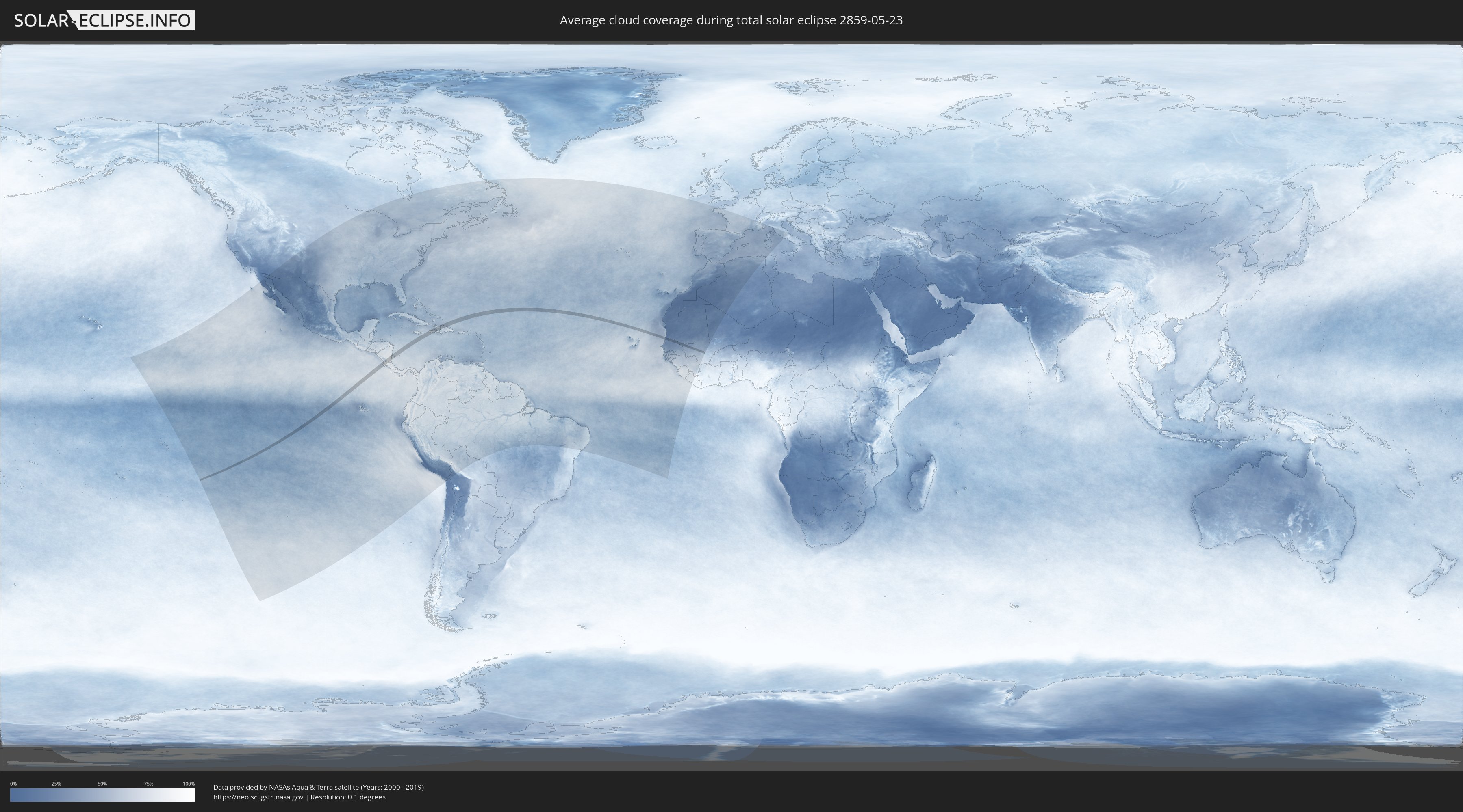
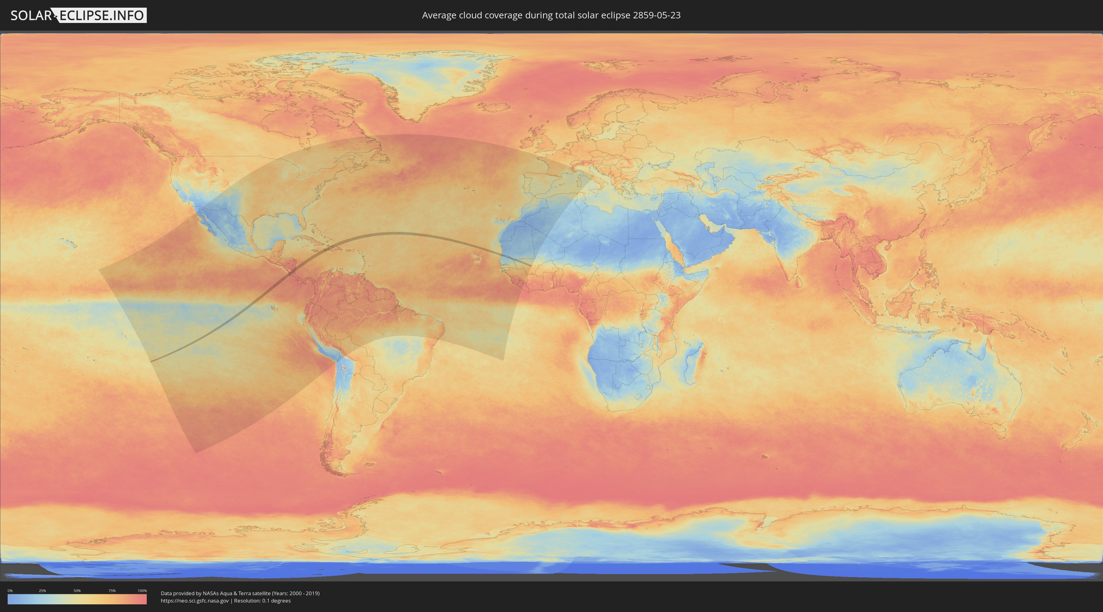
How will be the weather during the total solar eclipse on 05/23/2859?
Where is the best place to see the total solar eclipse of 05/23/2859?
The following maps show the average cloud coverage for the day of the total solar eclipse.
With the help of these maps, it is possible to find the place along the eclipse path, which has the best
chance of a cloudless sky.
Nevertheless, you should consider local circumstances and inform about the weather of your chosen
observation site.
The data is provided by NASAs satellites
AQUA and TERRA.
The cloud maps are averaged over a period of 19 years (2000 - 2019).
Detailed country maps
 Nicaragua
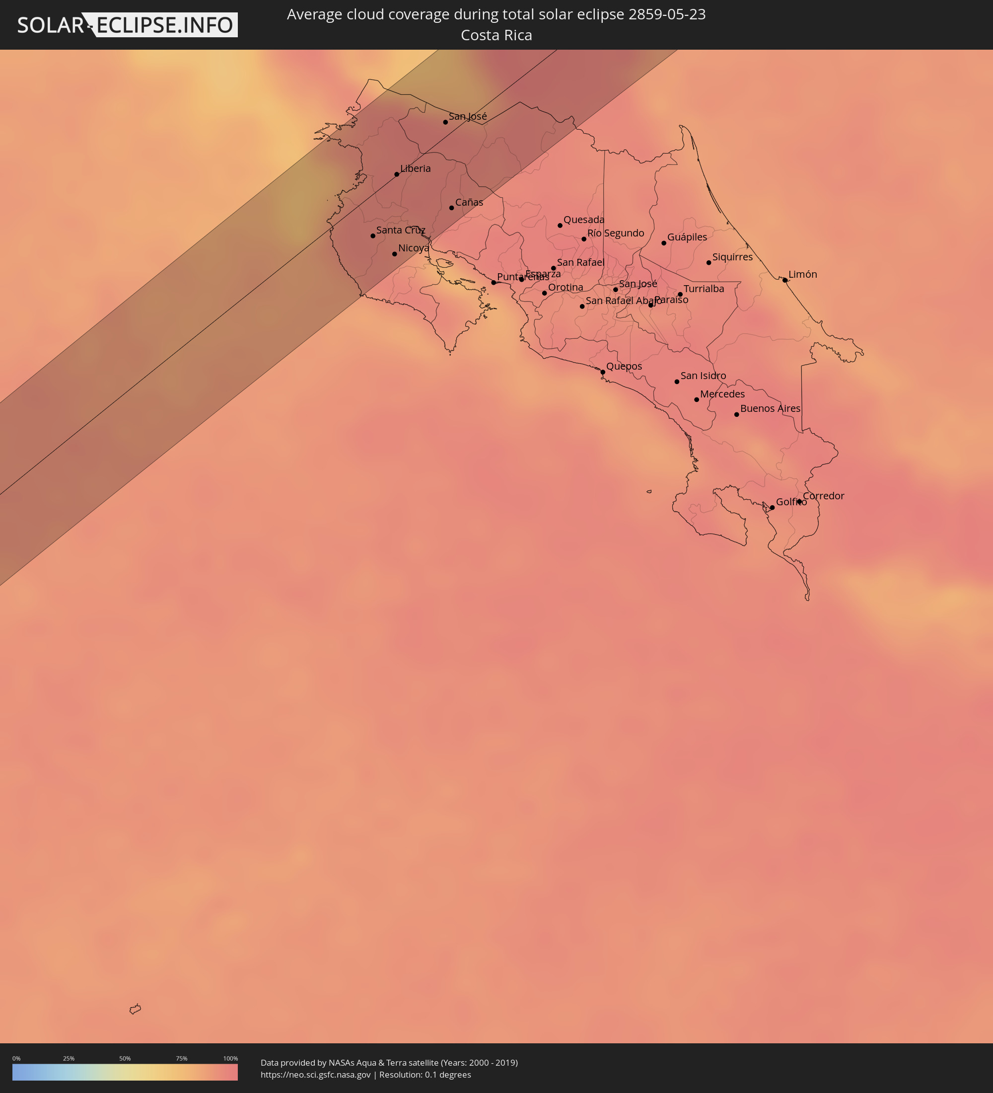 Costa Rica
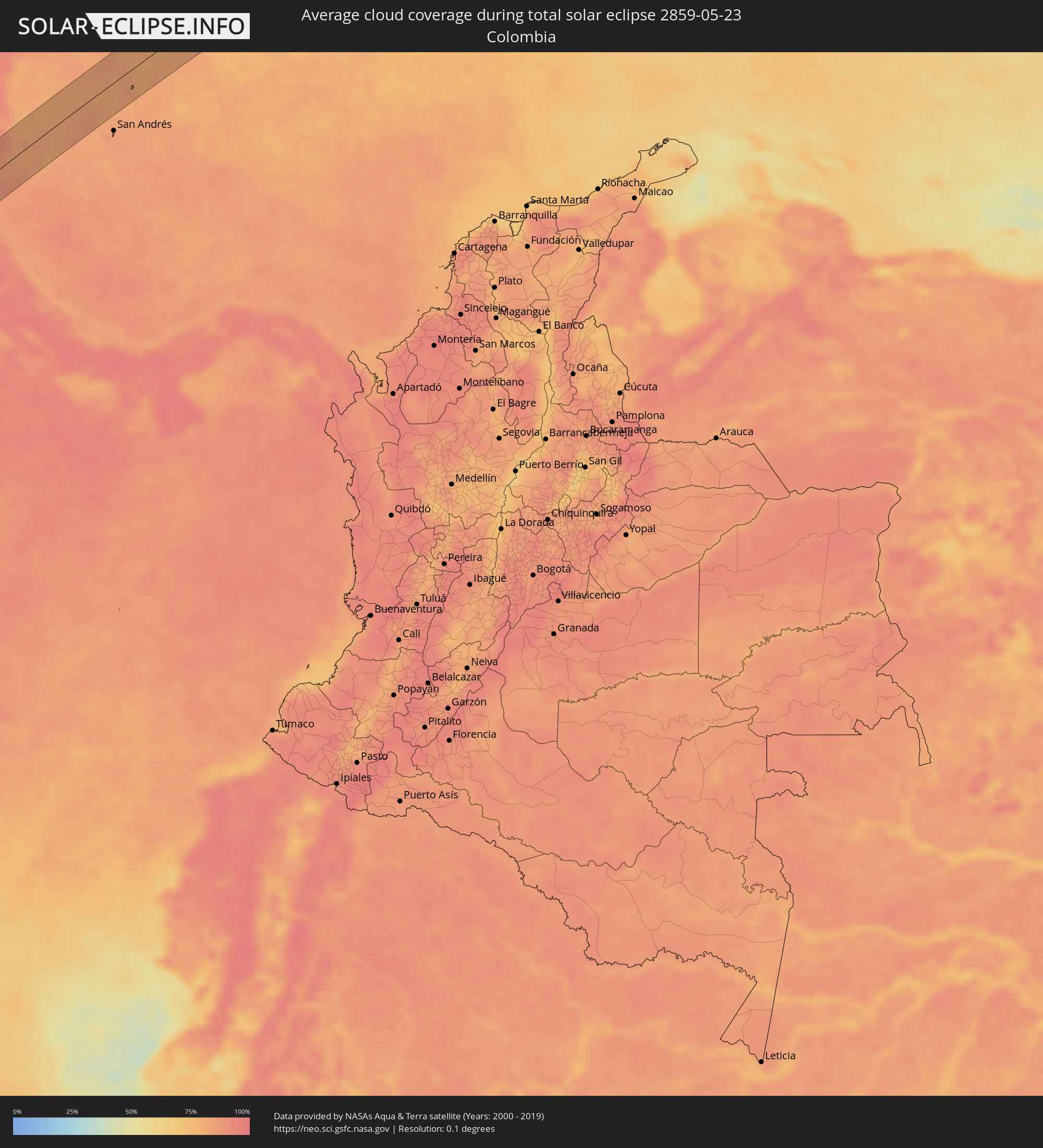 Colombia
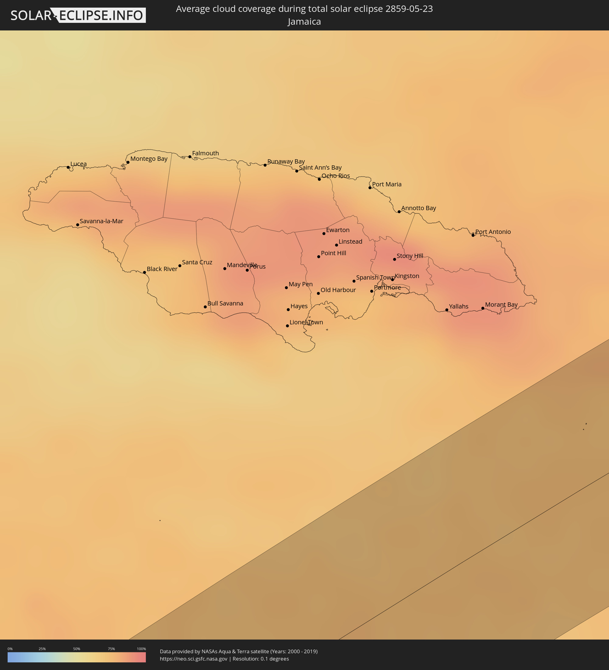 Jamaica
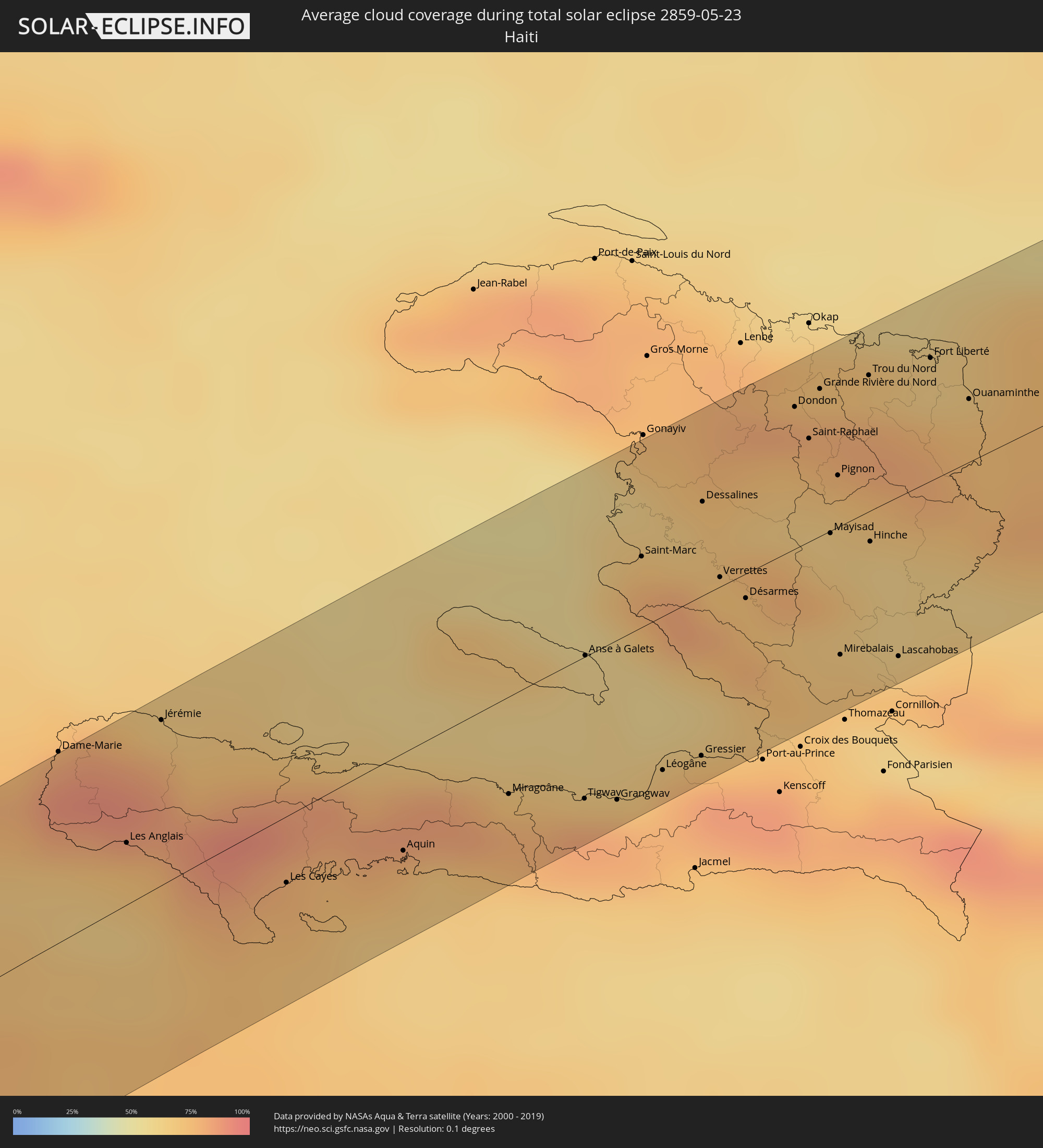 Haiti
Haiti
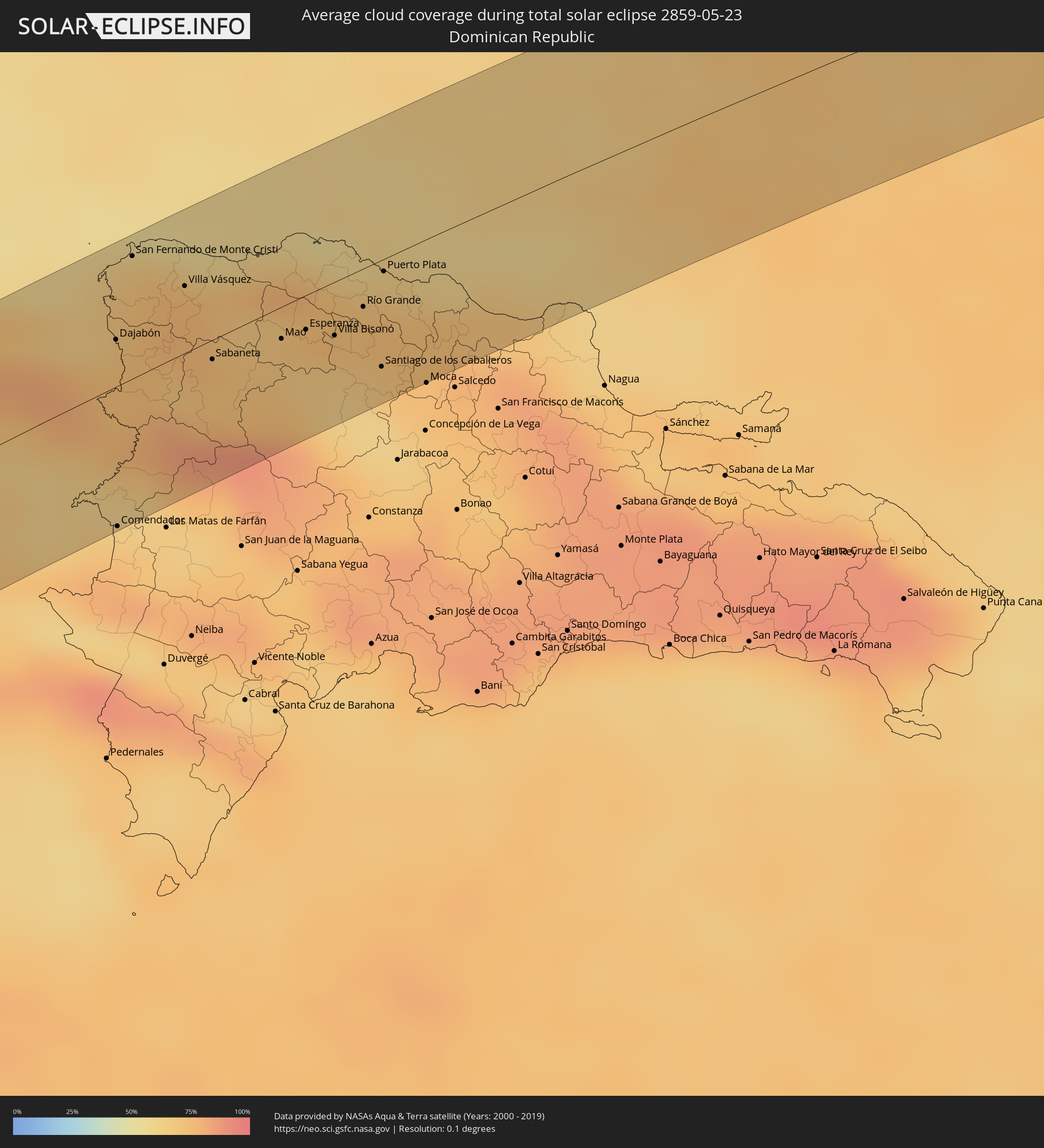 Dominican Republic
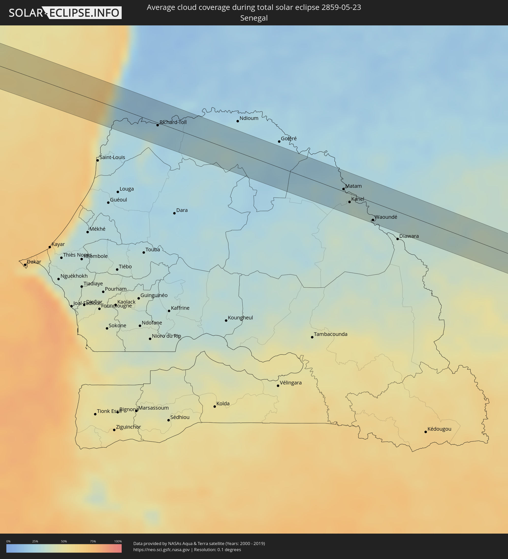 Senegal
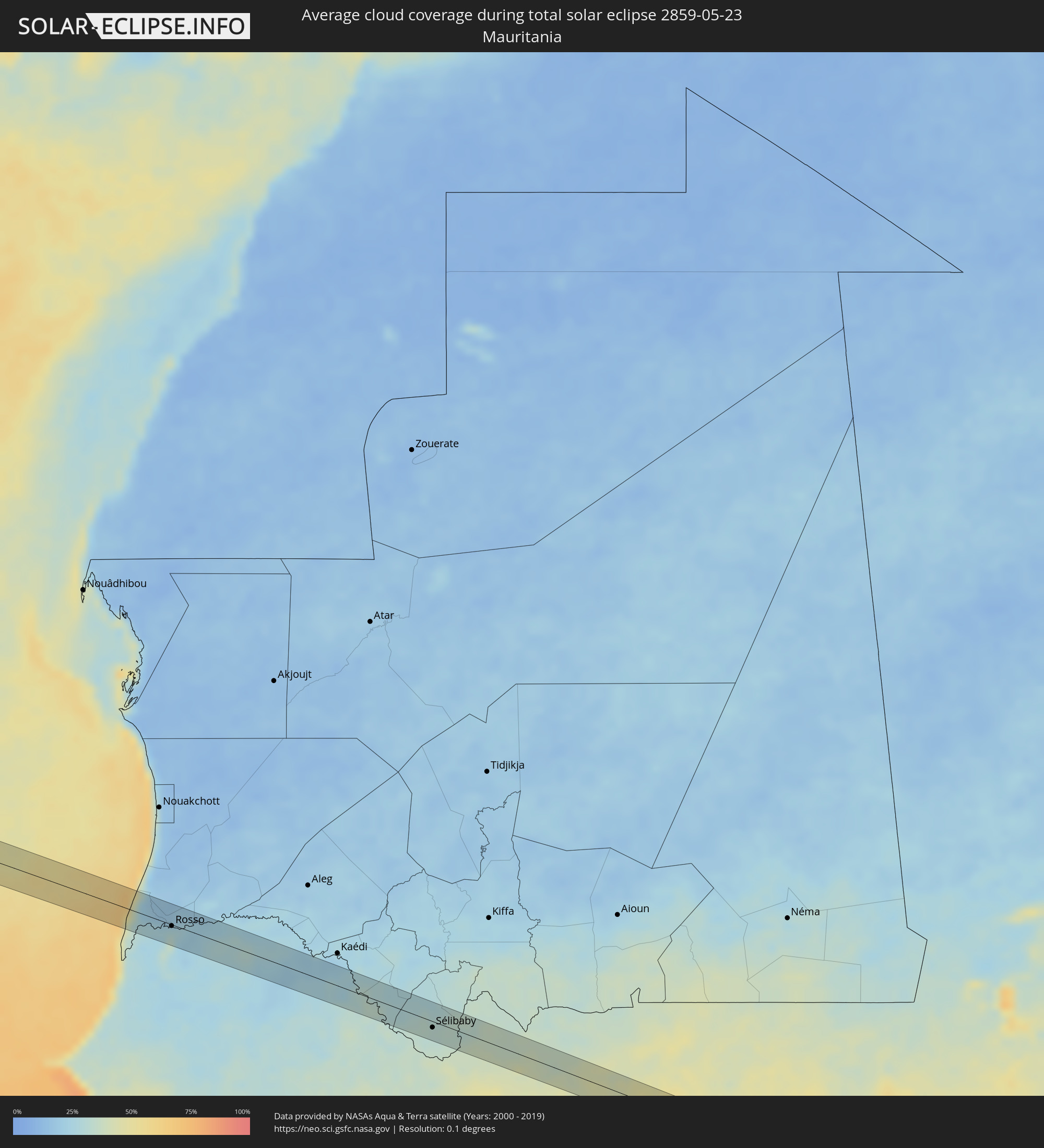 Mauritania
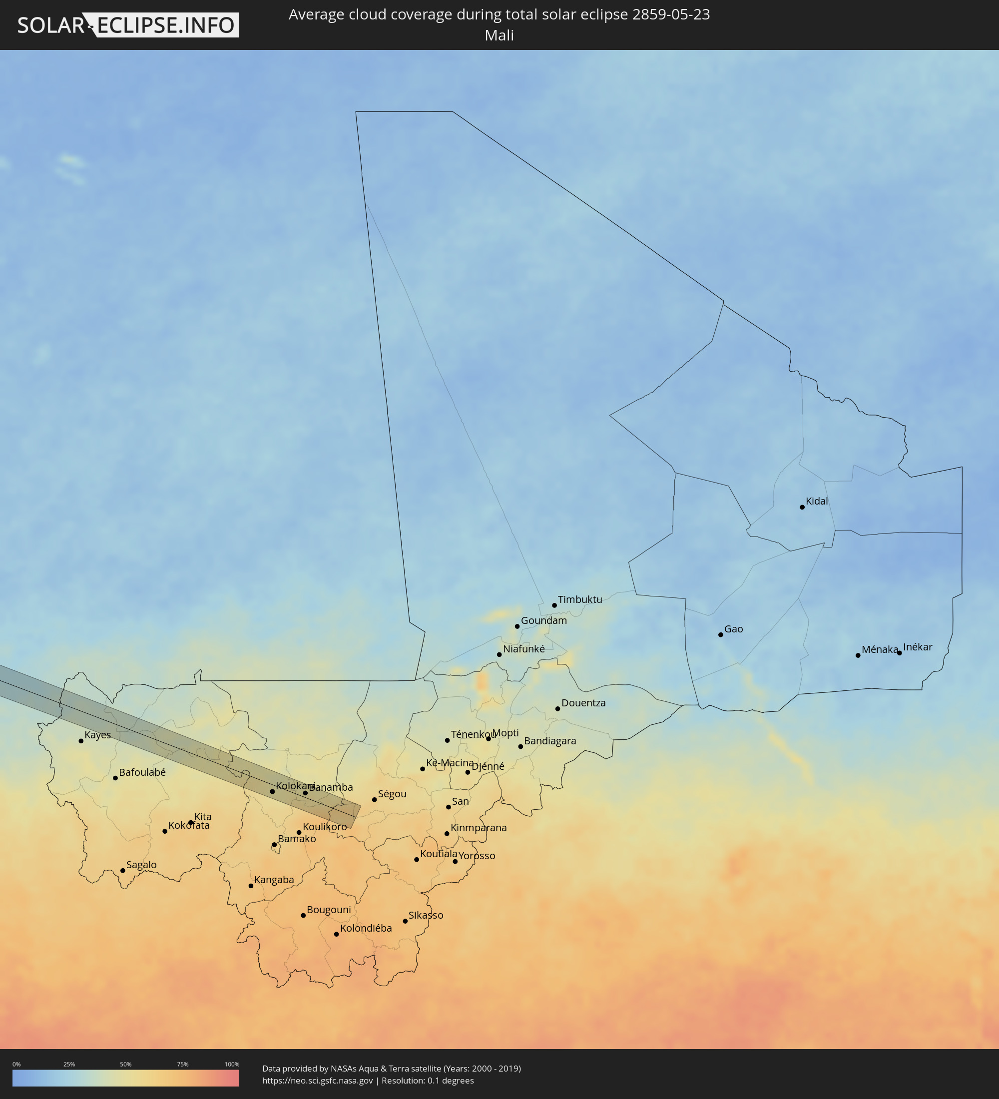 Mali
Mali
Cities inside the path of the eclipse
The following table shows all locations with a population of more than 5,000 inside the eclipse path. Cities which have more than 100,000 inhabitants are marked bold. A click at the locations opens a detailed map.
| City | Type | Eclipse duration | Local time of max. eclipse | Distance to central line | Ø Cloud coverage |
|
Santa Cruz, Guanacaste
|
total | - | 10:15:58 UTC-06:00 | 23 km | 94% |
|
Nicoya, Guanacaste
|
total | - | 10:16:04 UTC-06:00 | 41 km | 93% |
|
Liberia, Guanacaste
|
total | - | 10:16:56 UTC-06:00 | 0 km | 94% |
|
San José, Alajuela
|
total | - | 10:18:07 UTC-06:00 | 7 km | 96% |
|
Cañas, Guanacaste
|
total | - | 10:17:17 UTC-06:00 | 41 km | 95% |
|
Tilarán, Guanacaste
|
total | - | 10:17:38 UTC-06:00 | 47 km | 94% |
|
San Carlos, Río San Juan
|
total | - | 10:19:11 UTC-06:00 | 2 km | 91% |
|
Nueva Guinea, Atlántico Sur
|
total | - | 10:20:52 UTC-06:00 | 26 km | 95% |
|
Bluefields, Atlántico Sur
|
total | - | 10:22:56 UTC-06:00 | 8 km | 88% |
|
Laguna de Perlas, Atlántico Sur
|
total | - | 10:23:43 UTC-06:00 | 31 km | 86% |
|
Corn Island, Atlántico Sur
|
total | - | 10:24:49 UTC-06:00 | 26 km | 82% |
|
Les Anglais, Sud
|
total | - | 11:57:01 UTC-05:00 | 17 km | 73% |
|
Jérémie, GrandʼAnse
|
total | - | 11:57:49 UTC-05:00 | 45 km | 69% |
|
Les Cayes, Sud
|
total | - | 11:58:06 UTC-05:00 | 18 km | 76% |
|
Aquin, Sud
|
total | - | 11:59:10 UTC-05:00 | 27 km | 76% |
|
Miragoâne, Nippes
|
total | - | 12:00:15 UTC-05:00 | 27 km | 79% |
|
Tigwav, Ouest
|
total | - | 12:00:50 UTC-05:00 | 39 km | 82% |
|
Anse à Galets, Ouest
|
total | - | 12:01:26 UTC-05:00 | 0 km | 60% |
|
Grangwav, Ouest
|
total | - | 12:01:05 UTC-05:00 | 44 km | 82% |
|
Saint-Marc, Artibonite
|
total | - | 12:02:17 UTC-05:00 | 20 km | 78% |
|
Léogâne, Ouest
|
total | - | 12:01:34 UTC-05:00 | 43 km | 79% |
|
Gressier, Ouest
|
total | - | 12:01:57 UTC-05:00 | 44 km | 74% |
|
Dessalines, Artibonite
|
total | - | 12:02:59 UTC-05:00 | 26 km | 70% |
|
Verrettes, Artibonite
|
total | - | 12:02:49 UTC-05:00 | 3 km | 73% |
|
Carrefour, Ouest
|
total | - | 12:02:15 UTC-05:00 | 51 km | 85% |
|
Désarmes, Artibonite
|
total | - | 12:02:56 UTC-05:00 | 7 km | 73% |
|
Dondon, Nord
|
total | - | 12:04:06 UTC-05:00 | 39 km | 76% |
|
Milot, Nord
|
total | - | 12:04:17 UTC-05:00 | 46 km | 79% |
|
Saint-Raphaël, Nord
|
total | - | 12:04:05 UTC-05:00 | 29 km | 69% |
|
Grande Rivière du Nord, Nord
|
total | - | 12:04:22 UTC-05:00 | 41 km | 79% |
|
Mayisad, Centre
|
total | - | 12:03:53 UTC-05:00 | 1 km | 64% |
|
Pignon, Nord
|
total | - | 12:04:10 UTC-05:00 | 14 km | 66% |
|
Mirebalais, Centre
|
total | - | 12:03:28 UTC-05:00 | 36 km | 71% |
|
Trou du Nord, Nord-Est
|
total | - | 12:04:49 UTC-05:00 | 38 km | 79% |
|
Hinche, Centre
|
total | - | 12:04:10 UTC-05:00 | 9 km | 62% |
|
Lascahobas, Centre
|
total | - | 12:03:56 UTC-05:00 | 44 km | 76% |
|
Fort Liberté, Nord-Est
|
total | - | 12:05:22 UTC-05:00 | 34 km | 65% |
|
Ouanaminthe, Nord-Est
|
total | - | 12:05:31 UTC-05:00 | 18 km | 73% |
|
Dajabón, Dajabón
|
total | - | 13:05:34 UTC-04:00 | 17 km | 73% |
|
Comendador, Elías Piña
|
total | - | 13:04:38 UTC-04:00 | 50 km | 71% |
|
San Fernando de Monte Cristi, Monte Cristi
|
total | - | 13:06:09 UTC-04:00 | 44 km | 73% |
|
Loma de Cabrera, Dajabón
|
total | - | 13:05:41 UTC-04:00 | 0 km | 76% |
|
Las Matas de Santa Cruz, Monte Cristi
|
total | - | 13:06:17 UTC-04:00 | 20 km | 76% |
|
Villa Vásquez, Monte Cristi
|
total | - | 13:06:32 UTC-04:00 | 24 km | 75% |
|
Sabaneta, Santiago Rodríguez
|
total | - | 13:06:27 UTC-04:00 | 7 km | 72% |
|
Monción, Santiago Rodríguez
|
total | - | 13:06:52 UTC-04:00 | 22 km | 75% |
|
Laguna Salada, Valverde
|
total | - | 13:07:23 UTC-04:00 | 1 km | 69% |
|
Mao, Valverde
|
total | - | 13:07:16 UTC-04:00 | 12 km | 70% |
|
Esperanza, Valverde
|
total | - | 13:07:34 UTC-04:00 | 12 km | 67% |
|
San José de Las Matas, Santiago
|
total | - | 13:07:22 UTC-04:00 | 39 km | 73% |
|
Villa Bisonó, Santiago
|
total | - | 13:07:50 UTC-04:00 | 19 km | 67% |
|
Imbert, Puerto Plata
|
total | - | 13:08:13 UTC-04:00 | 2 km | 69% |
|
Villa González, Santiago
|
total | - | 13:08:02 UTC-04:00 | 26 km | 64% |
|
Río Grande, Puerto Plata
|
total | - | 13:08:16 UTC-04:00 | 14 km | 72% |
|
Sabana Iglesia, Santiago
|
total | - | 13:07:49 UTC-04:00 | 49 km | 66% |
|
Santiago de los Caballeros, Santiago
|
total | - | 13:08:10 UTC-04:00 | 39 km | 68% |
|
Puerto Plata, Puerto Plata
|
total | - | 13:08:39 UTC-04:00 | 5 km | 67% |
|
Tamboril, Santiago
|
total | - | 13:08:27 UTC-04:00 | 39 km | 72% |
|
Licey al Medio, Santiago
|
total | - | 13:08:25 UTC-04:00 | 45 km | 67% |
|
San Víctor Arriba, Espaillat
|
total | - | 13:08:39 UTC-04:00 | 43 km | 74% |
|
Veragua Arriba, Espaillat
|
total | - | 13:09:21 UTC-04:00 | 41 km | 78% |
|
Gaspar Hernández, Espaillat
|
total | - | 13:09:33 UTC-04:00 | 39 km | 78% |
|
Río San Juan, María Trinidad Sánchez
|
total | - | 13:10:08 UTC-04:00 | 46 km | 77% |
|
Rosso, Trarza
|
total | - | 18:43:05 UTC+00:00 | 2 km | 28% |
|
Rosso, Saint-Louis
|
total | - | 18:43:07 UTC+00:00 | 11 km | 33% |
|
Richard-Toll, Saint-Louis
|
total | - | 18:43:08 UTC+00:00 | 3 km | 27% |
|
Tékane, Trarza
|
total | - | 18:43:09 UTC+00:00 | 17 km | 24% |
|
Ouro Sogui, Matam
|
total | - | 18:43:51 UTC+00:00 | 5 km | 30% |
|
Matam, Matam
|
total | - | 18:43:51 UTC+00:00 | 3 km | 29% |
|
Kanel, Matam
|
total | - | 18:43:54 UTC+00:00 | 11 km | 31% |
|
Waoundé, Matam
|
total | - | 18:44:01 UTC+00:00 | 23 km | 34% |
|
Sélibaby, Guidimaka
|
total | - | 18:44:07 UTC+00:00 | 9 km | 32% |
|
Kolokani, Koulikoro
|
total | - | 18:44:40 UTC+00:00 | 13 km | 51% |
|
Banamba, Koulikoro
|
total | - | 18:44:39 UTC+00:00 | 7 km | 54% |