Annular solar eclipse of 04/18/0497
| Day of week: | Thursday |
| Maximum duration of eclipse: | 01m18s |
| Maximum width of eclipse path: | 45 km |
| Saros cycle: | 85 |
| Coverage: | 98.7% |
| Magnitude: | 0.9873 |
| Gamma: | 0.0554 |
Wo kann man die Sonnenfinsternis vom 04/18/0497 sehen?
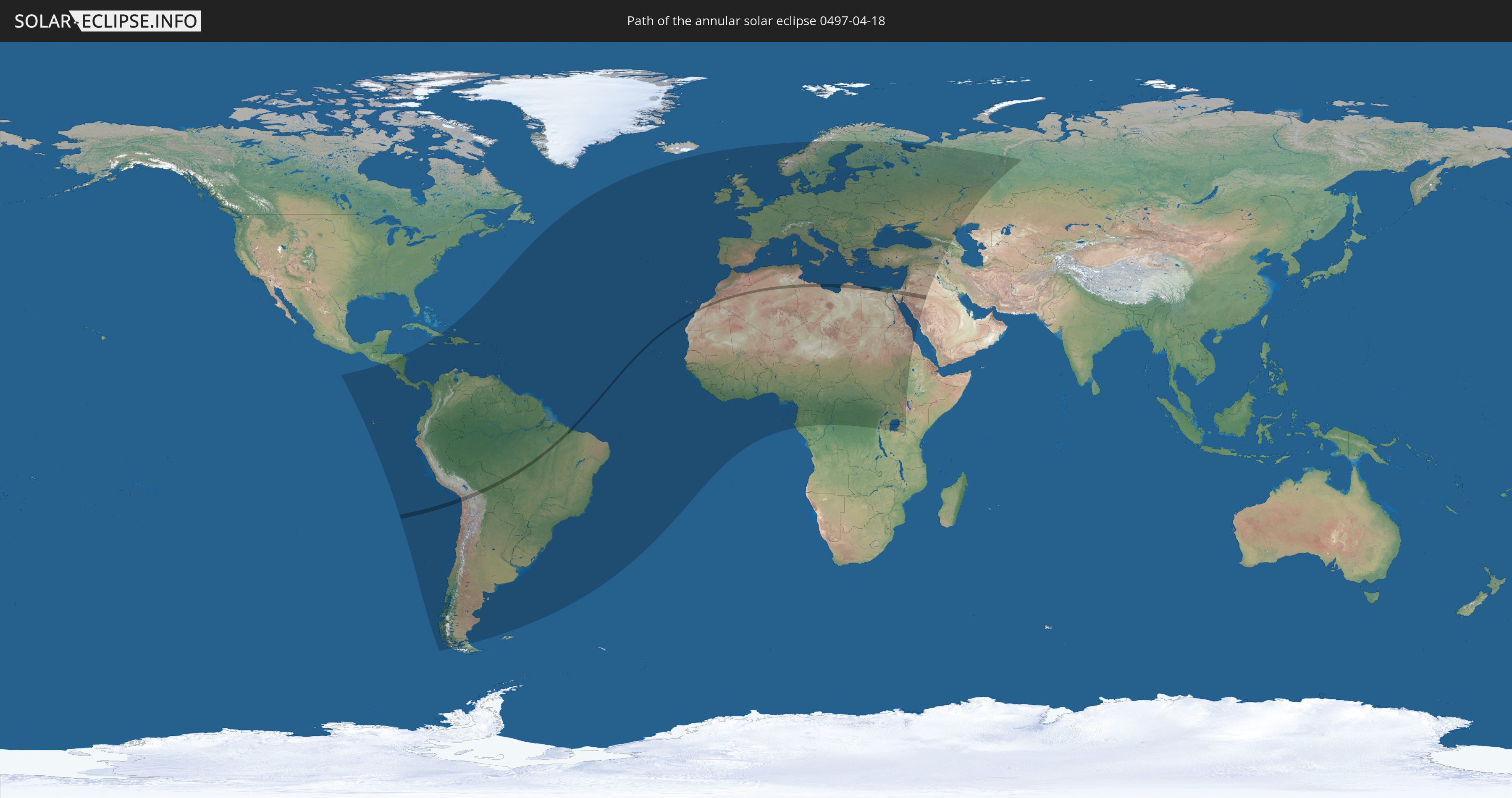
Die Sonnenfinsternis am 04/18/0497 kann man in 144 Ländern als partielle Sonnenfinsternis beobachten.
Der Finsternispfad verläuft durch 11 Länder. Nur in diesen Ländern ist sie als annular Sonnenfinsternis zu sehen.
In den folgenden Ländern ist die Sonnenfinsternis annular zu sehen
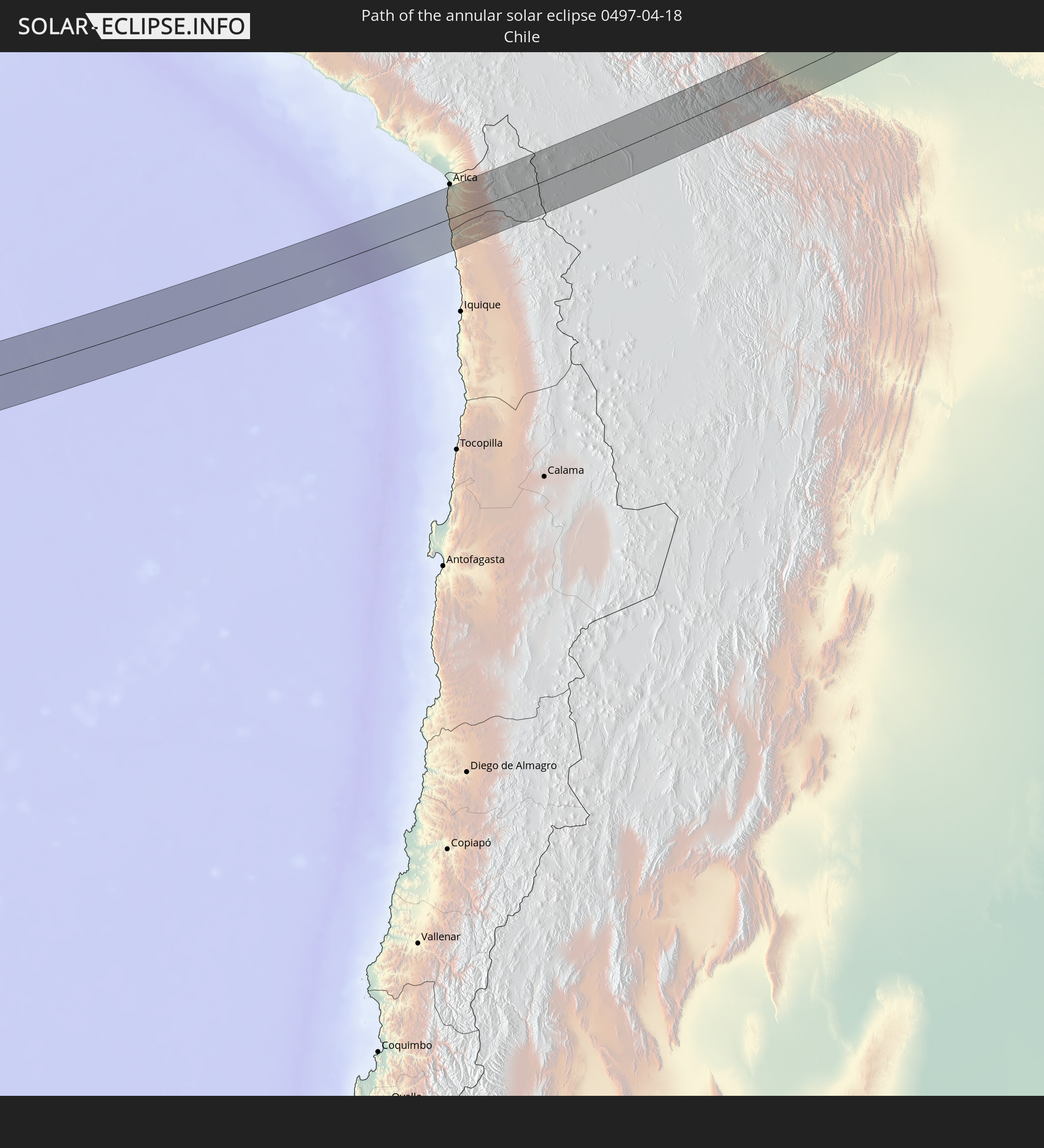 Chile
Chile
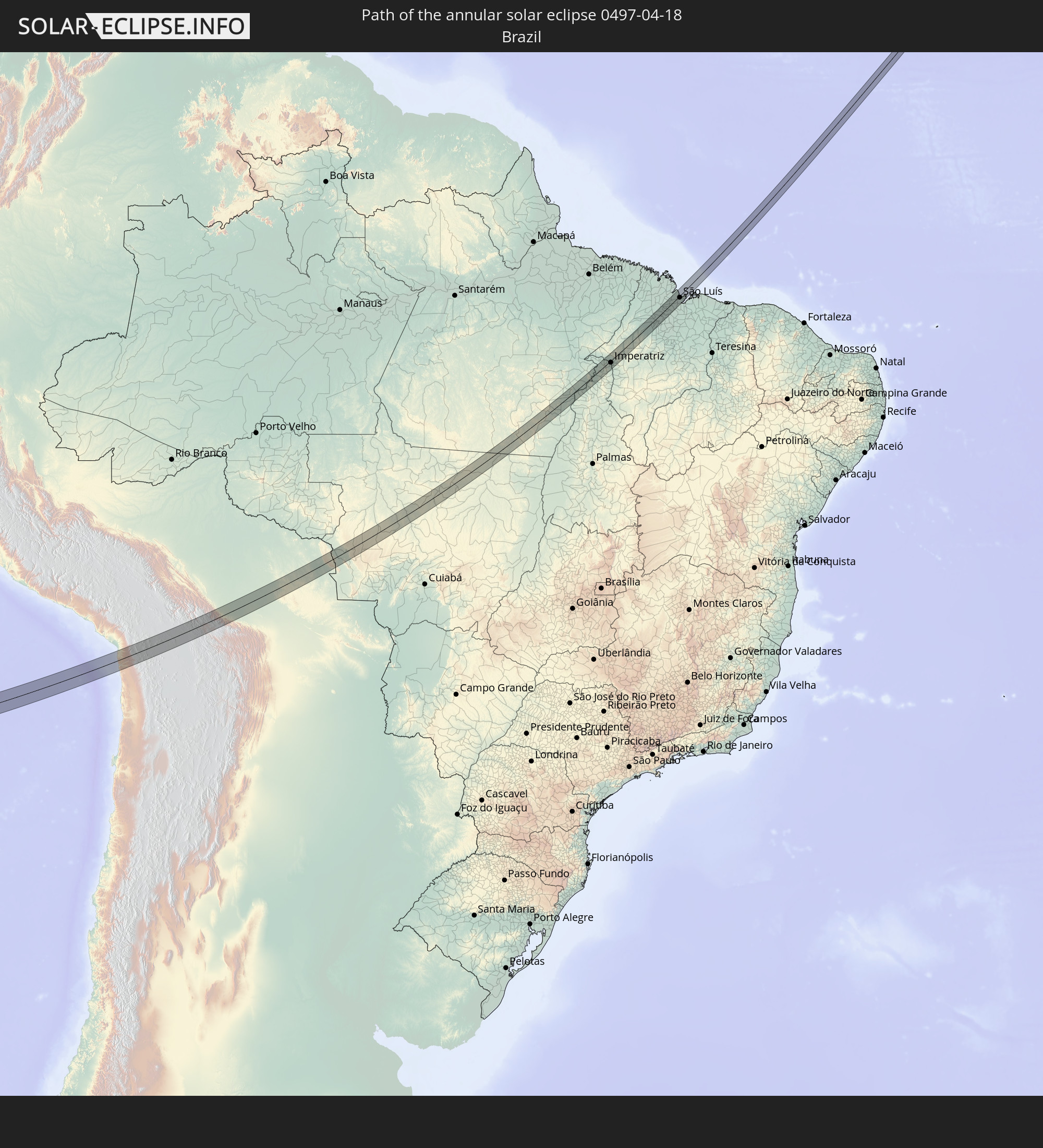 Brazil
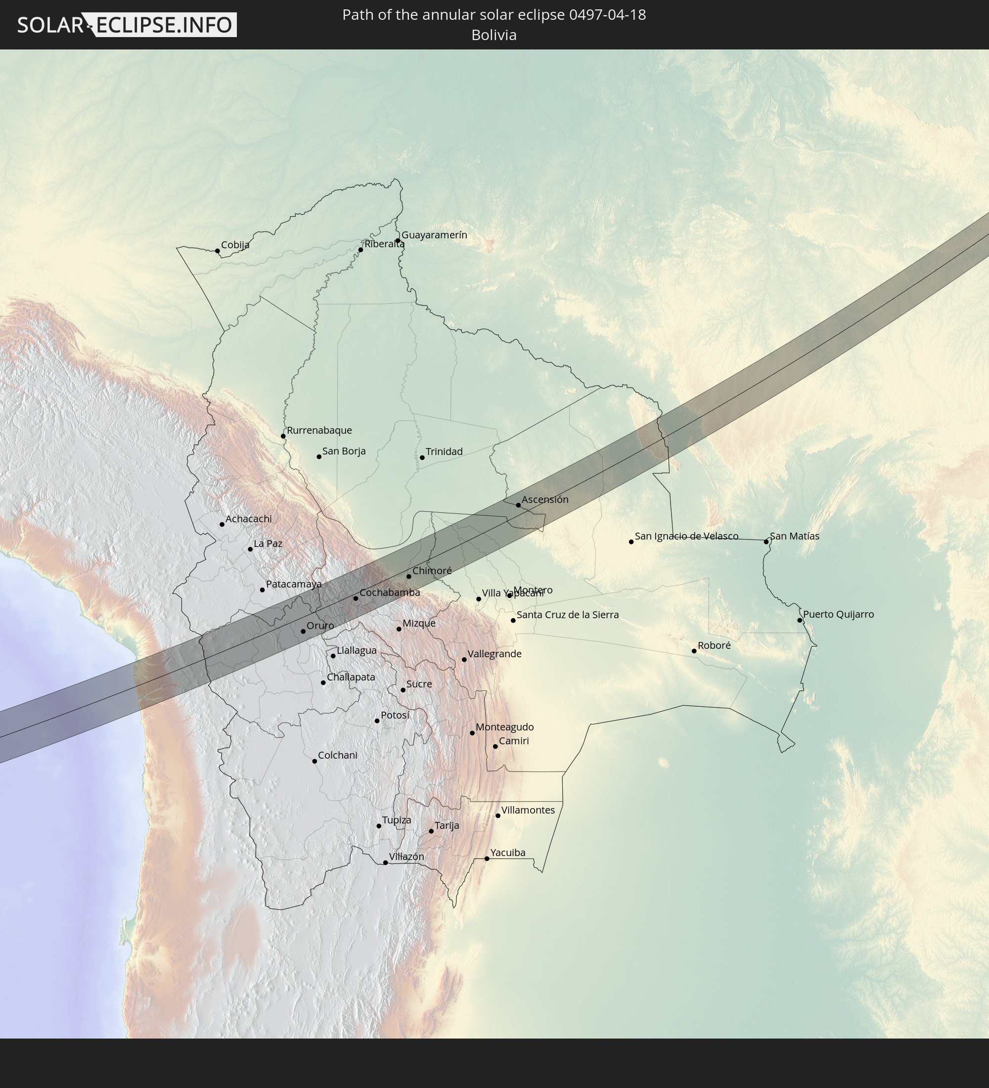 Bolivia
 Morocco
 Algeria
 Tunisia
 Libya
Libya
 Egypt
Egypt
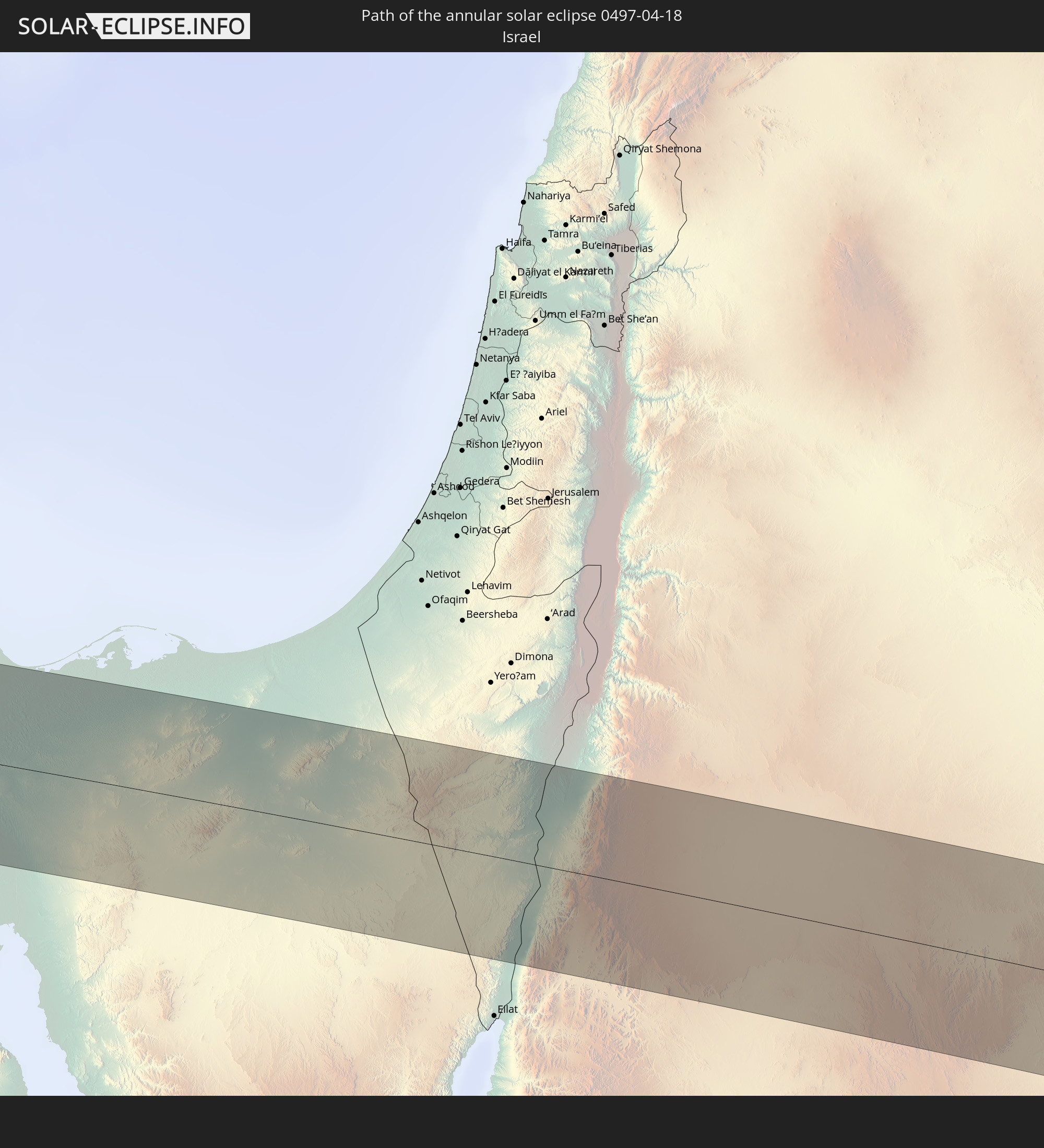 Israel
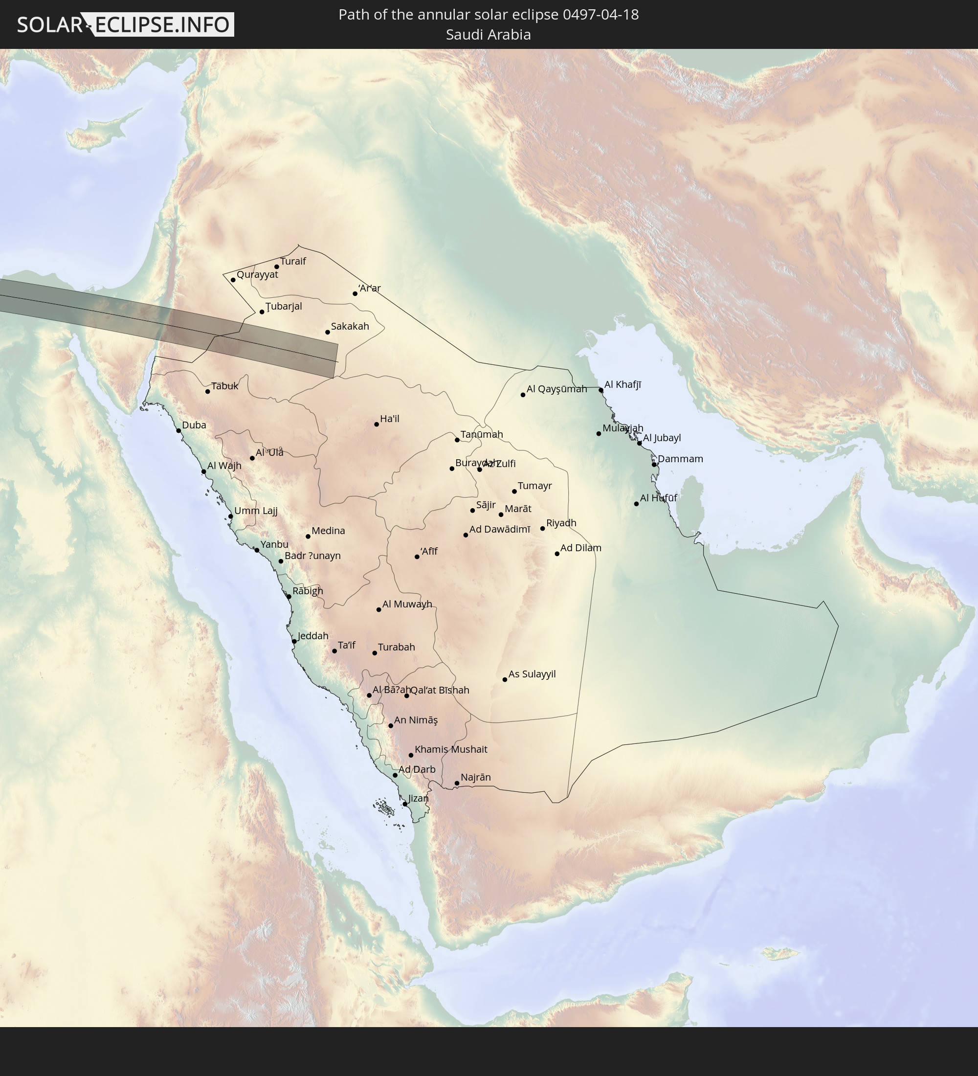 Saudi Arabia
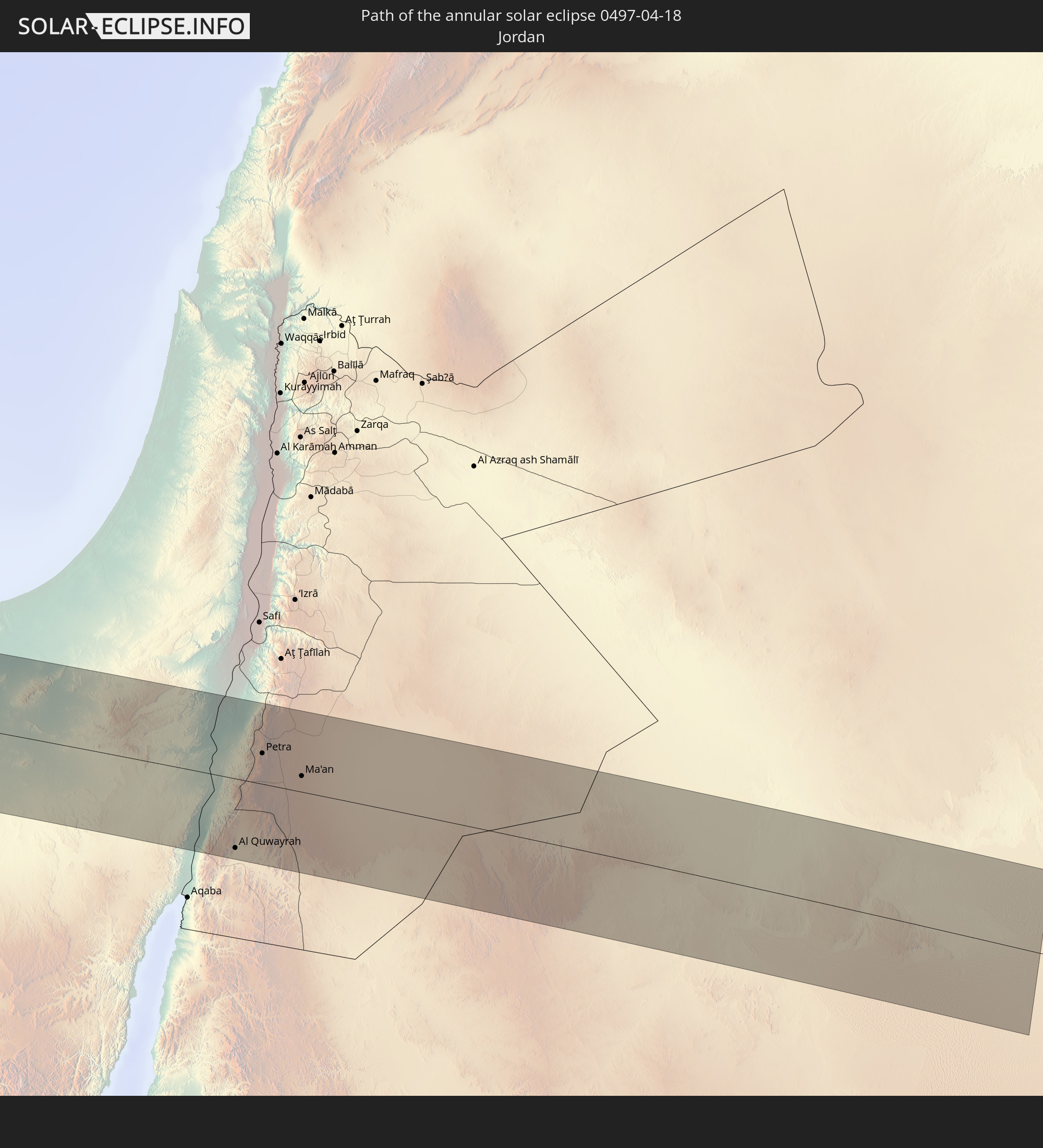 Jordan
In den folgenden Ländern ist die Sonnenfinsternis partiell zu sehen
 Russia
 United States Minor Outlying Islands
 Chile
Chile
 Ecuador
 El Salvador
 Honduras
 Nicaragua
 Costa Rica
 Cuba
Cuba
 Panama
 Colombia
 Peru
Peru
 The Bahamas
 Jamaica
 Haiti
Haiti
 Brazil
 Argentina
 Venezuela
 Turks and Caicos Islands
 Dominican Republic
 Aruba
Aruba
 Bolivia
 Puerto Rico
 United States Virgin Islands
 British Virgin Islands
 Anguilla
 Collectivity of Saint Martin
 Saint Barthélemy
 Saint Kitts and Nevis
 Paraguay
 Antigua and Barbuda
 Montserrat
 Trinidad and Tobago
 Guadeloupe
 Grenada
 Dominica
 Saint Vincent and the Grenadines
 Falkland Islands
 Guyana
 Martinique
 Saint Lucia
 Barbados
 Uruguay
 Suriname
 French Guiana
 Portugal
 Cabo Verde
 Spain
Spain
 Senegal
 Mauritania
 The Gambia
 Guinea-Bissau
 Guinea
 Saint Helena, Ascension and Tristan da Cunha
 Sierra Leone
 Morocco
 Mali
Mali
 Liberia
 Republic of Ireland
 Algeria
 United Kingdom
 Ivory Coast
 Faroe Islands
 Burkina Faso
 Gibraltar
 France
 Isle of Man
 Ghana
Ghana
 Guernsey
 Jersey
 Togo
Togo
 Niger
Niger
 Benin
Benin
 Andorra
 Belgium
 Nigeria
 Netherlands
 Norway
 Equatorial Guinea
 Luxembourg
 Germany
 Switzerland
 São Tomé and Príncipe
 Italy
Italy
 Monaco
 Tunisia
 Denmark
 Cameroon
 Gabon
Gabon
 Libya
Libya
 Liechtenstein
 Austria
 Sweden
 Republic of the Congo
 Czechia
 Democratic Republic of the Congo
 San Marino
 Vatican City
 Slovenia
 Chad
Chad
 Croatia
 Poland
 Malta
Malta
 Central African Republic
 Bosnia and Herzegovina
 Hungary
 Slovakia
 Montenegro
 Serbia
 Albania
 Åland Islands
 Greece
 Romania
 Republic of Macedonia
 Finland
 Lithuania
 Latvia
 Estonia
 Sudan
Sudan
 Ukraine
 Bulgaria
 Belarus
 Egypt
Egypt
 Turkey
 Moldova
 Rwanda
 Tanzania
 Uganda
 Cyprus
 Ethiopia
 Kenya
Kenya
 State of Palestine
 Israel
 Saudi Arabia
 Jordan
 Lebanon
 Syria
Syria
 Eritrea
 Iraq
Iraq
 Georgia
 Armenia
 Iran
Iran
 Azerbaijan
 Kazakhstan
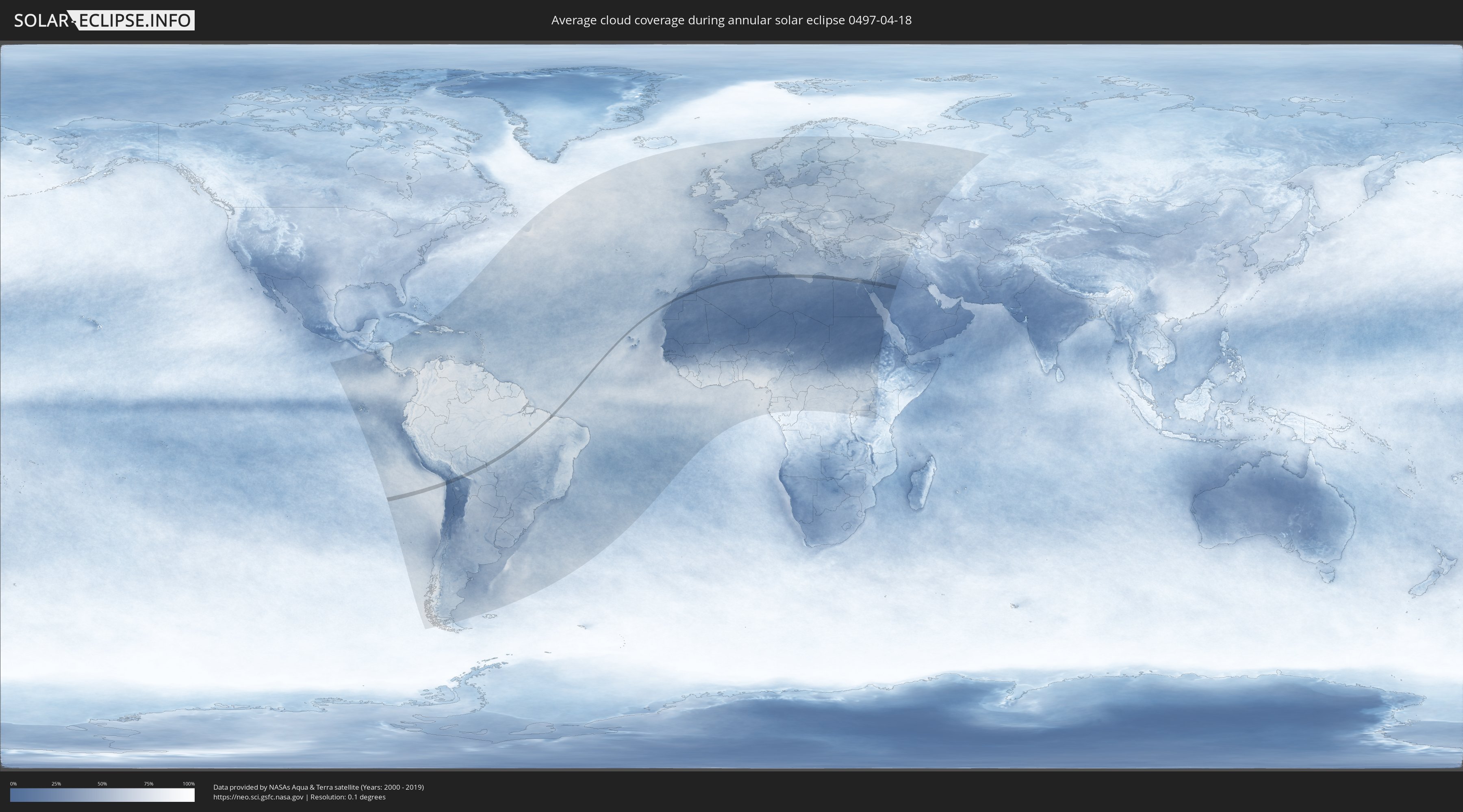
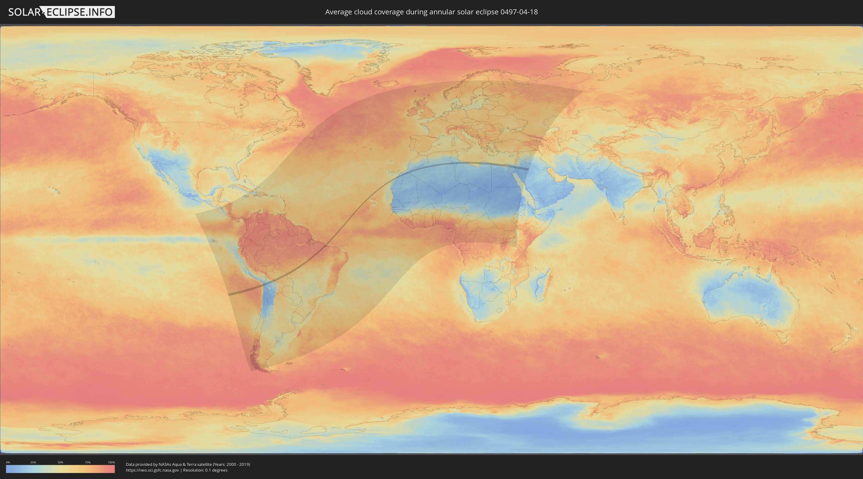
How will be the weather during the annular solar eclipse on 04/18/0497?
Where is the best place to see the annular solar eclipse of 04/18/0497?
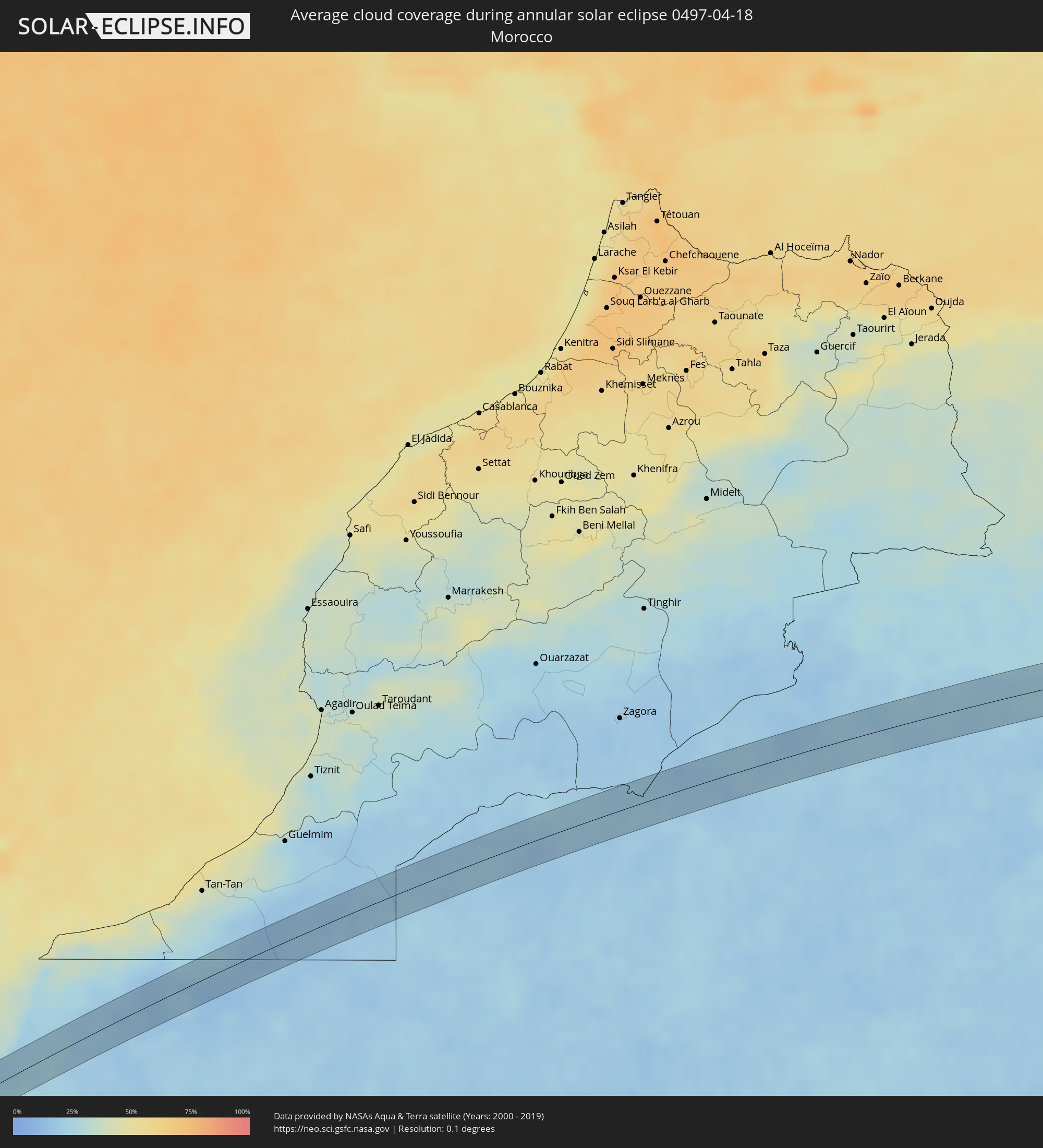
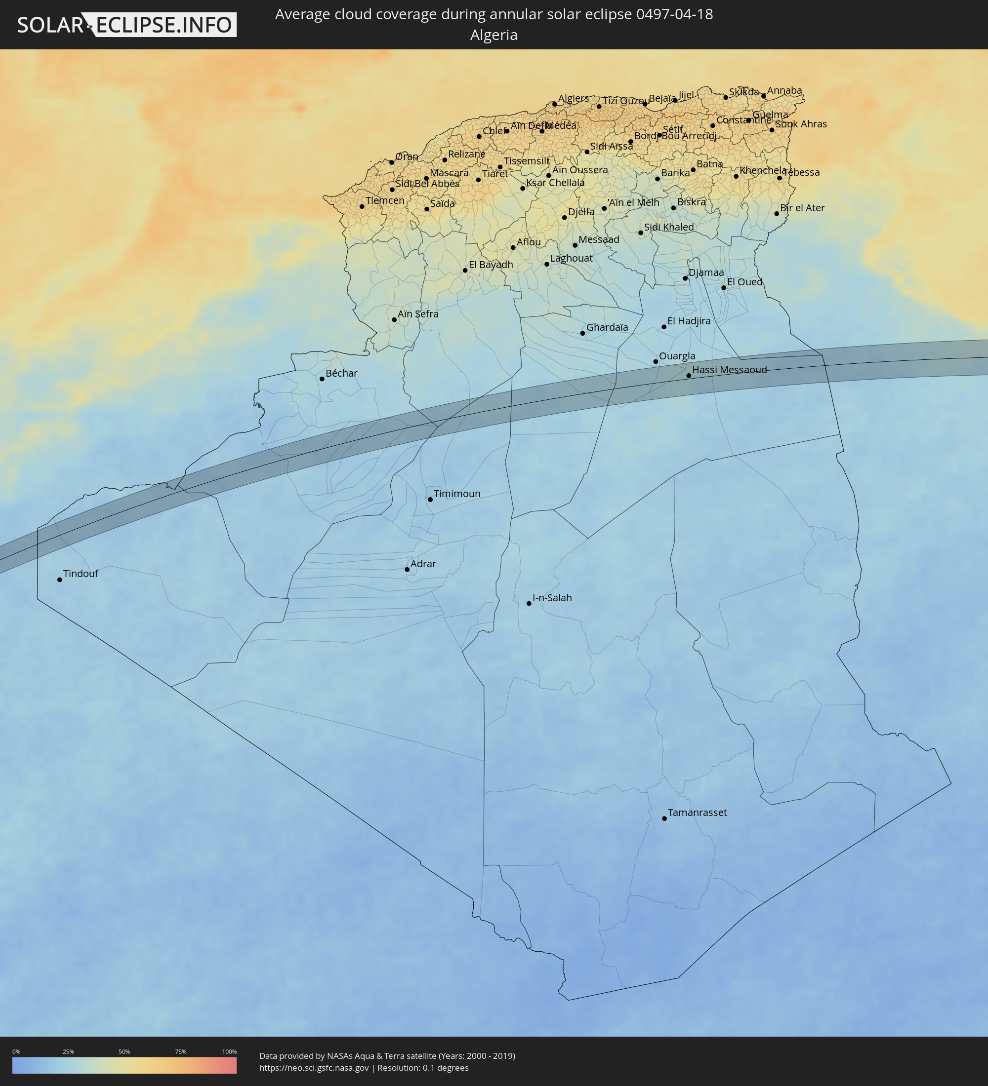
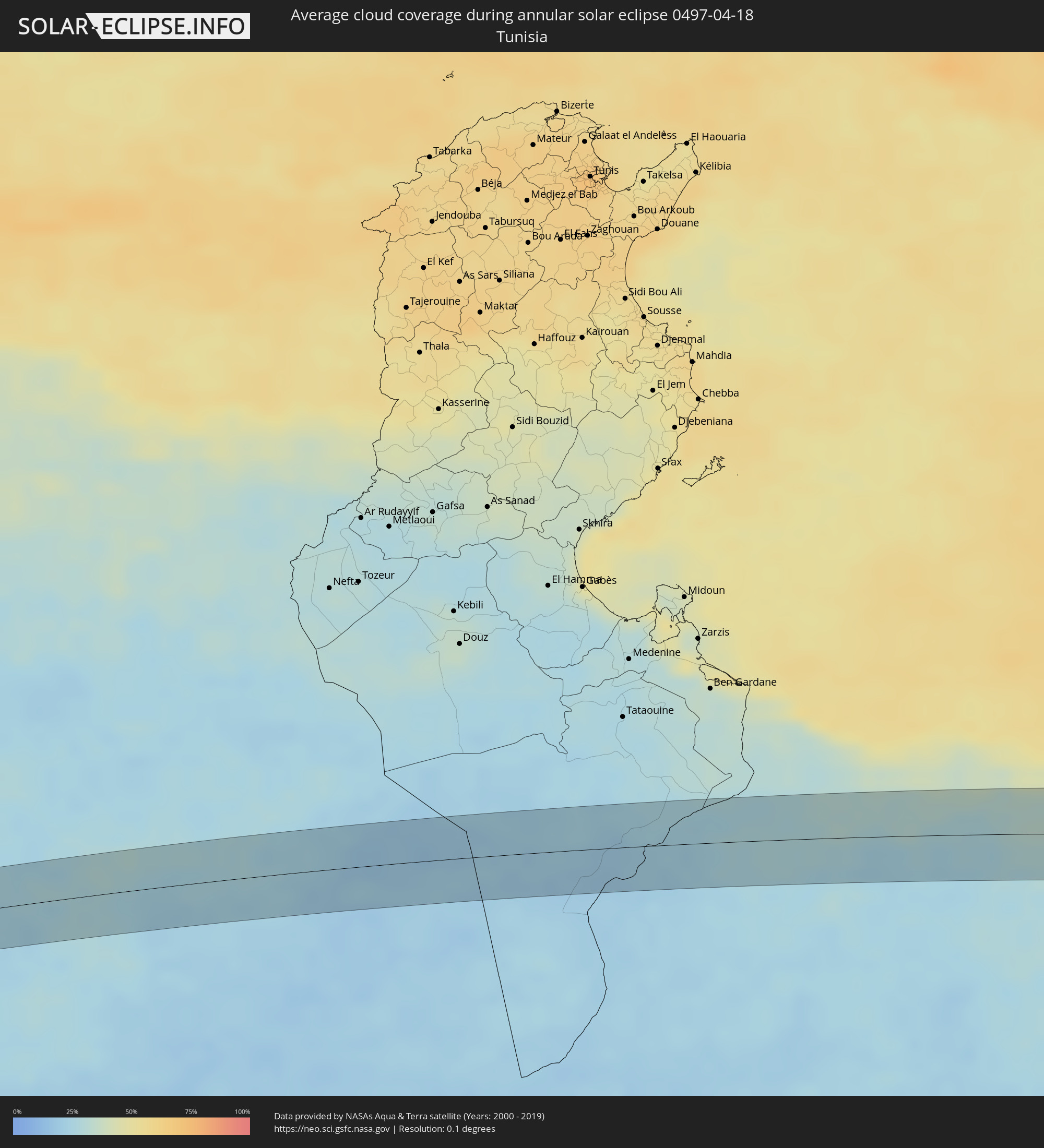
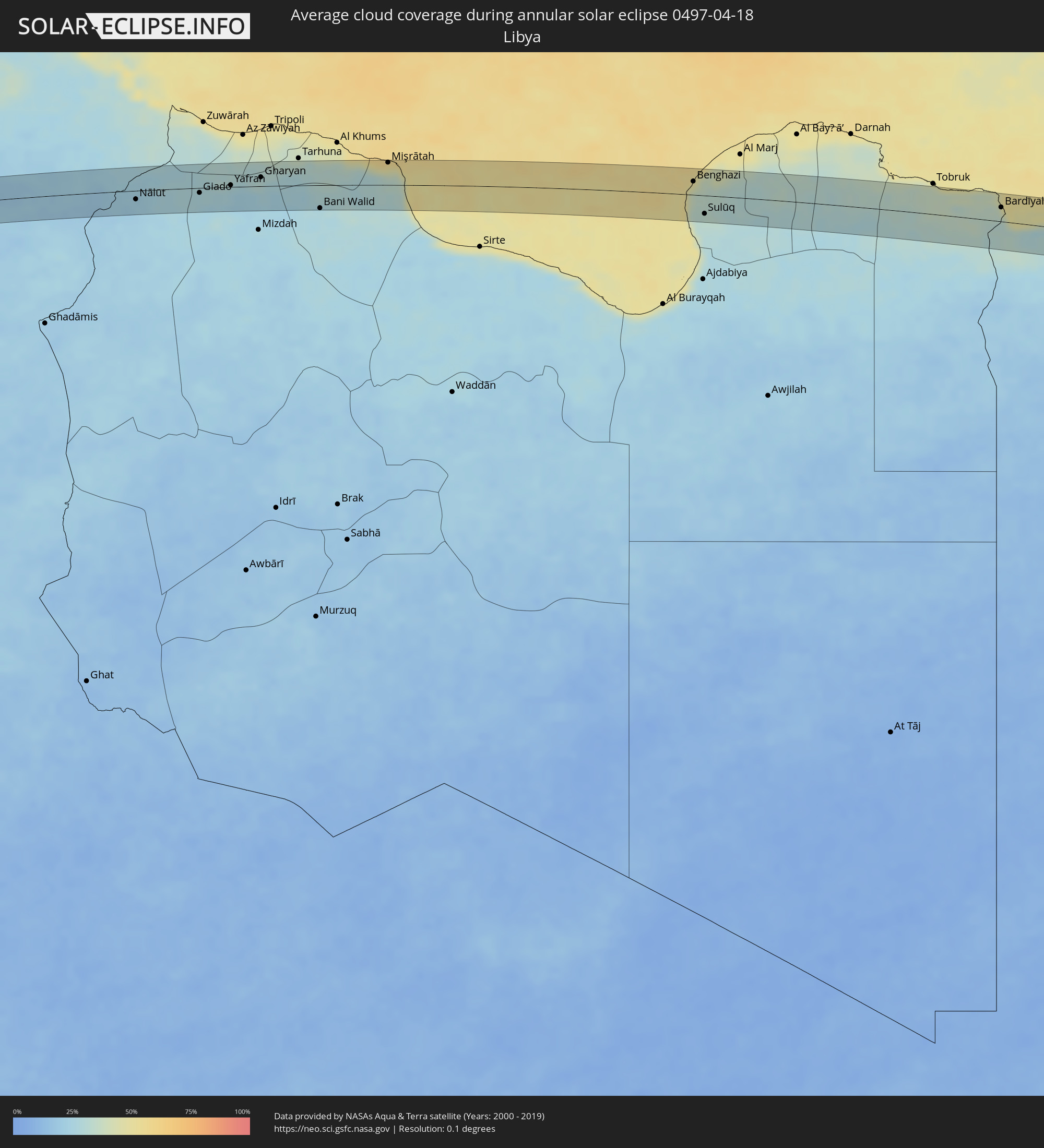
The following maps show the average cloud coverage for the day of the annular solar eclipse.
With the help of these maps, it is possible to find the place along the eclipse path, which has the best
chance of a cloudless sky.
Nevertheless, you should consider local circumstances and inform about the weather of your chosen
observation site.
The data is provided by NASAs satellites
AQUA and TERRA.
The cloud maps are averaged over a period of 19 years (2000 - 2019).
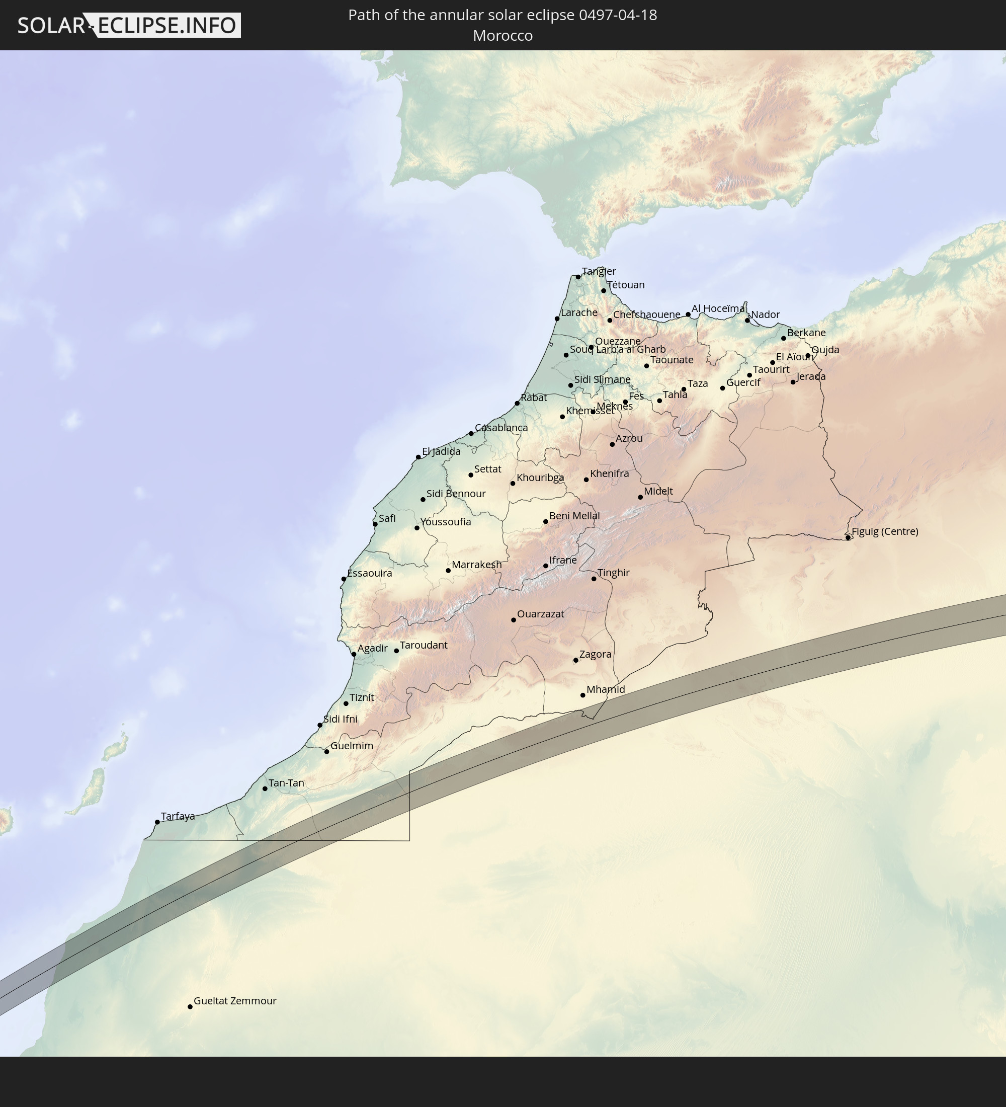
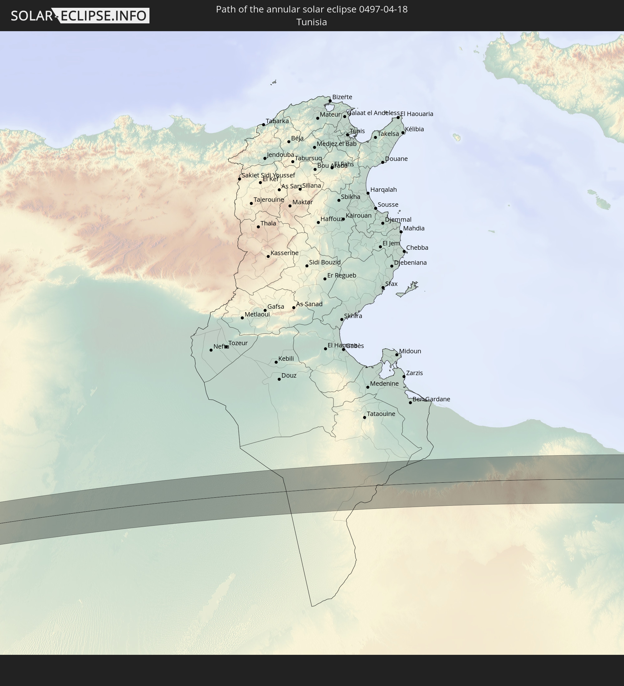
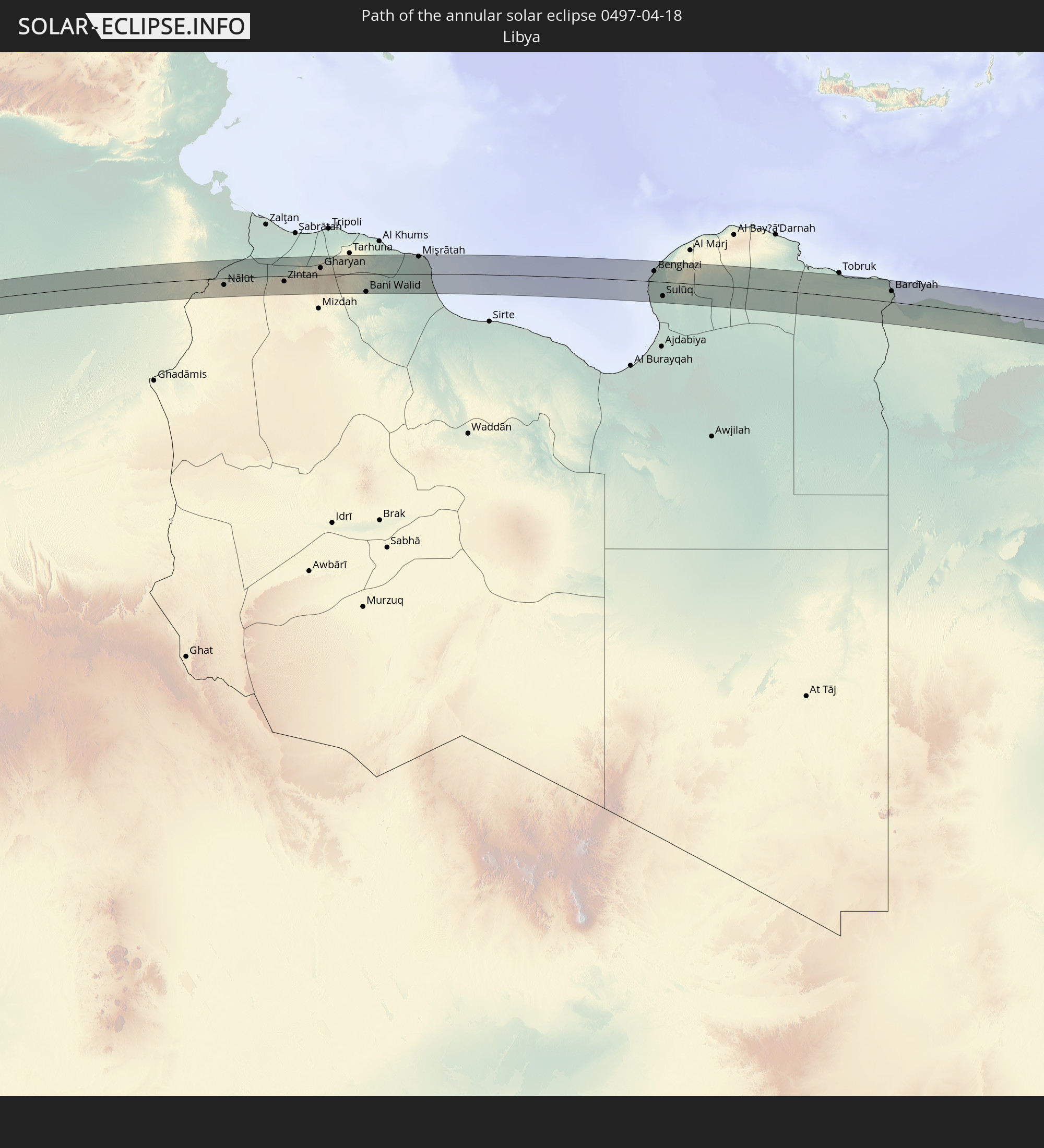
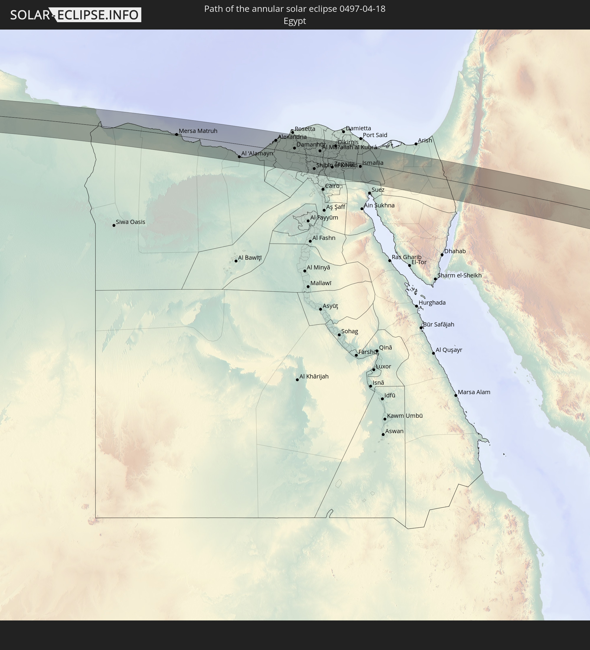
Detailed country maps
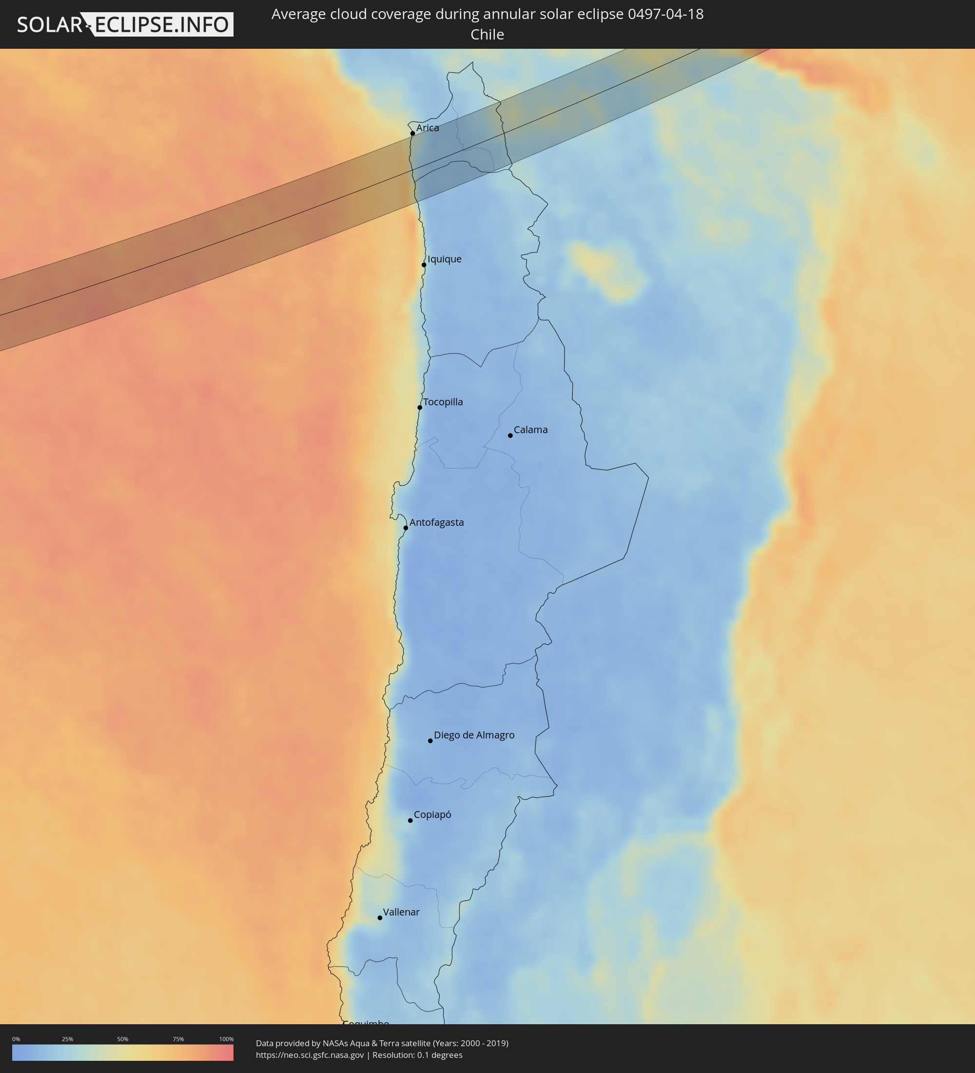 Chile
Chile
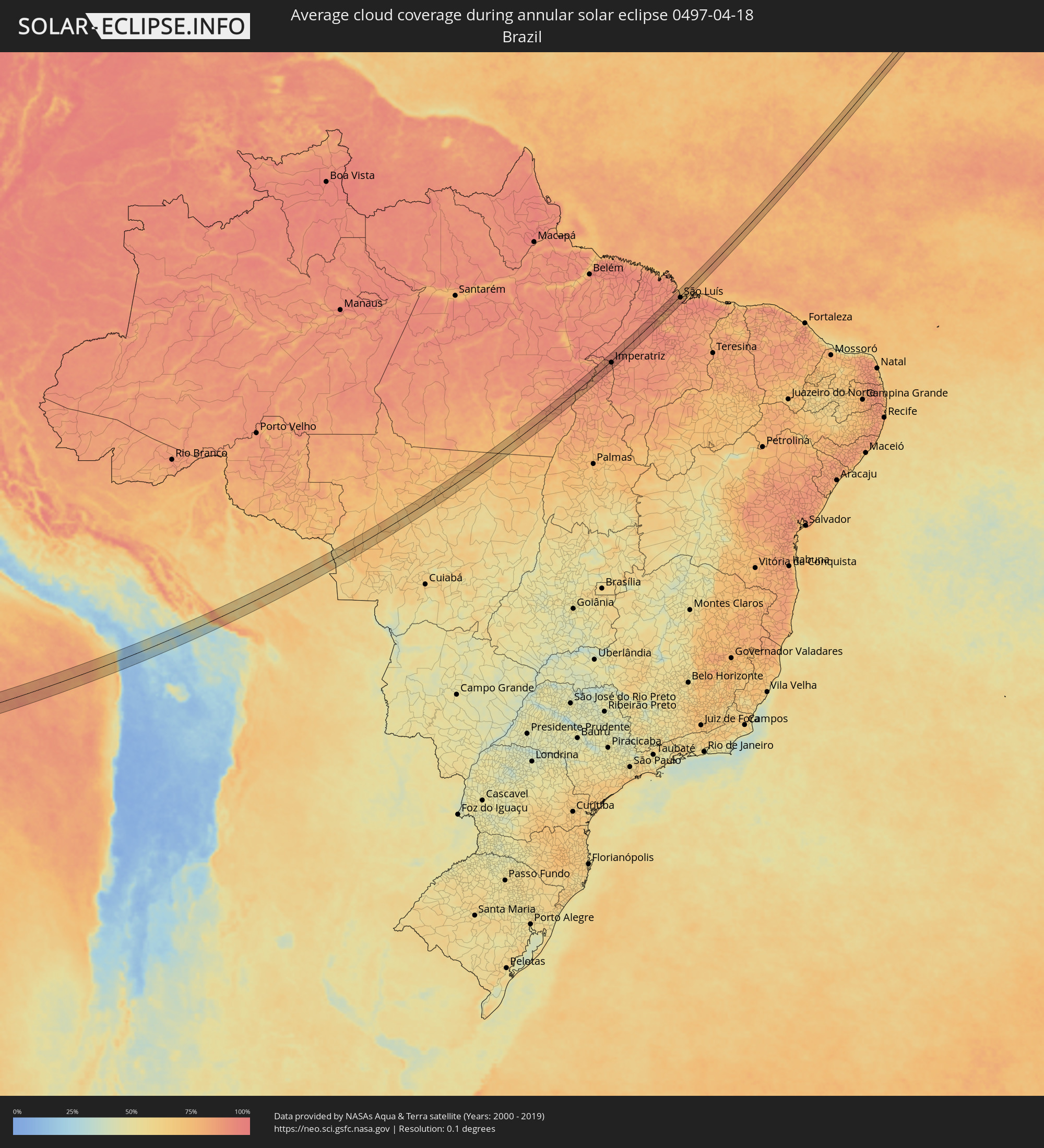 Brazil
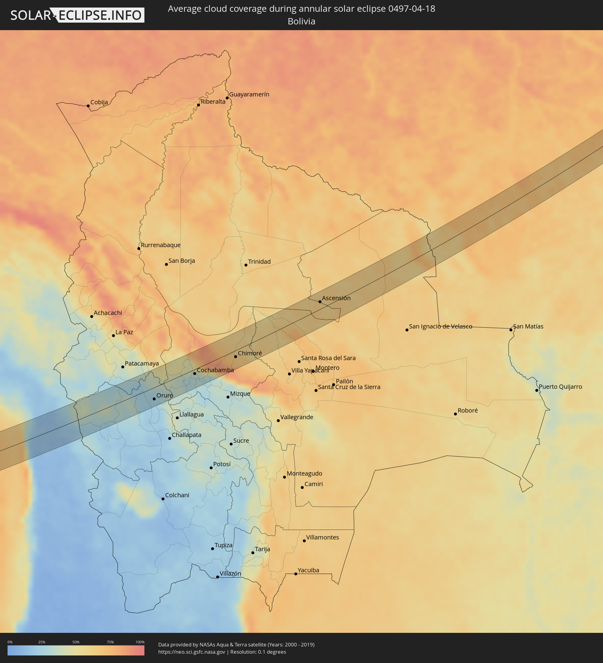 Bolivia
 Morocco
 Algeria
 Tunisia
 Libya
Libya
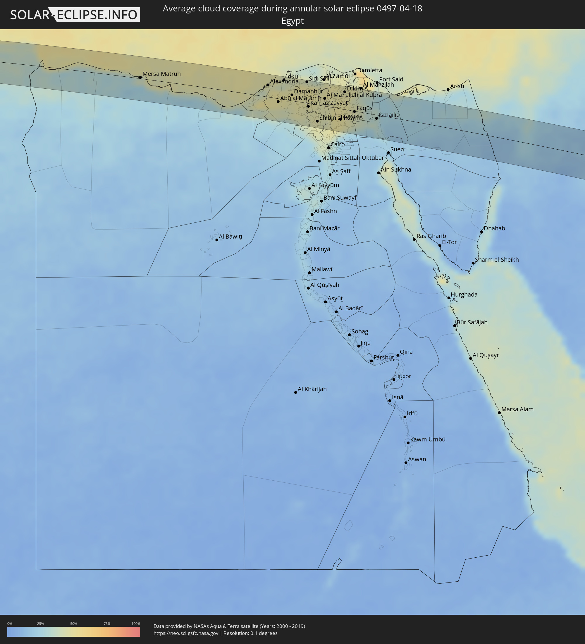 Egypt
Egypt
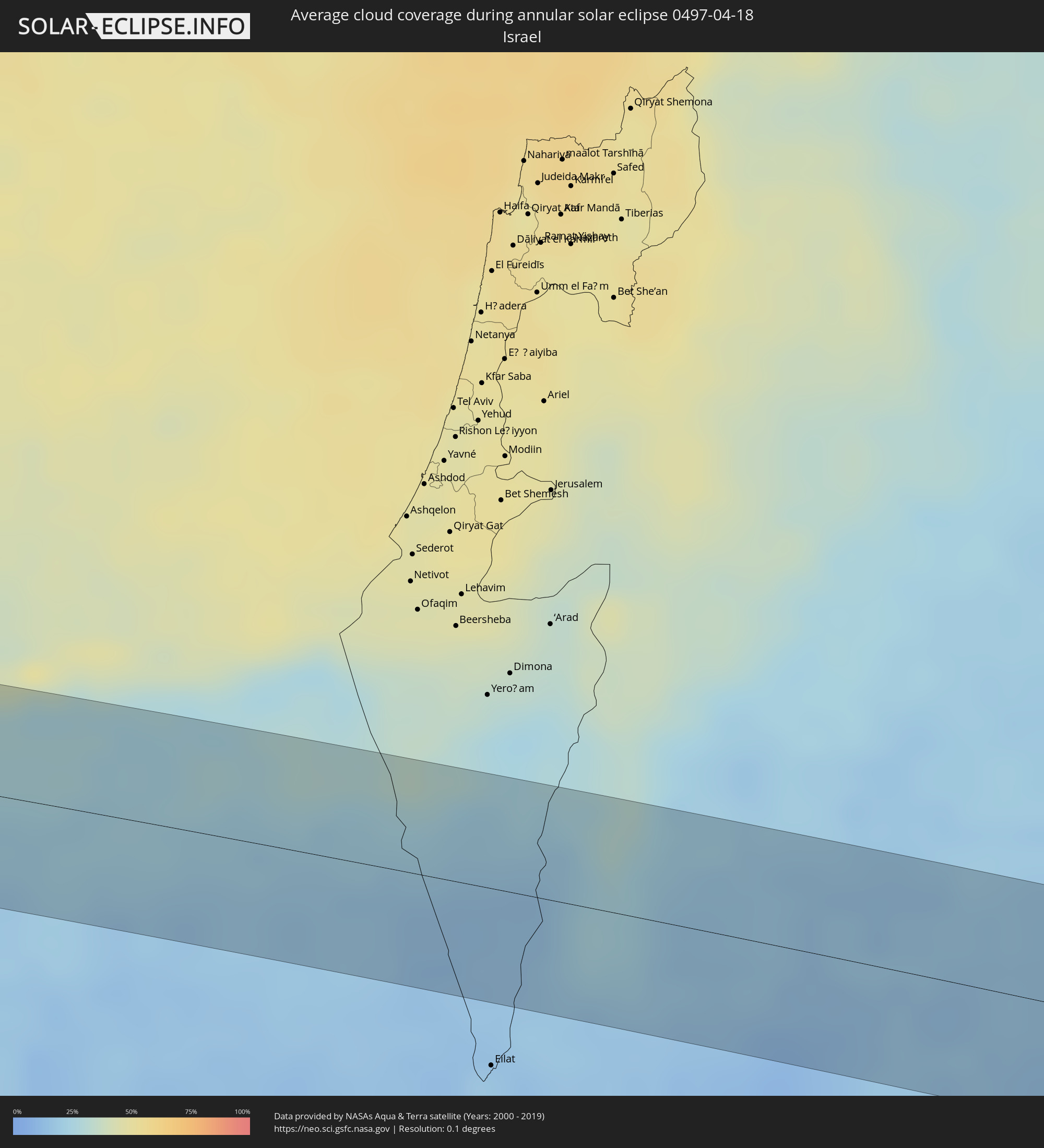 Israel
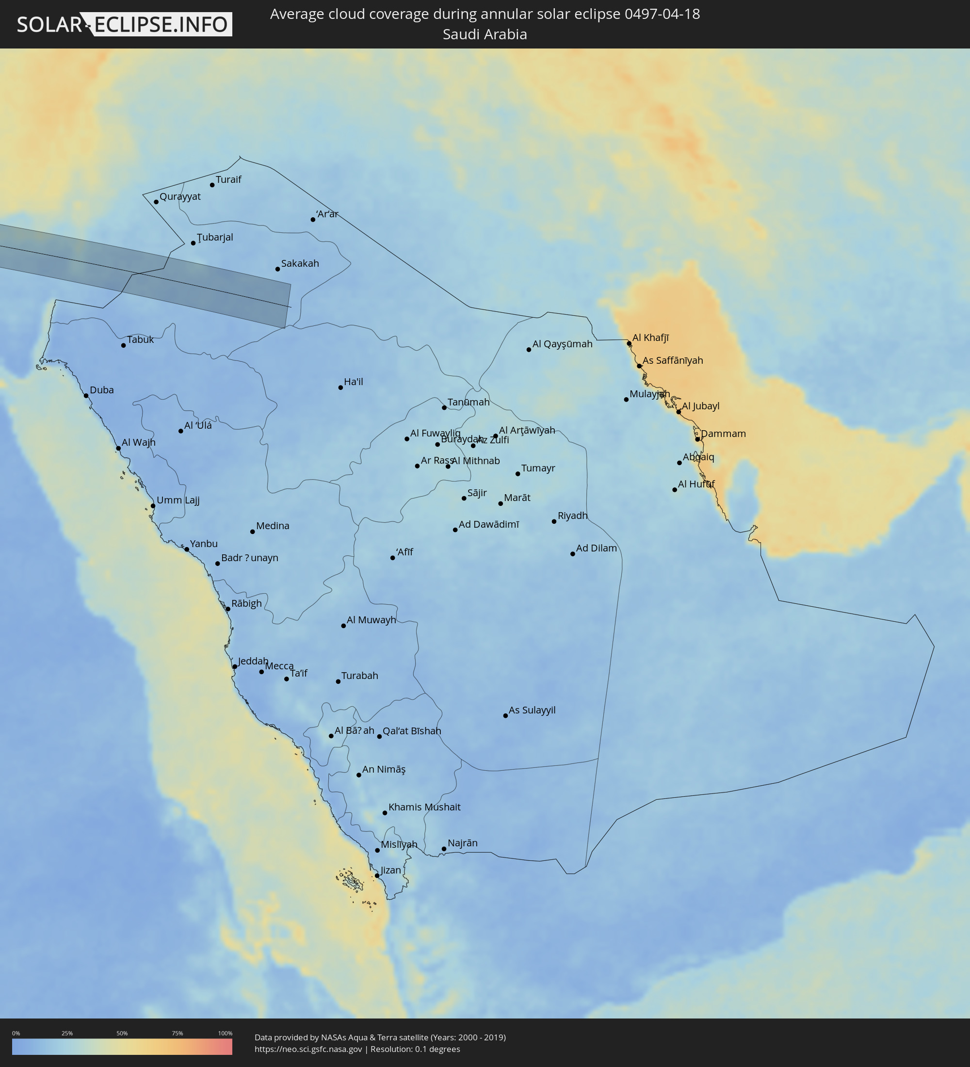 Saudi Arabia
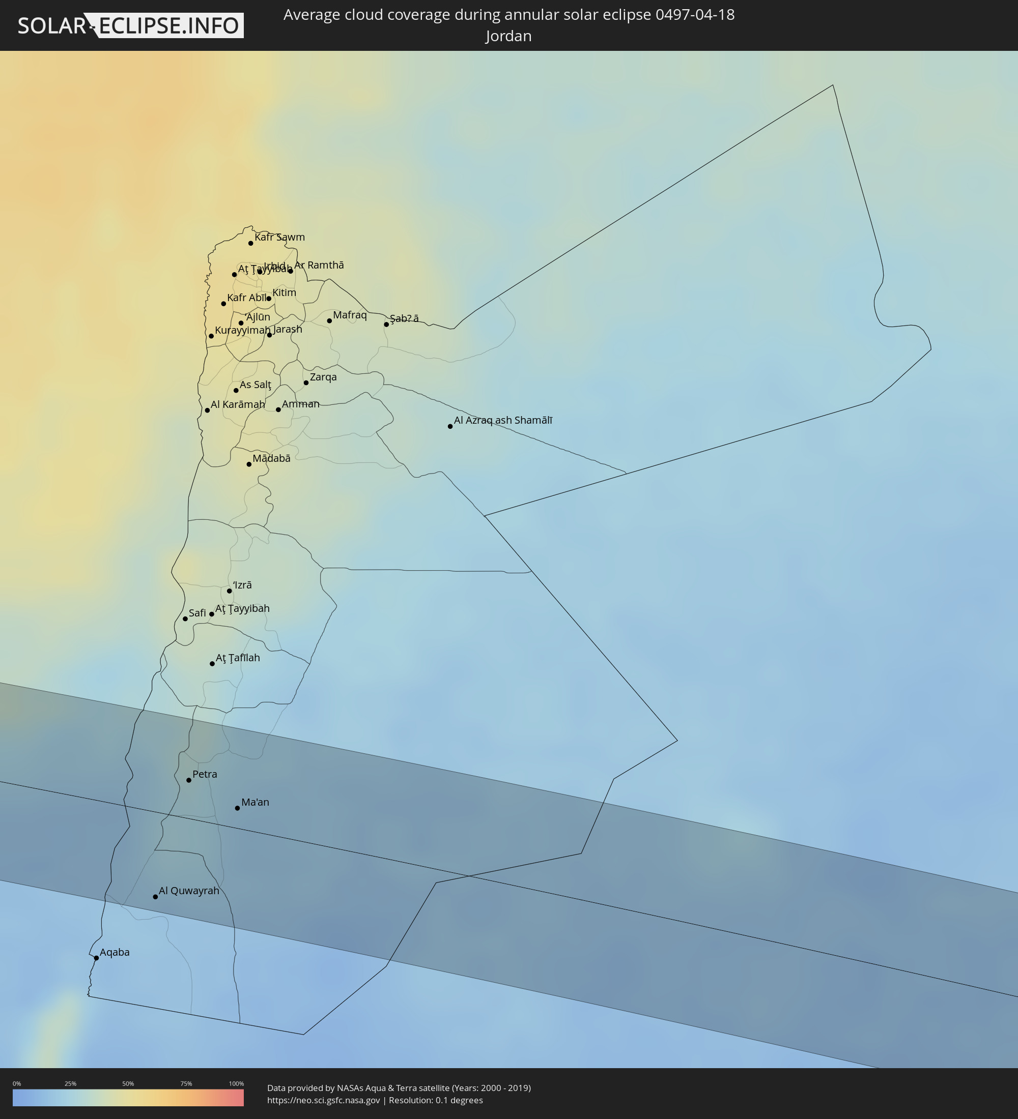 Jordan
Cities inside the path of the eclipse
The following table shows all locations with a population of more than 5,000 inside the eclipse path. Cities which have more than 100,000 inhabitants are marked bold. A click at the locations opens a detailed map.
| City | Type | Eclipse duration | Local time of max. eclipse | Distance to central line | Ø Cloud coverage |
|
Oruro, Oruro
|
annular | - | 07:29:39 UTC-04:32 | 28 km | 23% |
|
Capinota, Cochabamba
|
annular | - | 07:30:16 UTC-04:32 | 39 km | 30% |
|
Cochabamba, Cochabamba
|
annular | - | 07:30:34 UTC-04:32 | 11 km | 32% |
|
Tarata, Cochabamba
|
annular | - | 07:30:28 UTC-04:32 | 39 km | 29% |
|
Cliza, Cochabamba
|
annular | - | 07:30:31 UTC-04:32 | 41 km | 28% |
|
Punata, Cochabamba
|
annular | - | 07:30:36 UTC-04:32 | 40 km | 28% |
|
Chimoré, Cochabamba
|
annular | - | 07:31:23 UTC-04:32 | 16 km | 69% |
|
Ascensión, Santa Cruz
|
annular | - | 07:33:39 UTC-04:32 | 17 km | 63% |
|
Sinop, Mato Grosso
|
annular | - | 08:37:35 UTC-03:38 | 28 km | 72% |
|
São Geraldo do Araguaia, Pará
|
annular | - | 09:17:26 UTC-03:13 | 4 km | 85% |
|
Imperatriz, Maranhão
|
annular | - | 10:00:11 UTC-02:34 | 8 km | 89% |
|
Santa Inês, Maranhão
|
annular | - | 10:06:19 UTC-02:34 | 15 km | 90% |
|
Pindaré Mirim, Maranhão
|
annular | - | 10:06:29 UTC-02:34 | 13 km | 87% |
|
Monção, Maranhão
|
annular | - | 10:06:49 UTC-02:34 | 11 km | 82% |
|
Penalva, Maranhão
|
annular | - | 10:07:18 UTC-02:34 | 1 km | 77% |
|
Matinha, Maranhão
|
annular | - | 10:07:52 UTC-02:34 | 4 km | 80% |
|
Viana, Maranhão
|
annular | - | 10:07:41 UTC-02:34 | 8 km | 80% |
|
São Bento, Maranhão
|
annular | - | 10:08:56 UTC-02:34 | 20 km | 87% |
|
Alcântara, Maranhão
|
annular | - | 10:10:04 UTC-02:34 | 11 km | 81% |
|
São Luís, Maranhão
|
annular | - | 10:09:59 UTC-02:34 | 8 km | 92% |
|
Hassi Messaoud, Ouargla
|
annular | - | 15:31:58 UTC+00:09 | 5 km | 25% |
|
Nālūt, Sha‘bīyat Nālūt
|
annular | - | 16:20:46 UTC+00:52 | 13 km | 23% |
|
Giado
|
annular | - | 16:21:47 UTC+00:52 | 7 km | 27% |
|
Zintan, Jabal al Gharbi District
|
annular | - | 16:22:00 UTC+00:52 | 11 km | 25% |
|
Yafran, Jabal al Gharbi District
|
annular | - | 16:22:15 UTC+00:52 | 3 km | 28% |
|
Gharyan, Jabal al Gharbi District
|
annular | - | 16:22:42 UTC+00:52 | 14 km | 30% |
|
Bani Walid, Mişrātah
|
annular | - | 16:23:36 UTC+00:52 | 35 km | 27% |
|
Mişrātah, Mişrātah
|
annular | - | 16:24:27 UTC+00:52 | 34 km | 46% |
|
Benghazi, Banghāzī
|
annular | - | 16:28:05 UTC+00:52 | 20 km | 40% |
|
Sulūq, Banghāzī
|
annular | - | 16:28:17 UTC+00:52 | 28 km | 33% |
|
Al Abyār, Al Marj
|
annular | - | 16:28:23 UTC+00:52 | 32 km | 37% |
|
Bardīyah, Sha‘bīyat al Buţnān
|
annular | - | 16:30:49 UTC+00:52 | 22 km | 44% |
|
Mersa Matruh, Matruh
|
annular | - | 17:39:03 UTC+02:00 | 2 km | 37% |
|
Alexandria, Alexandria
|
annular | - | 17:39:57 UTC+02:00 | 24 km | 46% |
|
Kafr ad Dawwār, Beheira
|
annular | - | 17:40:01 UTC+02:00 | 17 km | 49% |
|
Ḩawsh ‘Īsá, Beheira
|
annular | - | 17:40:08 UTC+02:00 | 5 km | 47% |
|
Idkū, Beheira
|
annular | - | 17:40:01 UTC+02:00 | 39 km | 39% |
|
Damanhūr, Beheira
|
annular | - | 17:40:08 UTC+02:00 | 11 km | 46% |
|
Fuwwah, Kafr el-Sheikh
|
annular | - | 17:40:06 UTC+02:00 | 31 km | 48% |
|
Disūq, Kafr el-Sheikh
|
annular | - | 17:40:09 UTC+02:00 | 25 km | 48% |
|
Sīdī Sālim, Kafr el-Sheikh
|
annular | - | 17:40:08 UTC+02:00 | 42 km | 48% |
|
Basyūn, Gharbia
|
annular | - | 17:40:15 UTC+02:00 | 6 km | 47% |
|
Kafr az Zayyāt, Gharbia
|
annular | - | 17:40:17 UTC+02:00 | 6 km | 44% |
|
Ash Shuhadā’, Monufia
|
annular | - | 17:40:23 UTC+02:00 | 30 km | 43% |
|
Minūf, Monufia
|
annular | - | 17:40:25 UTC+02:00 | 44 km | 42% |
|
Kafr ash Shaykh, Kafr el-Sheikh
|
annular | - | 17:40:14 UTC+02:00 | 27 km | 49% |
|
Talā, Monufia
|
annular | - | 17:40:22 UTC+02:00 | 20 km | 44% |
|
Tanda, Gharbia
|
annular | - | 17:40:21 UTC+02:00 | 8 km | 45% |
|
Shibīn al Kawm, Monufia
|
annular | - | 17:40:25 UTC+02:00 | 33 km | 45% |
|
Al Maḩallah al Kubrá, Gharbia
|
annular | - | 17:40:19 UTC+02:00 | 15 km | 46% |
|
Banhā, Qalyubia
|
annular | - | 17:40:29 UTC+02:00 | 41 km | 45% |
|
Samannūd, Gharbia
|
annular | - | 17:40:21 UTC+02:00 | 15 km | 46% |
|
Ziftá, Gharbia
|
annular | - | 17:40:25 UTC+02:00 | 12 km | 43% |
|
Bilqās, Dakahlia
|
annular | - | 17:40:17 UTC+02:00 | 45 km | 47% |
|
Al Manşūrah, Dakahlia
|
annular | - | 17:40:21 UTC+02:00 | 26 km | 47% |
|
Diyarb Najm, Sharqia
|
annular | - | 17:40:27 UTC+02:00 | 5 km | 49% |
|
Zagazig, Sharqia
|
annular | - | 17:40:31 UTC+02:00 | 22 km | 50% |
|
Shirbīn, Dakahlia
|
annular | - | 17:40:20 UTC+02:00 | 45 km | 46% |
|
Bilbays, Sharqia
|
annular | - | 17:40:35 UTC+02:00 | 39 km | 30% |
|
Dikirnis, Dakahlia
|
annular | - | 17:40:23 UTC+02:00 | 35 km | 47% |
|
Minyat an Naşr, Dakahlia
|
annular | - | 17:40:23 UTC+02:00 | 40 km | 47% |
|
Abū Kabīr, Sharqia
|
annular | - | 17:40:31 UTC+02:00 | 4 km | 45% |
|
Al Qurayn, Sharqia
|
annular | - | 17:40:33 UTC+02:00 | 15 km | 45% |
|
At Tall al Kabīr, Ismailia
|
annular | - | 17:40:35 UTC+02:00 | 22 km | 36% |
|
Fāqūs, Sharqia
|
annular | - | 17:40:32 UTC+02:00 | 1 km | 42% |
|
Ismailia, Ismailia
|
annular | - | 17:40:40 UTC+02:00 | 7 km | 33% |
|
Al Quwayrah, Ma’an
|
annular | - | 18:05:05 UTC+02:23 | 42 km | 17% |
|
Petra, Ma’an
|
annular | - | 18:04:56 UTC+02:23 | 18 km | 26% |
|
Ma'an, Ma’an
|
annular | - | 18:05:00 UTC+02:23 | 10 km | 20% |