Totale Sonnenfinsternis vom 23.11.-1040
| Wochentag: | Freitag |
| Maximale Dauer der Verfinsterung: | 03m45s |
| Maximale Breite des Finsternispfades: | 151 km |
| Saroszyklus: | 45 |
| Bedeckungsgrad: | 100% |
| Magnitude: | 1.039 |
| Gamma: | 0.5062 |
Wo kann man die Sonnenfinsternis vom 23.11.-1040 sehen?
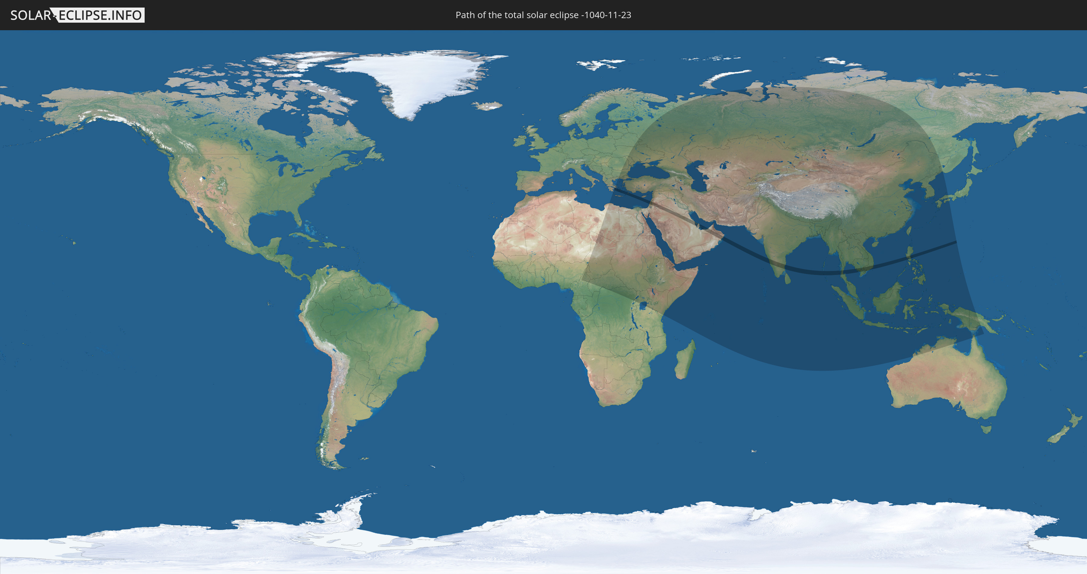
Die Sonnenfinsternis am 23.11.-1040 kann man in 82 Ländern als partielle Sonnenfinsternis beobachten.
Der Finsternispfad verläuft durch 18 Länder. Nur in diesen Ländern ist sie als totale Sonnenfinsternis zu sehen.
In den folgenden Ländern ist die Sonnenfinsternis total zu sehen
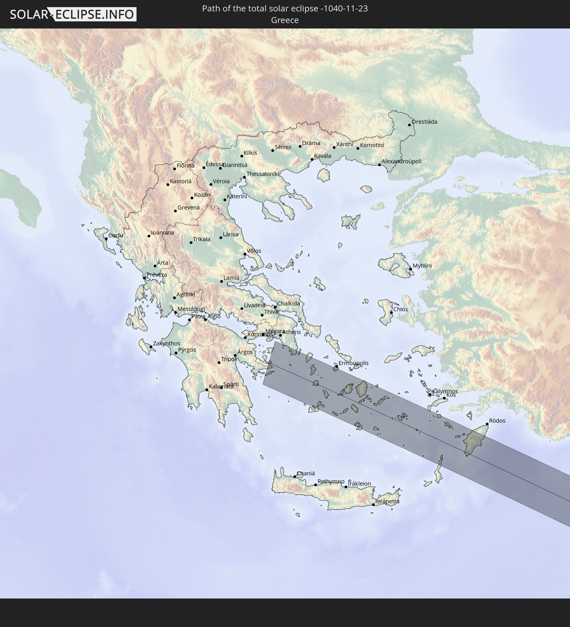 Griechenland
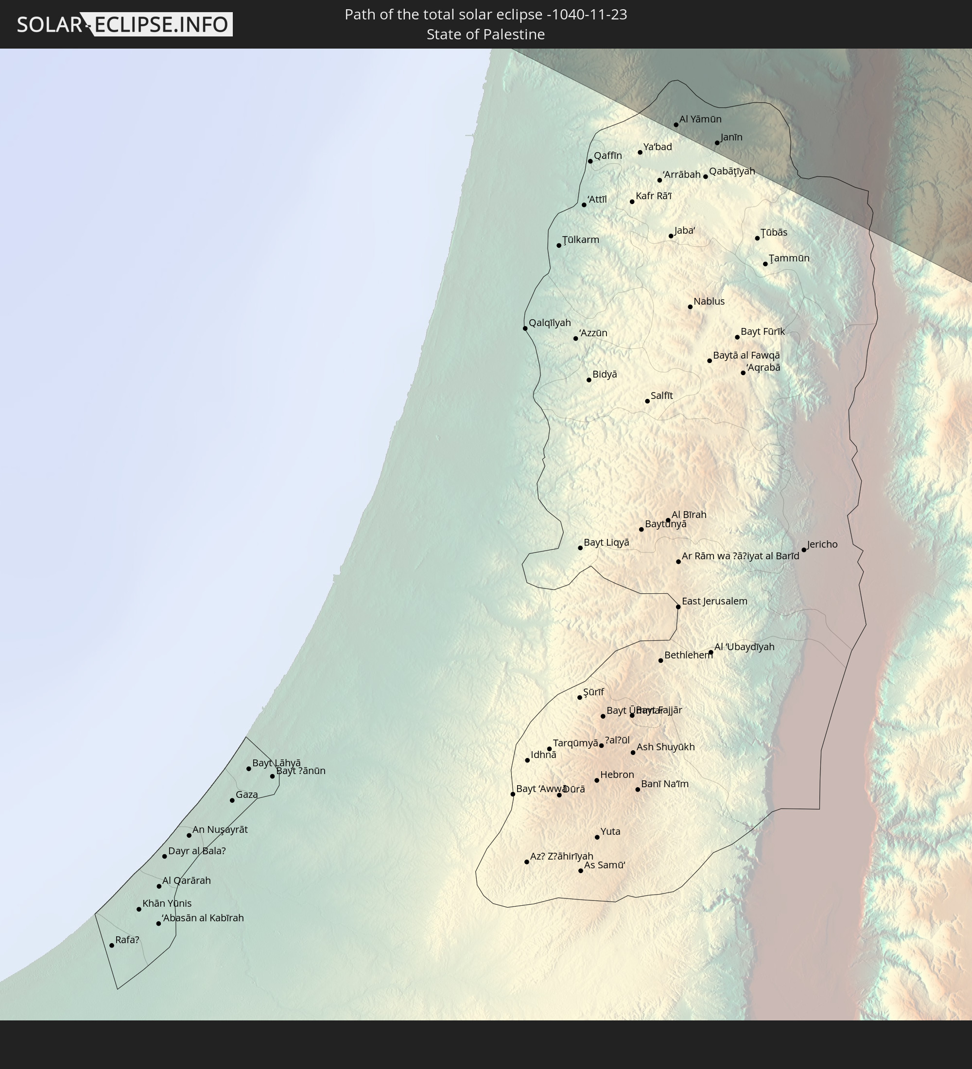 Staat Palästina
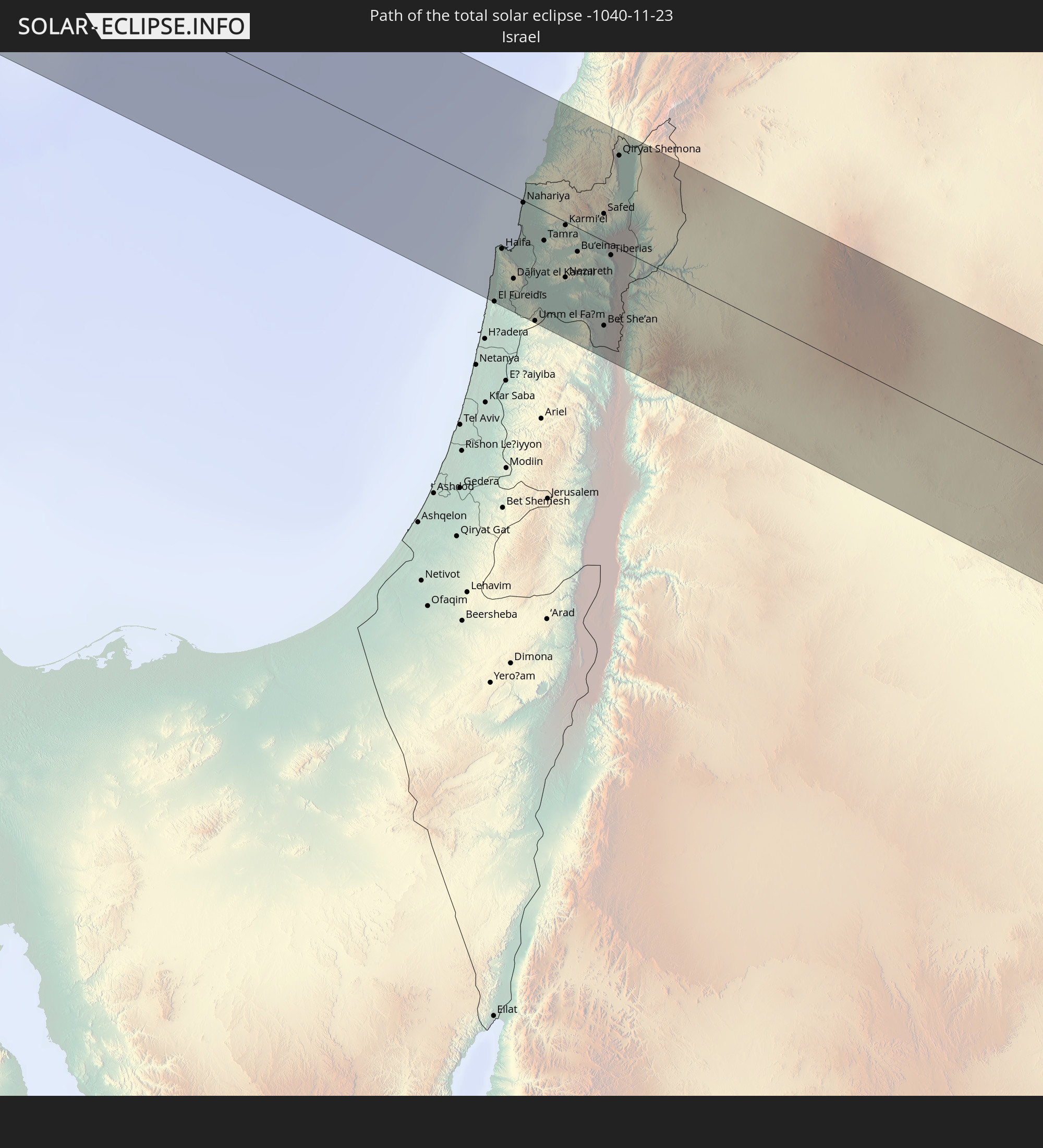 Israel
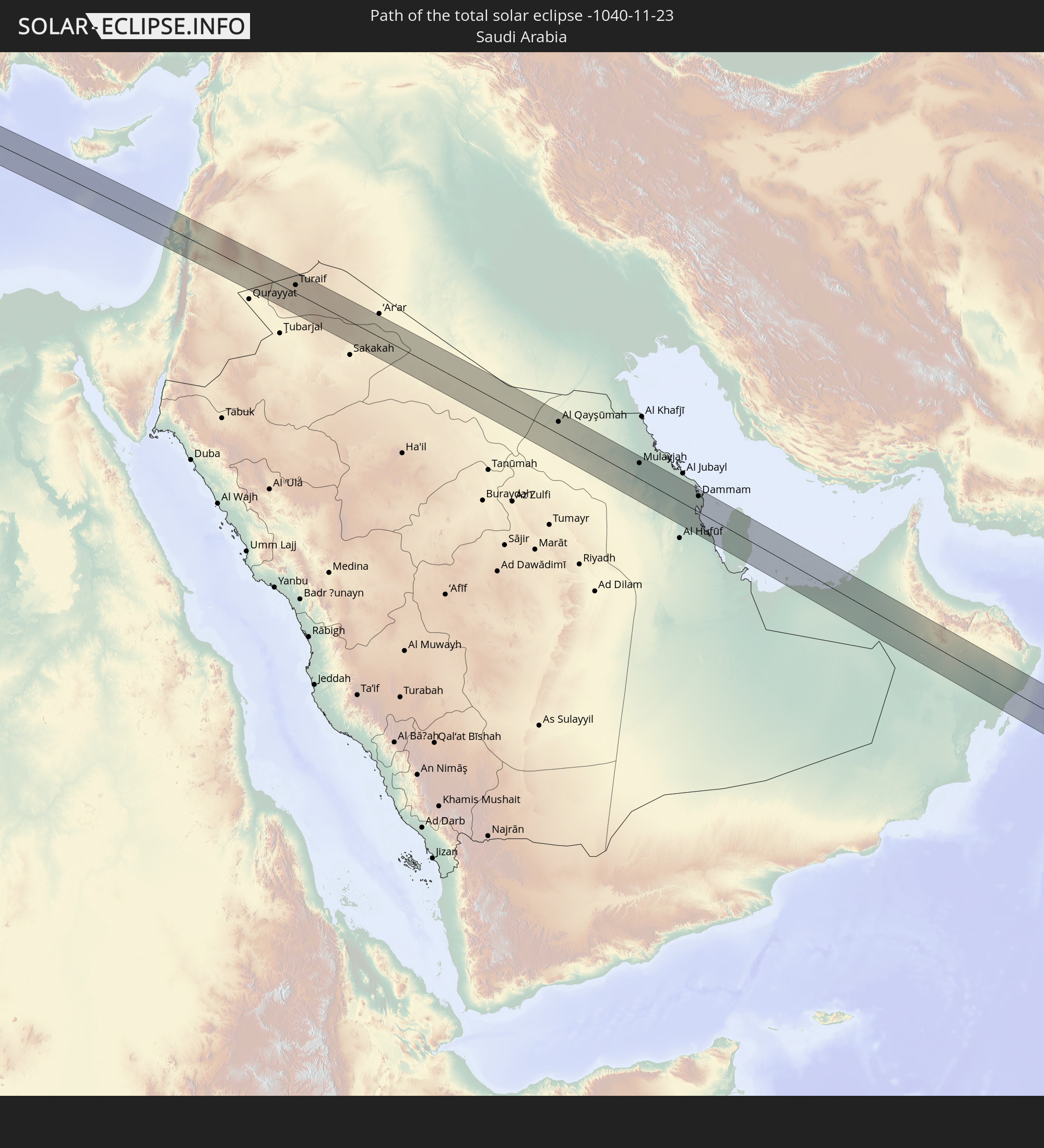 Saudi-Arabien
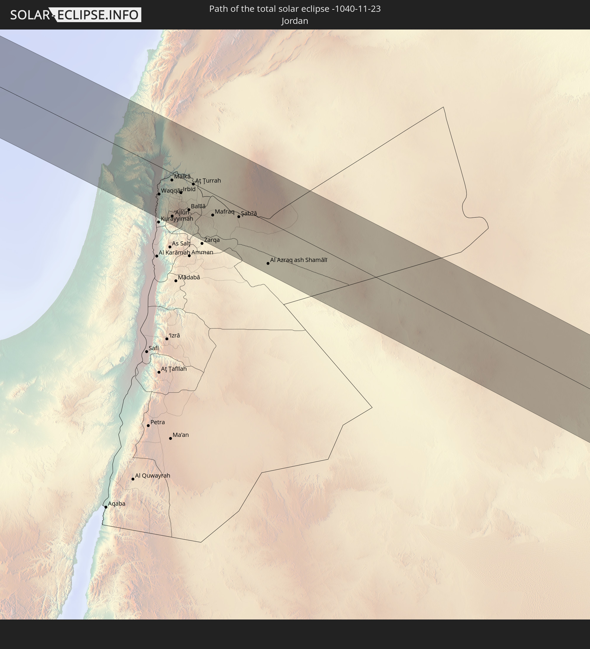 Jordanien
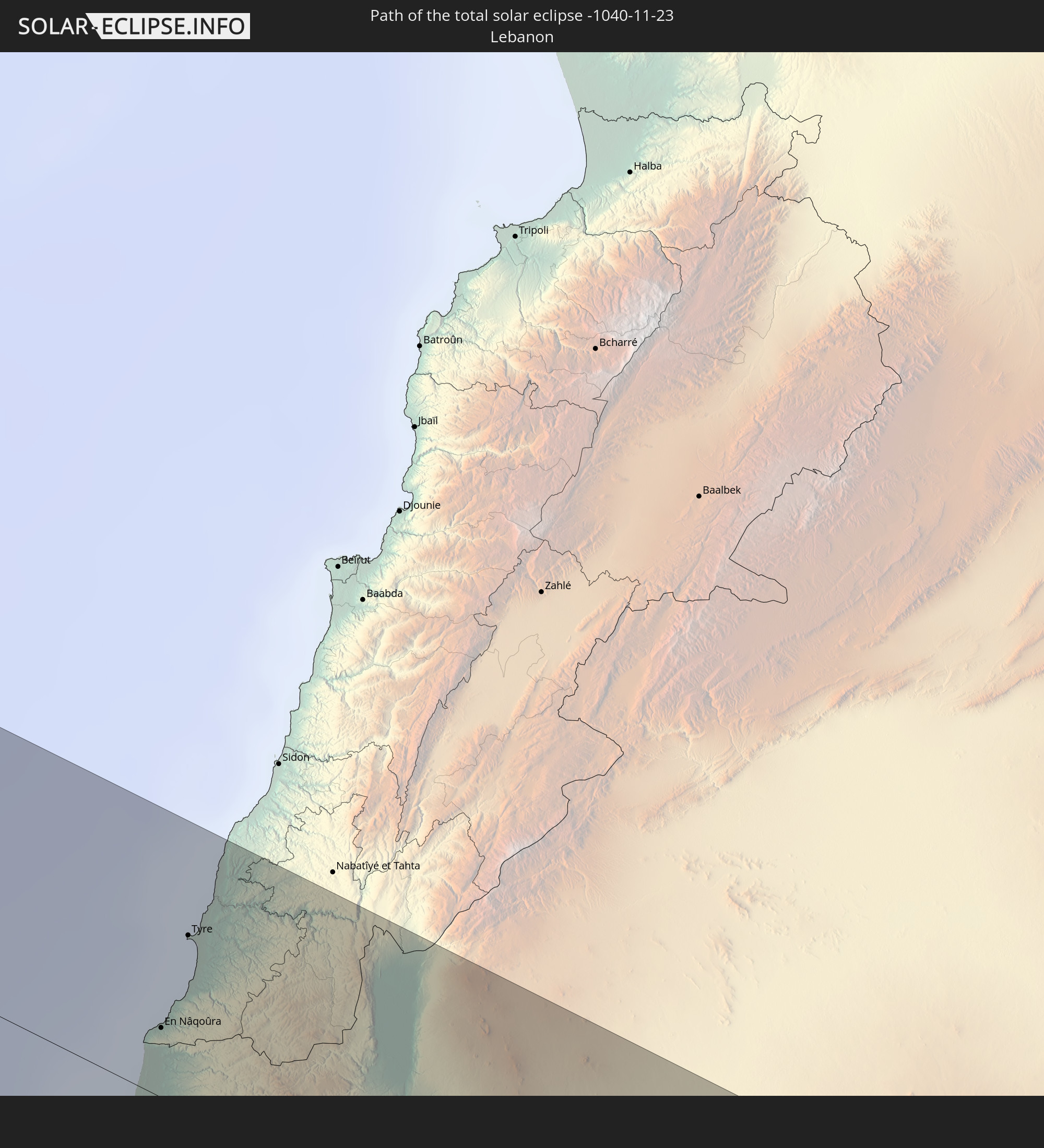 Libanon
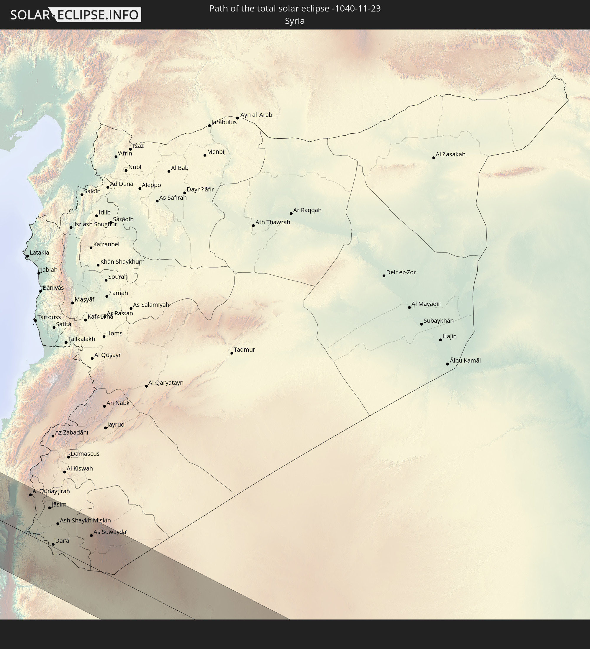 Syrien
 Irak
Irak
 Bahrain
 Katar
Katar
 Vereinigte Arabische Emirate
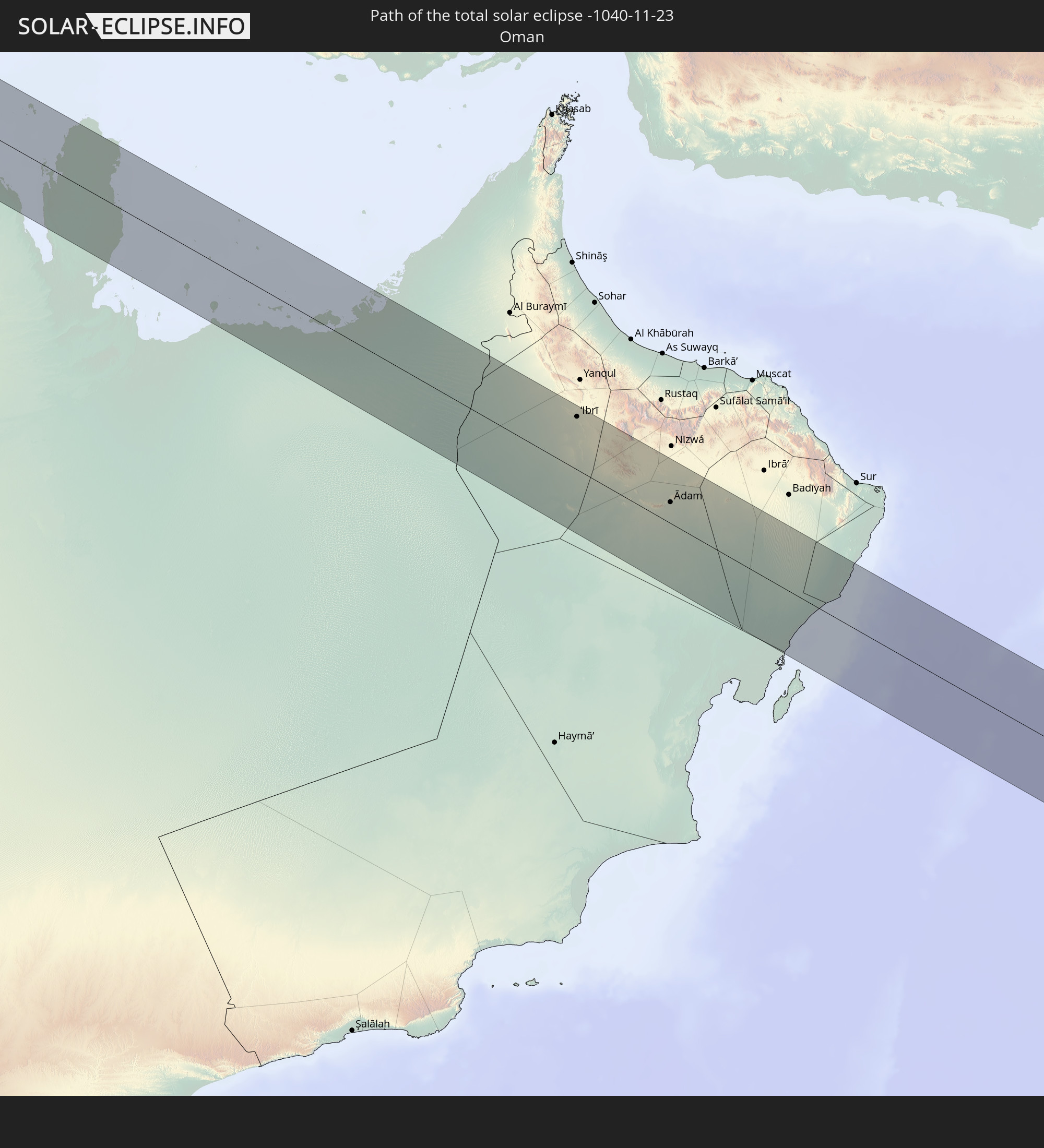 Oman
Oman
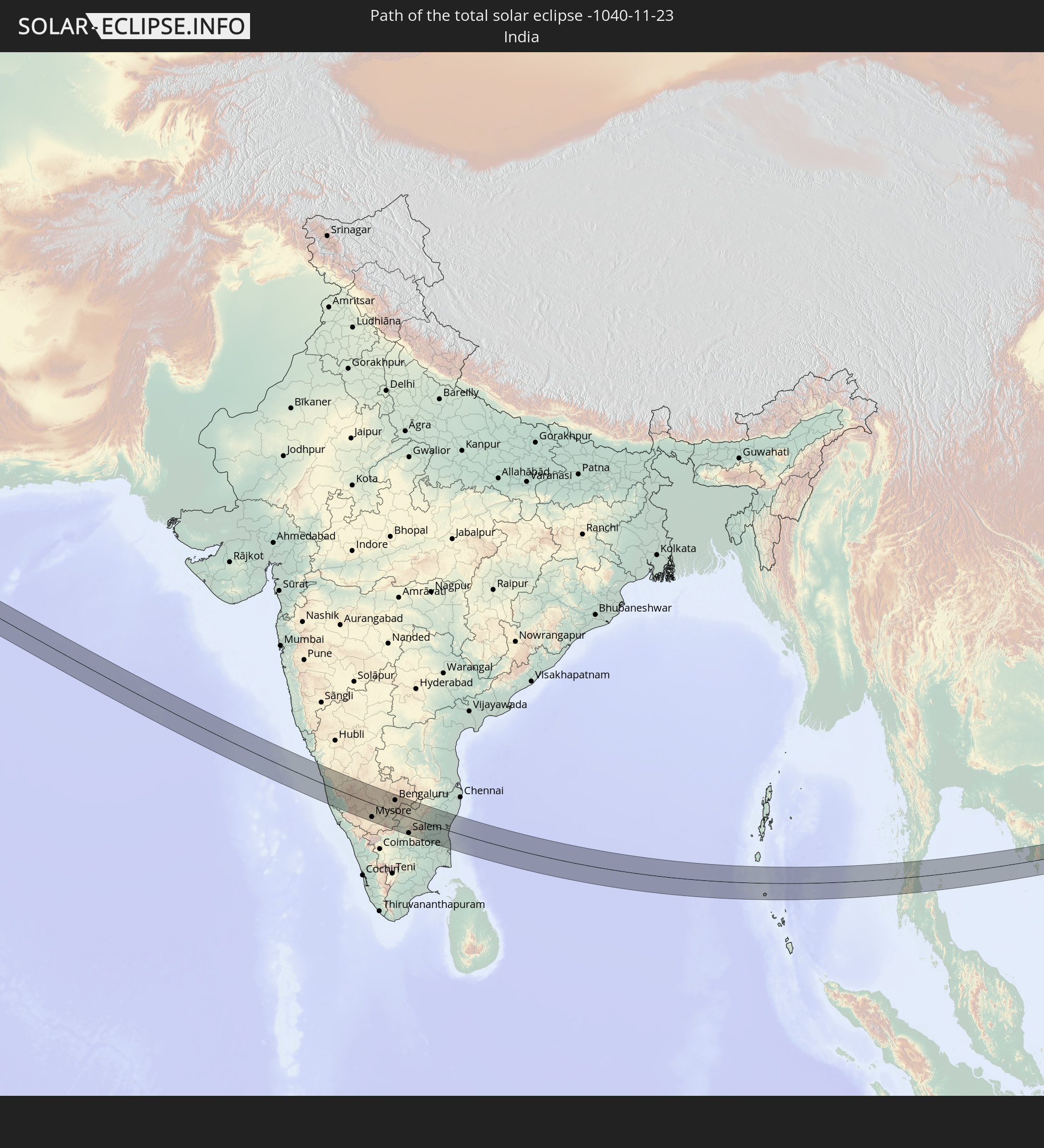 Indien
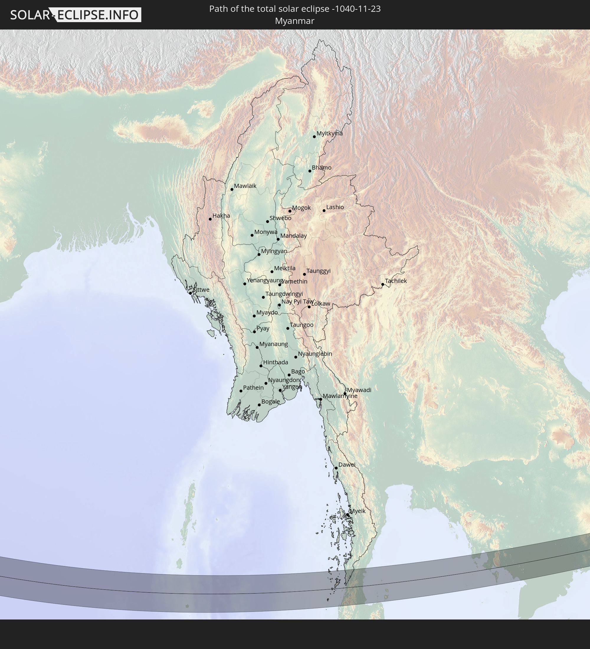 Myanmar
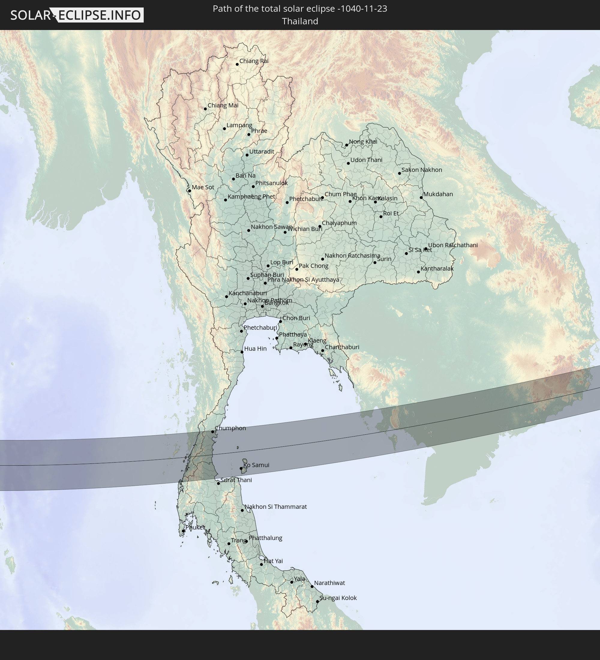 Thailand
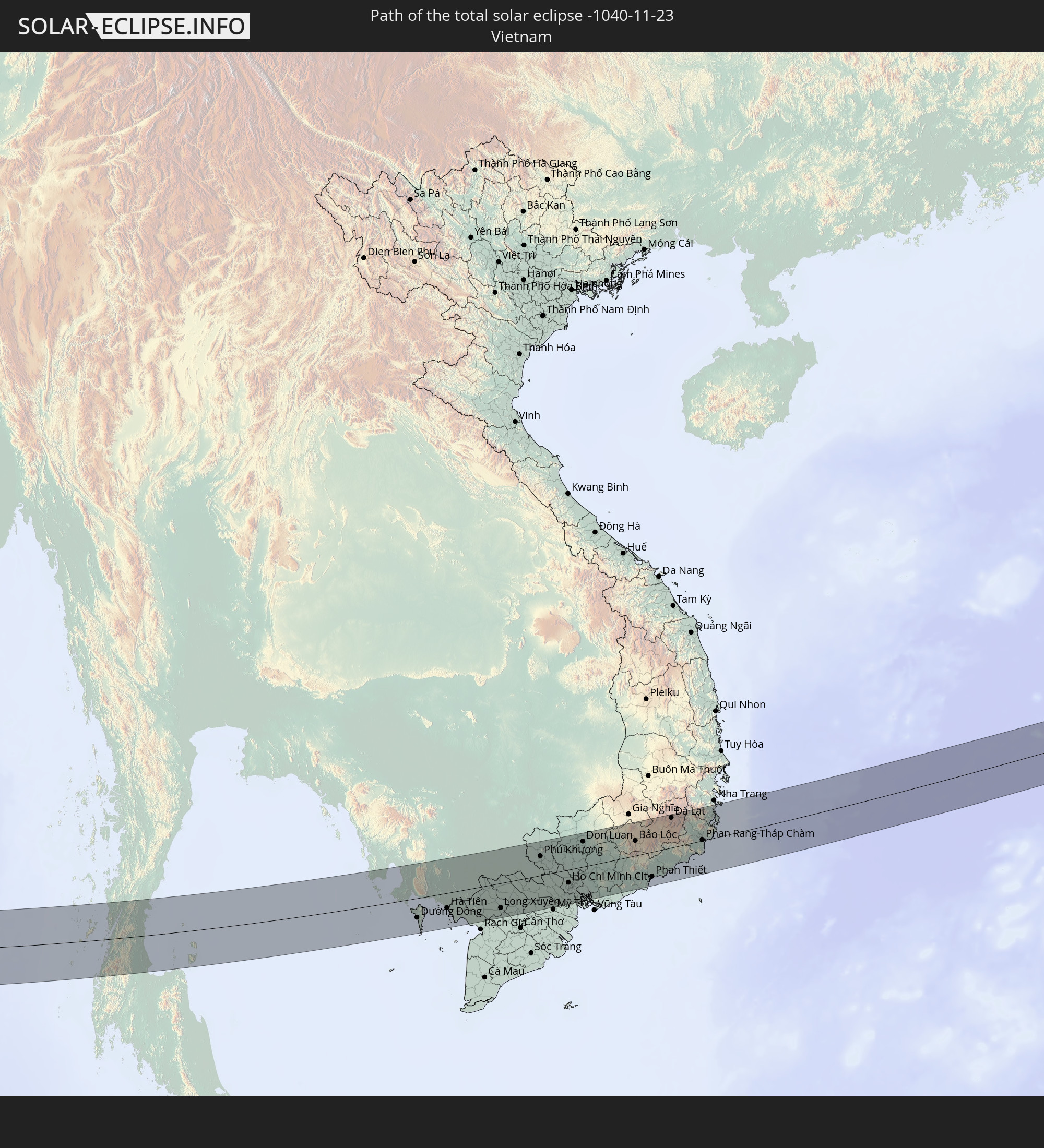 Vietnam
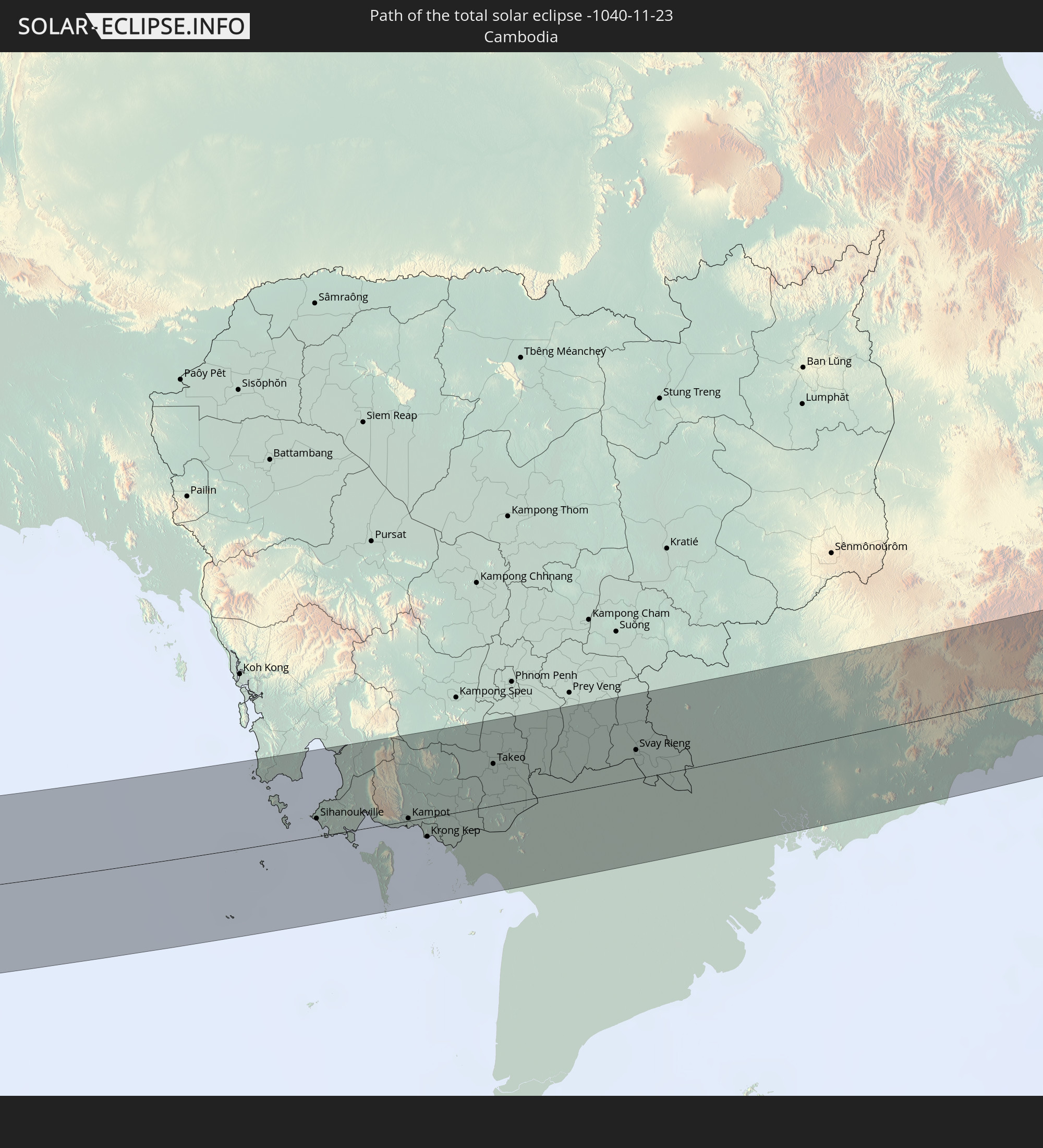 Kambodscha
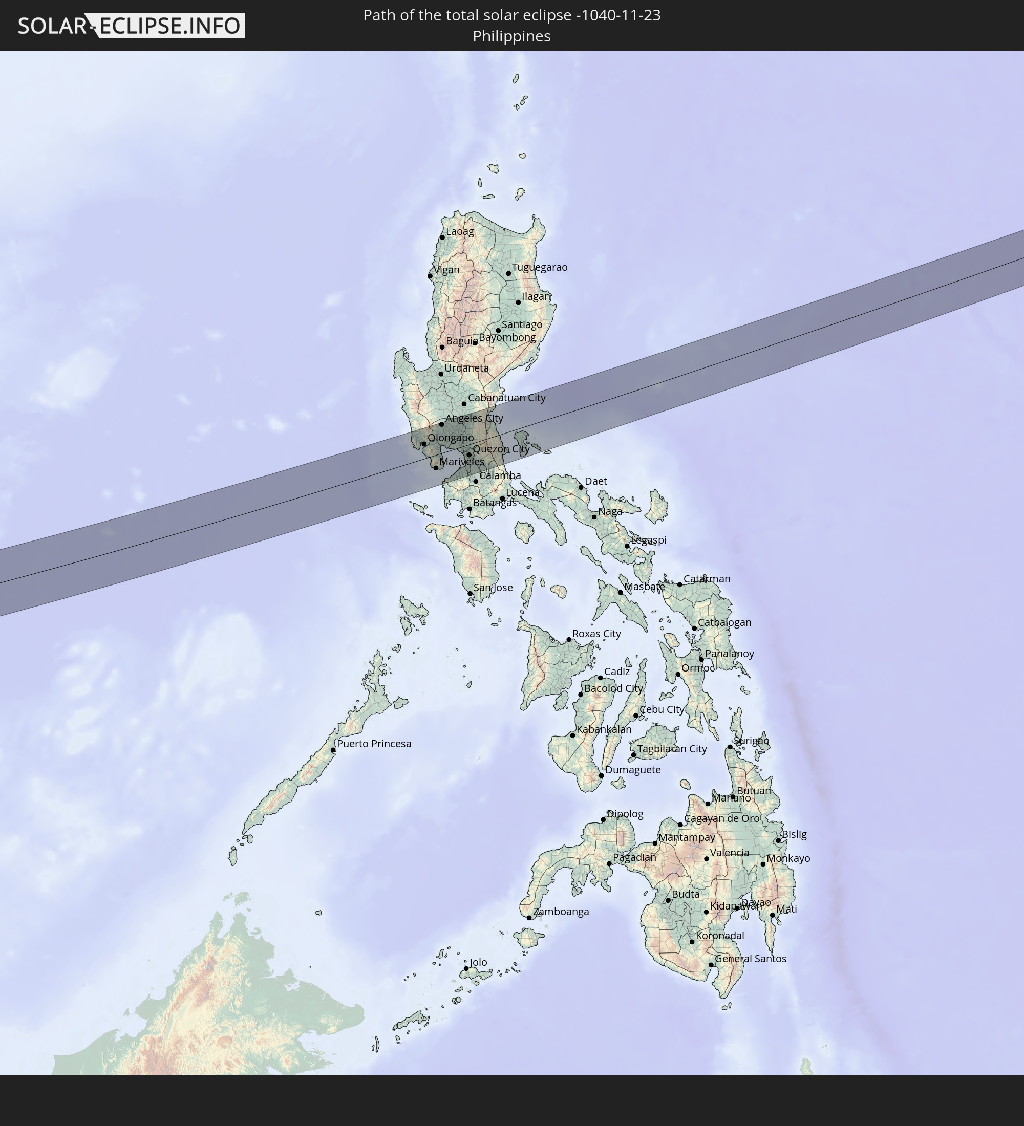 Philippinen
In den folgenden Ländern ist die Sonnenfinsternis partiell zu sehen
 Russland
 Nigeria
 Kamerun
 Libyen
 Demokratische Republik Kongo
 Tschad
 Zentralafrikanische Republik
 Griechenland
 Rumänien
 Sudan
Sudan
 Ukraine
 Bulgarien
 Weißrussland
 Ägypten
 Türkei
 Moldawien
 Tansania
 Uganda
 Republik Zypern
 Äthiopien
 Kenia
Kenia
 Staat Palästina
 Israel
 Saudi-Arabien
 Jordanien
 Libanon
 Syrien
 Eritrea
 Irak
Irak
 Georgien
 Somalia
 Dschibuti
 Jemen
Jemen
 Armenien
 Iran
Iran
 Aserbaidschan
 Seychellen
 Kasachstan
 Kuwait
 Bahrain
 Katar
Katar
 Vereinigte Arabische Emirate
 Oman
Oman
 Turkmenistan
 Usbekistan
 Mauritius
 Afghanistan
 Pakistan
 Tadschikistan
 Indien
 Kirgisistan
 Britisches Territorium im Indischen Ozean
 Malediven
 Volksrepublik China
 Sri Lanka
 Nepal
Nepal
 Mongolei
 Bangladesch
 Bhutan
 Myanmar
 Indonesien
 Kokosinseln
 Thailand
 Malaysia
 Laos
Laos
 Vietnam
 Kambodscha
 Singapur
 Weihnachtsinsel
 Australien
 Macau
Macau
 Hongkong
 Brunei
 Taiwan
 Philippinen
 Japan
Japan
 Osttimor
 Nordkorea
 Südkorea
 Palau
Palau
 Föderierte Staaten von Mikronesien
 Papua-Neuguinea
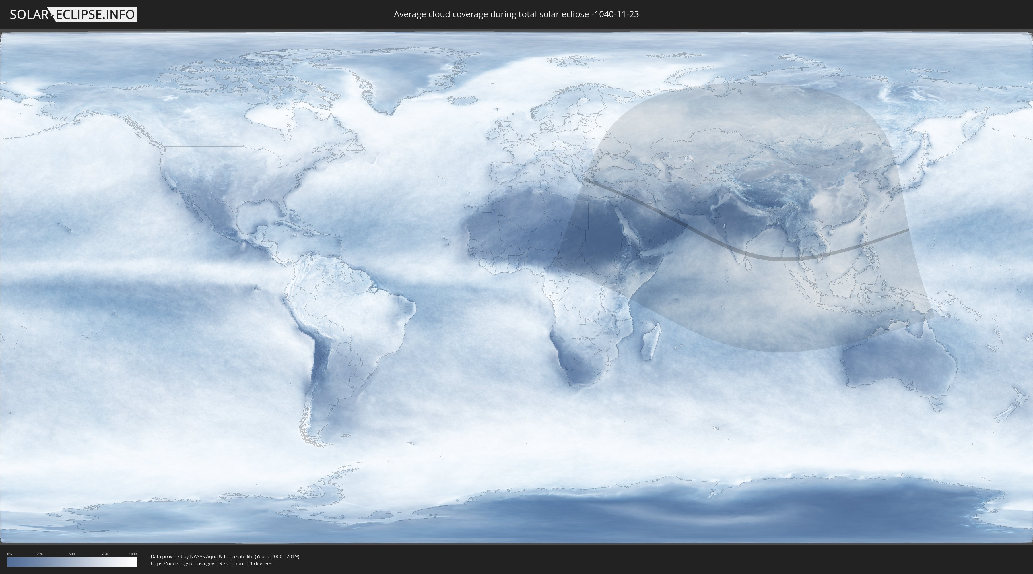
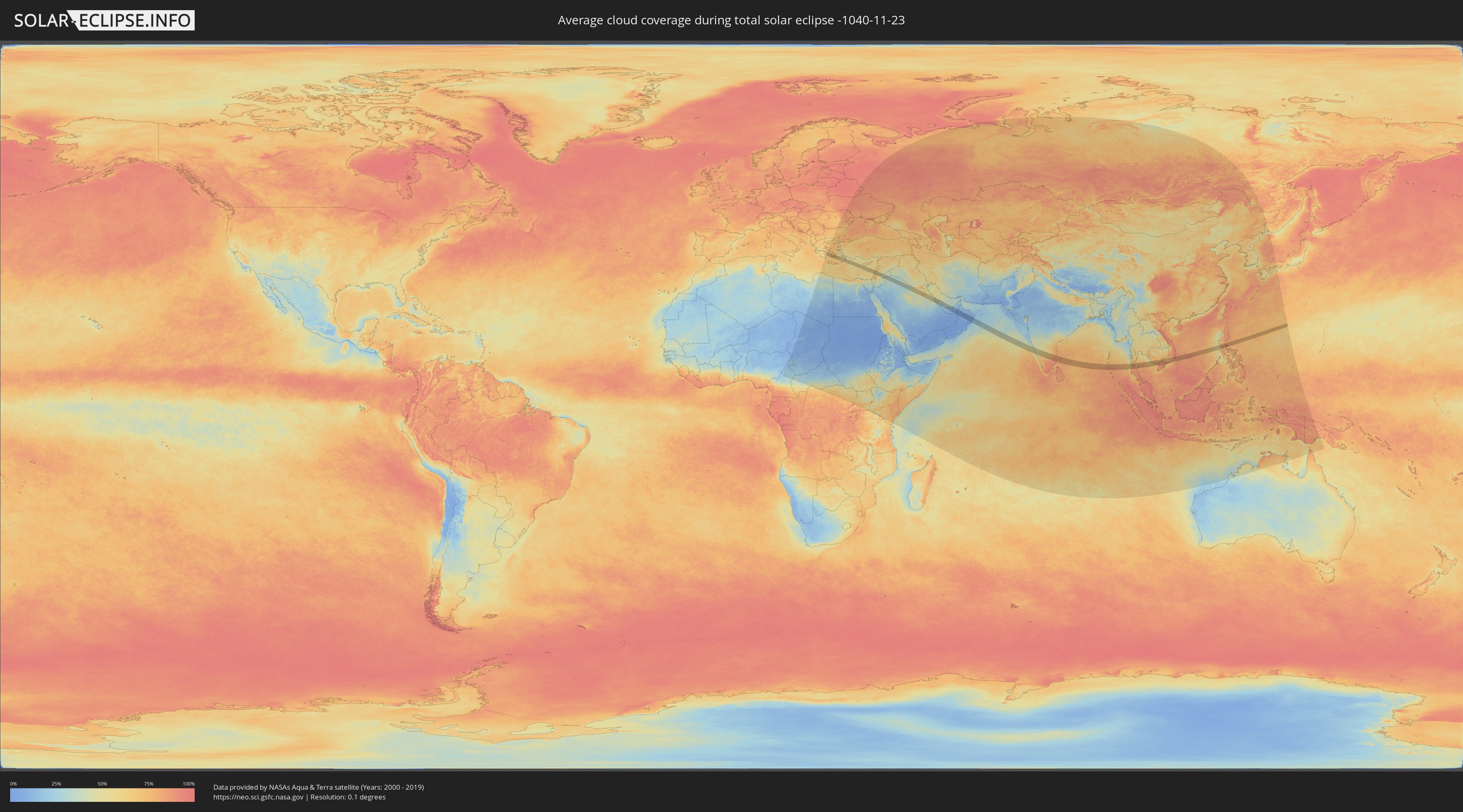
Wie wird das Wetter während der totalen Sonnenfinsternis am 23.11.-1040?
Wo ist der beste Ort, um die totale Sonnenfinsternis vom 23.11.-1040 zu beobachten?
Die folgenden Karten zeigen die durchschnittliche Bewölkung für den Tag, an dem die totale Sonnenfinsternis
stattfindet. Mit Hilfe der Karten lässt sich der Ort entlang des Finsternispfades eingrenzen,
der die besten Aussichen auf einen klaren wolkenfreien Himmel bietet.
Trotzdem muss man immer lokale Gegenenheiten beachten und sollte sich genau über das Wetter an seinem
gewählten Beobachtungsort informieren.
Die Daten stammen von den beiden NASA-Satelliten
AQUA und TERRA
und wurden über einen Zeitraum von 19 Jahren (2000 - 2019) gemittelt.
Detaillierte Länderkarten
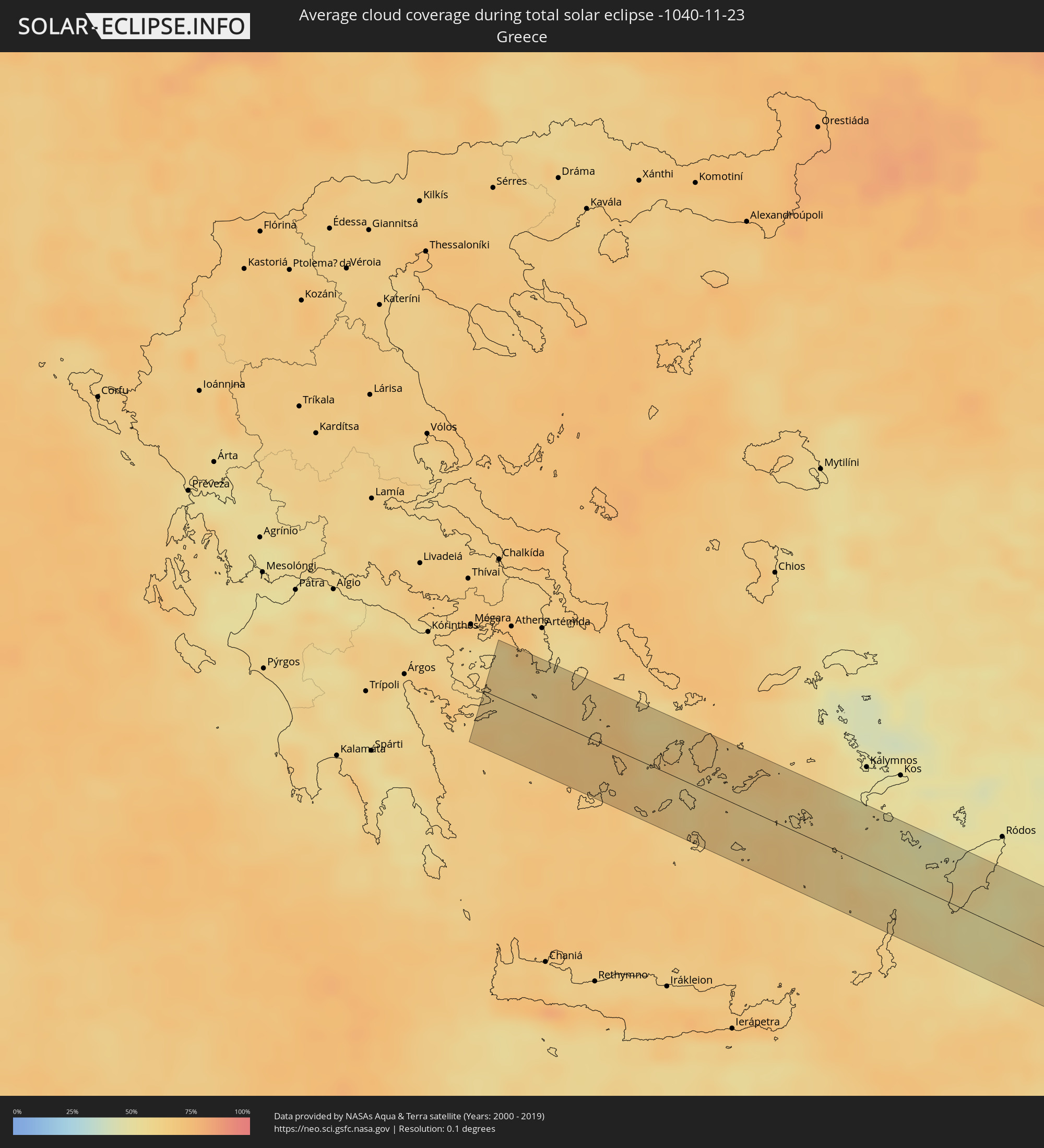 Griechenland
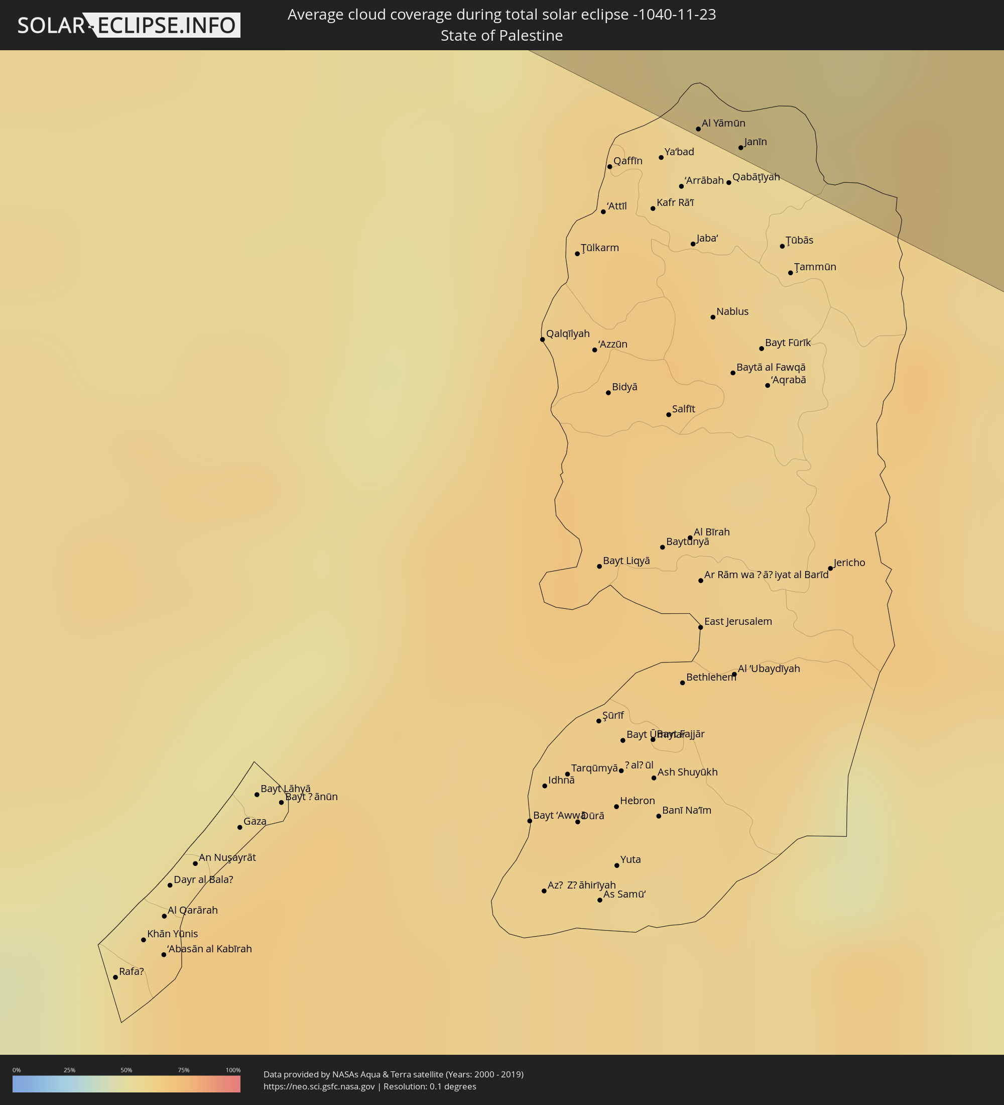 Staat Palästina
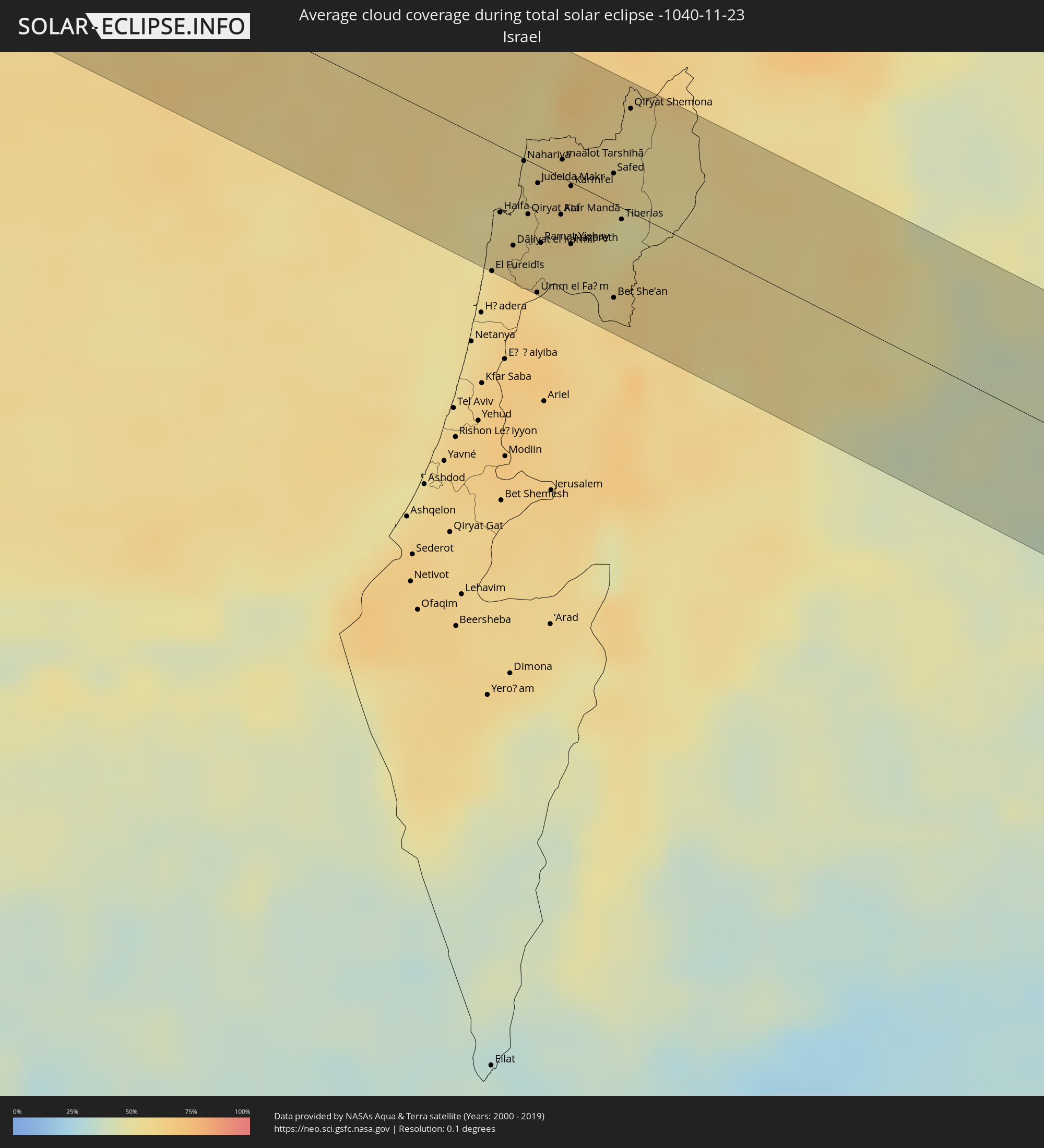 Israel
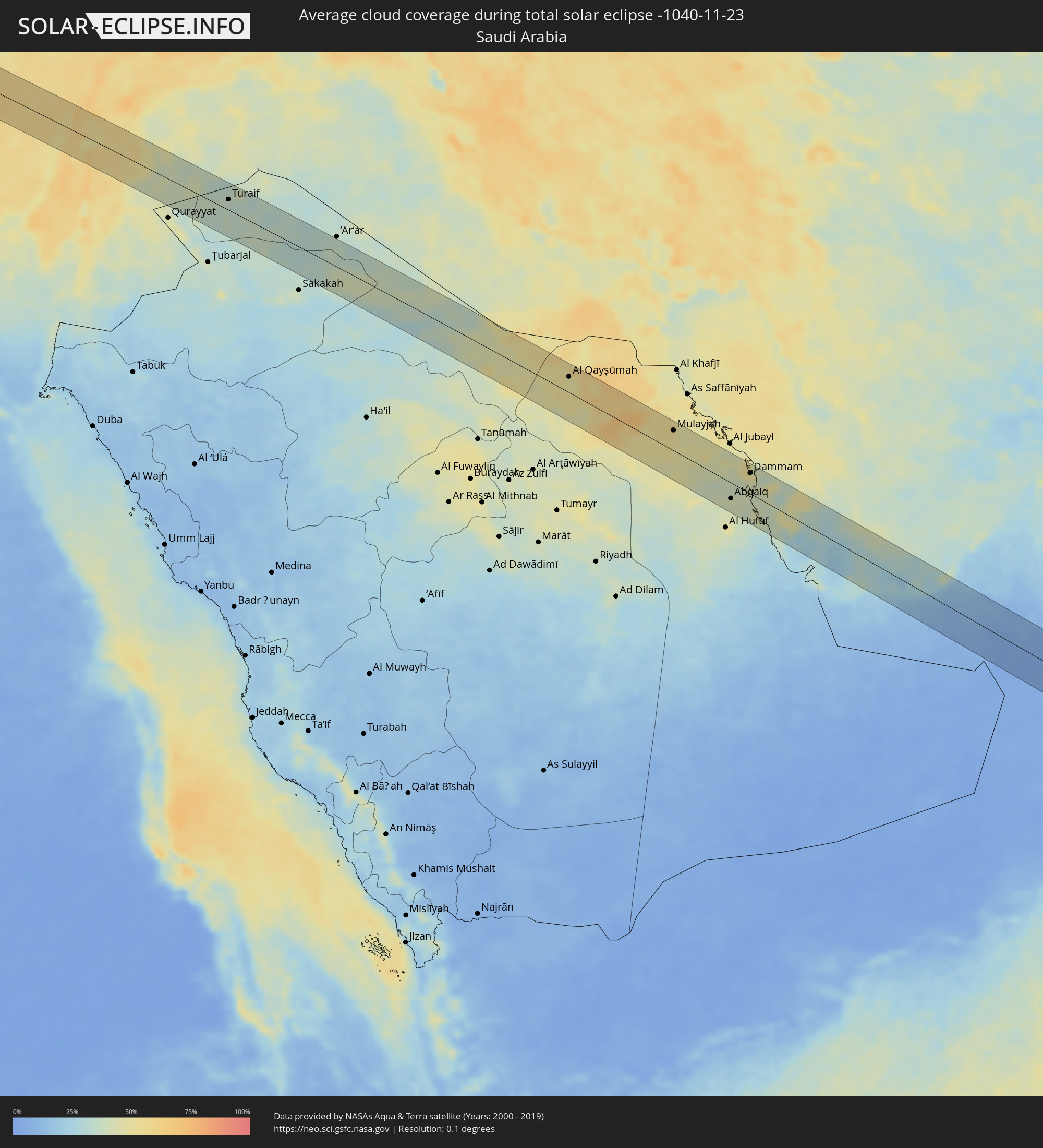 Saudi-Arabien
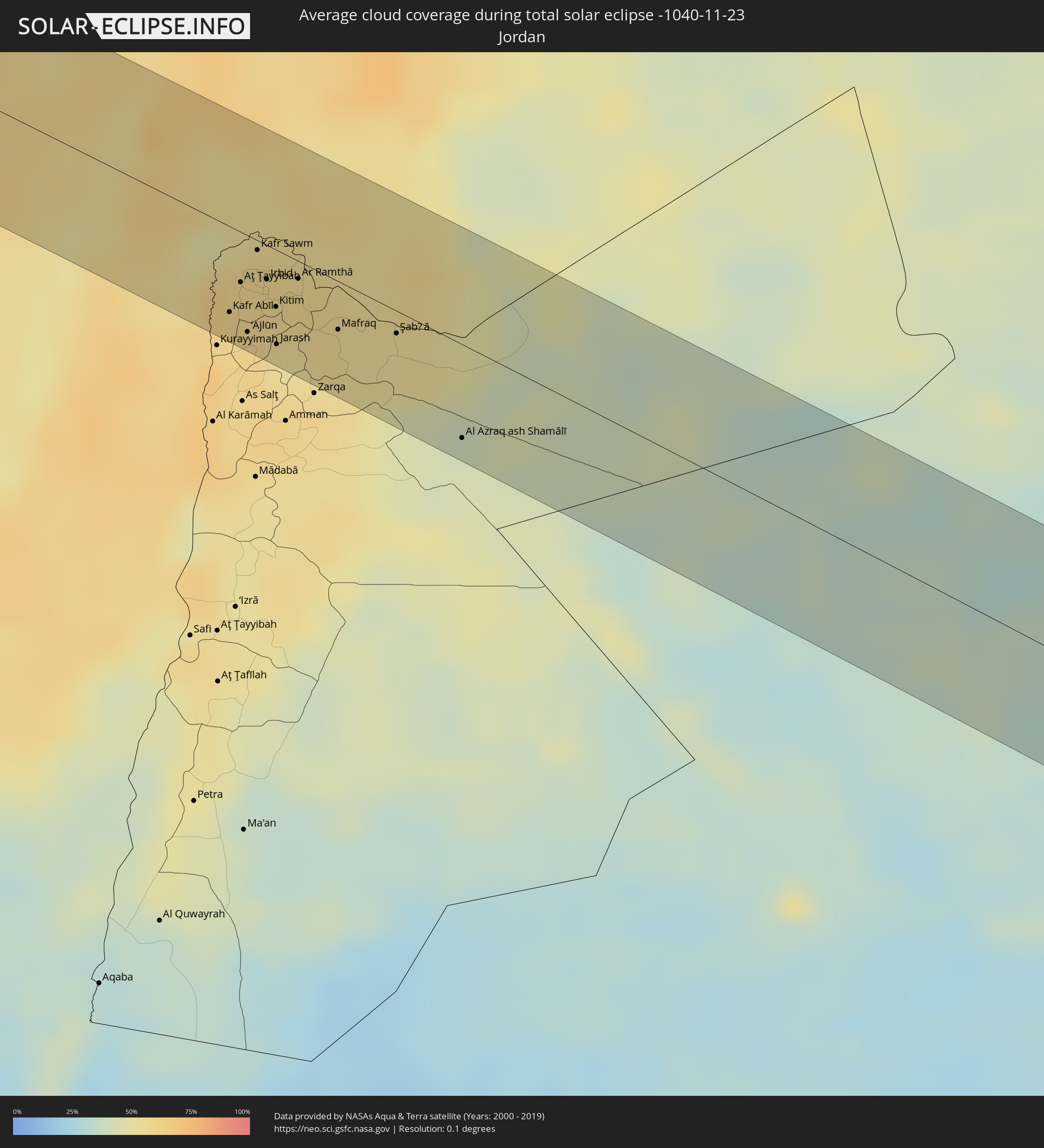 Jordanien
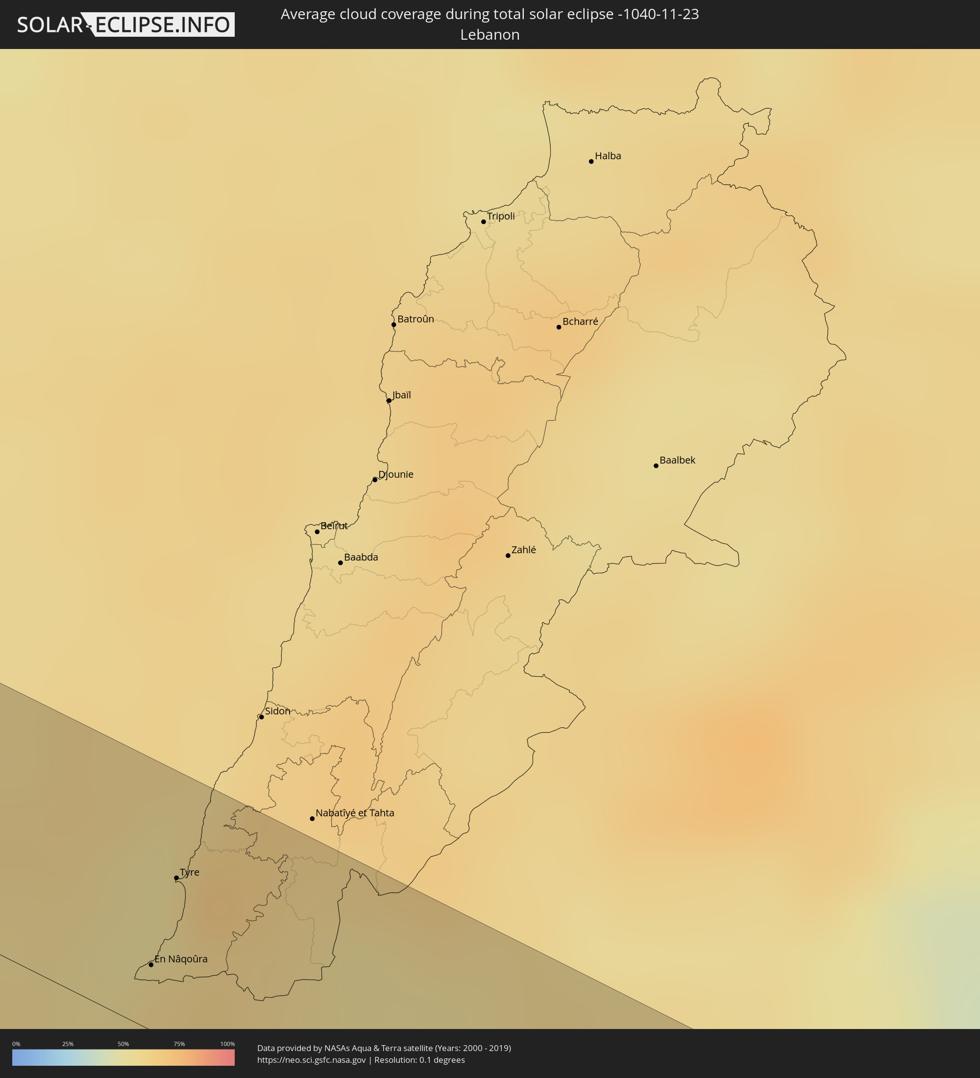 Libanon
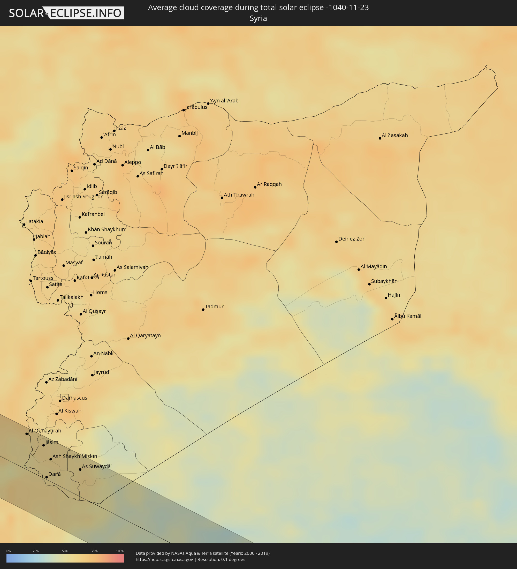 Syrien
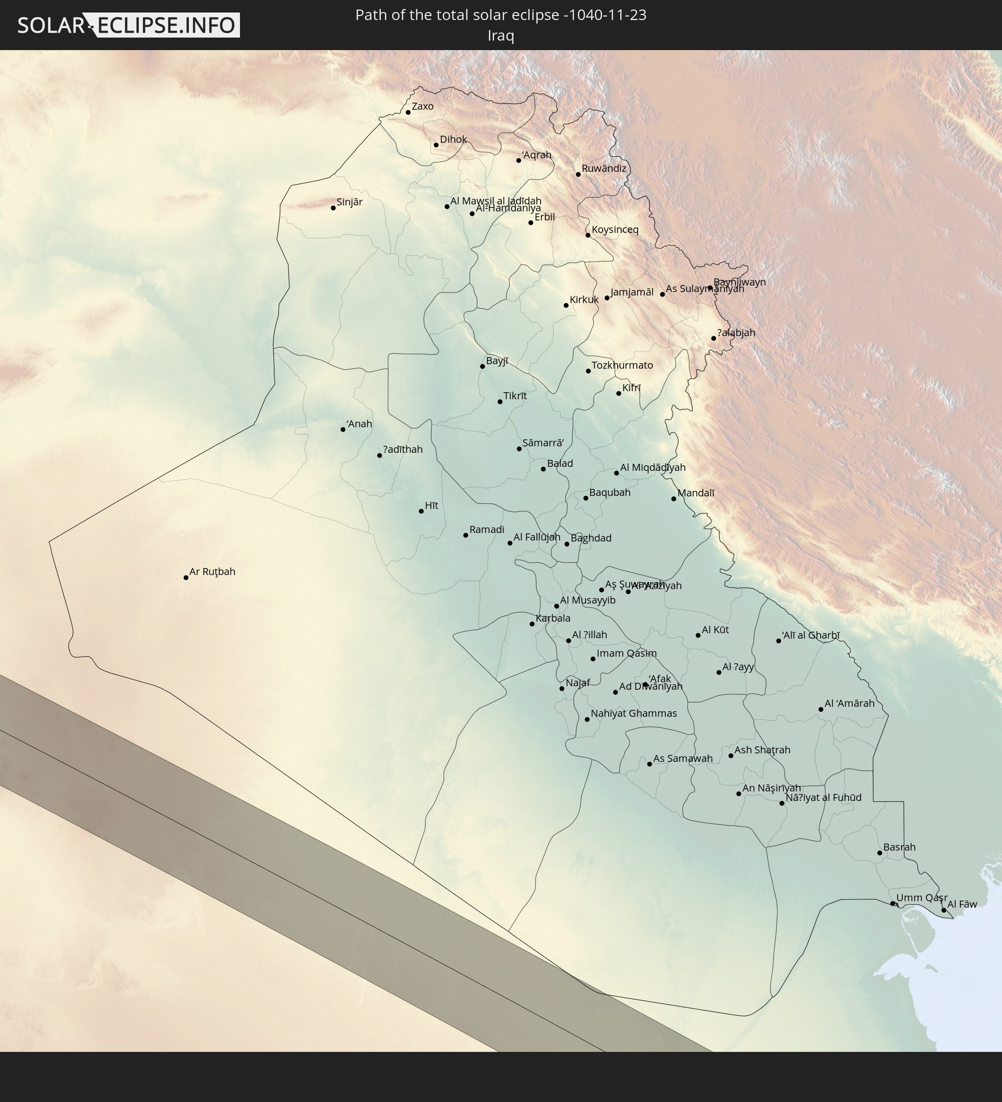
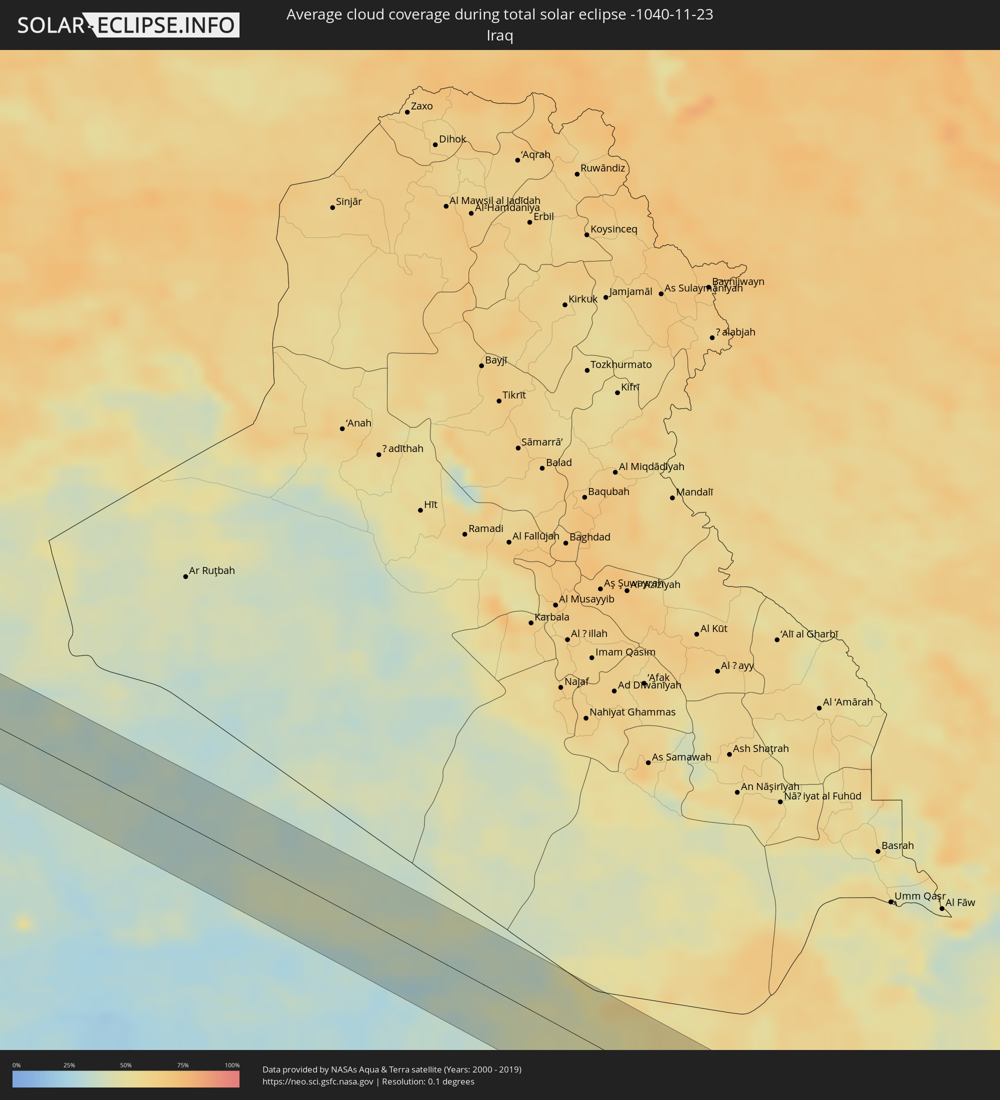 Irak
Irak
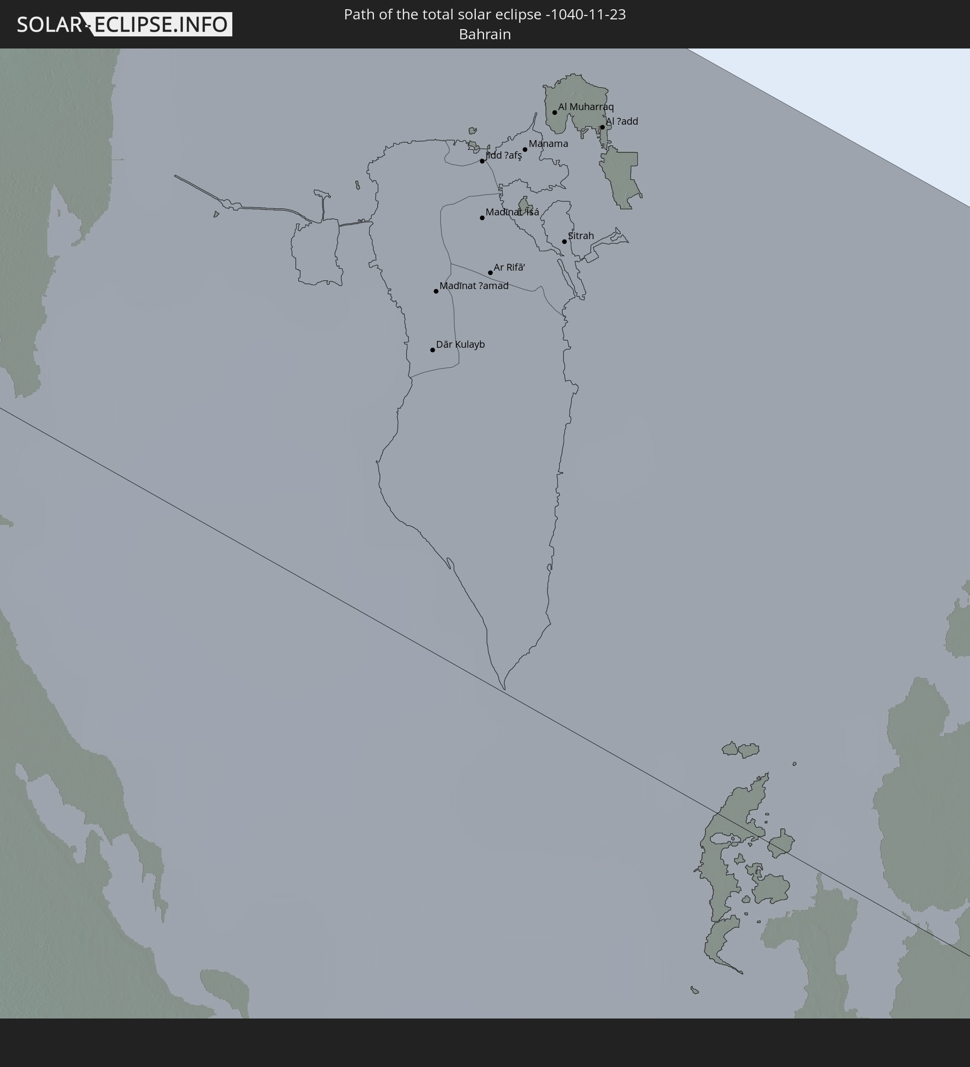
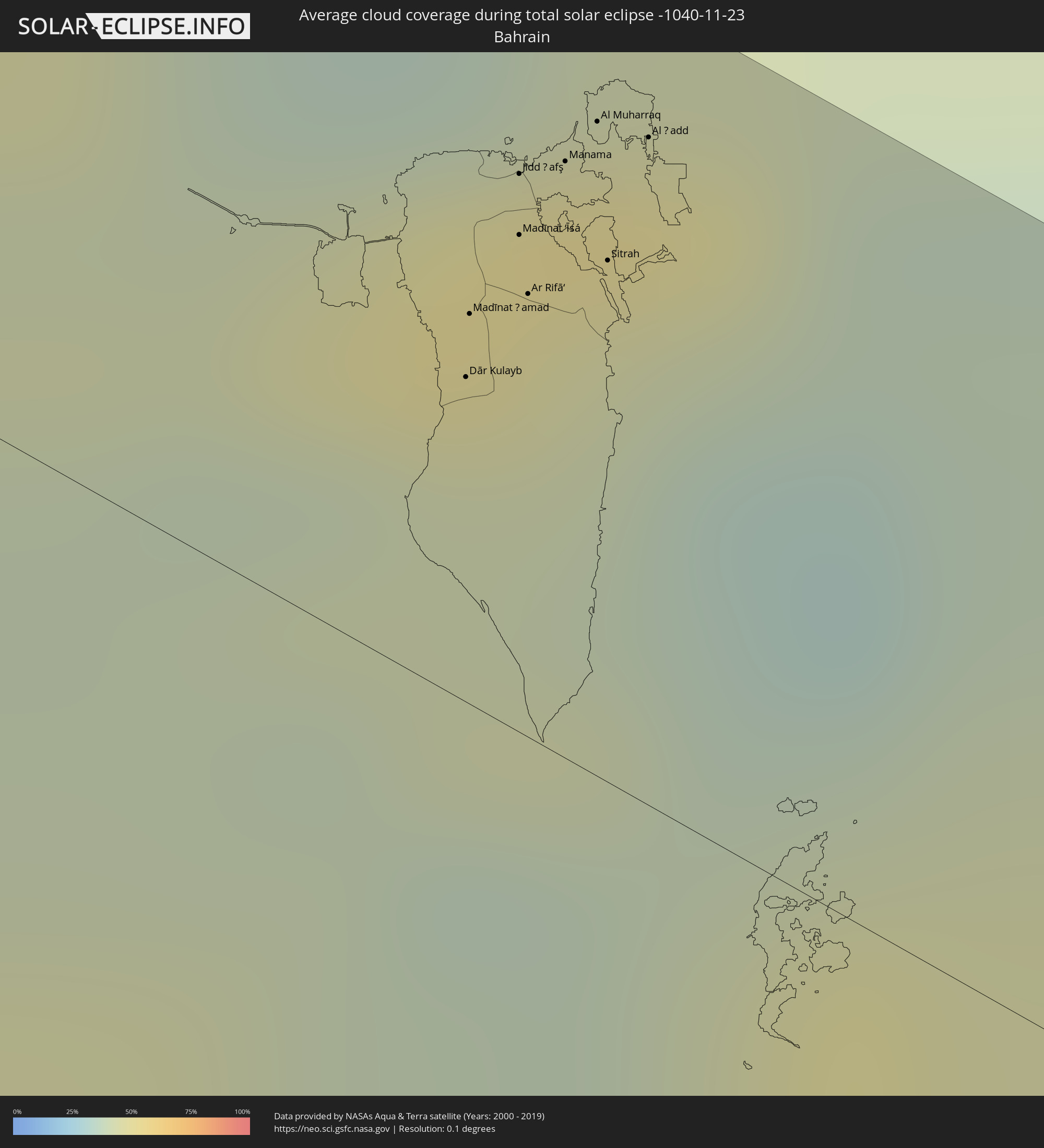 Bahrain
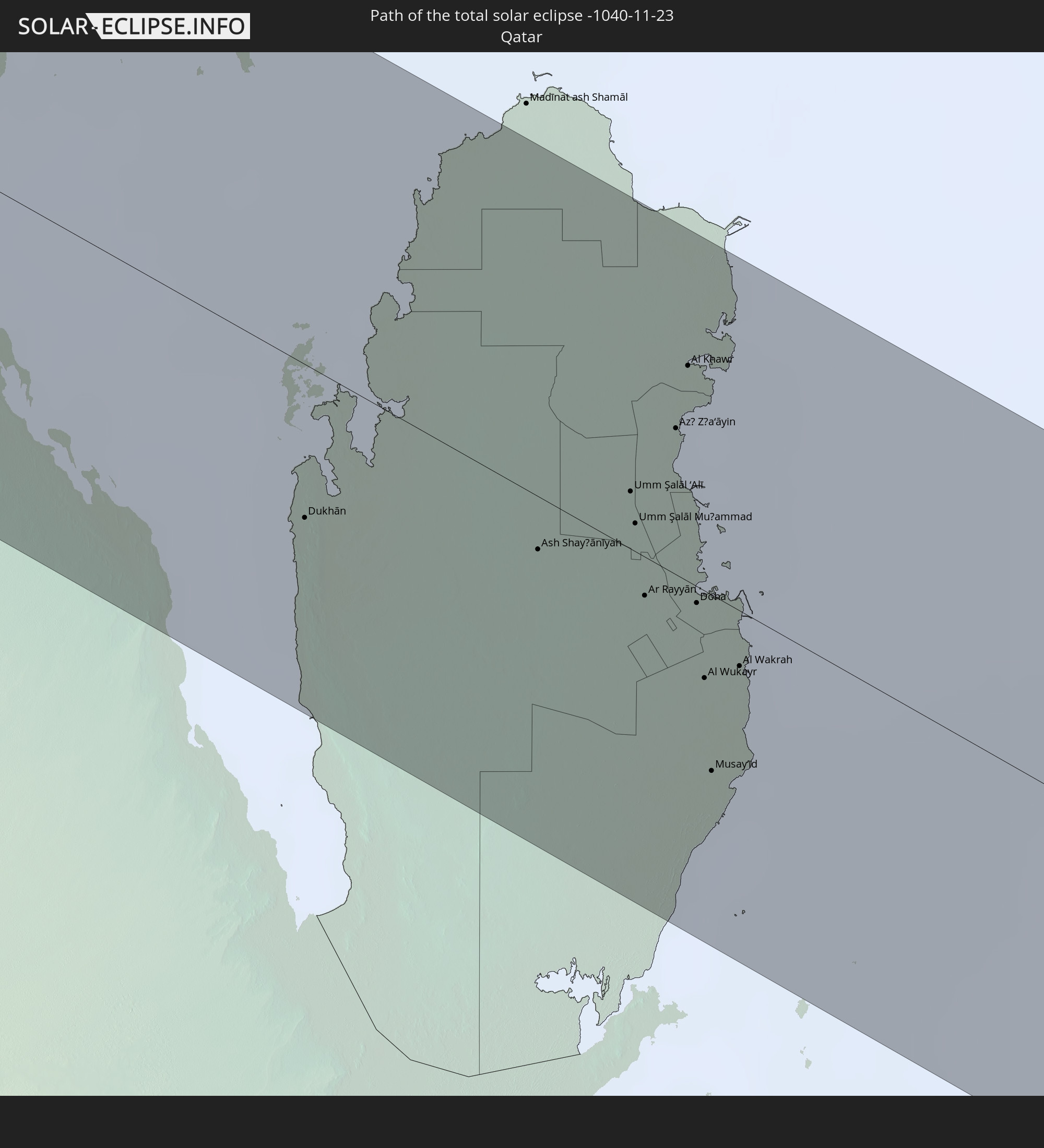
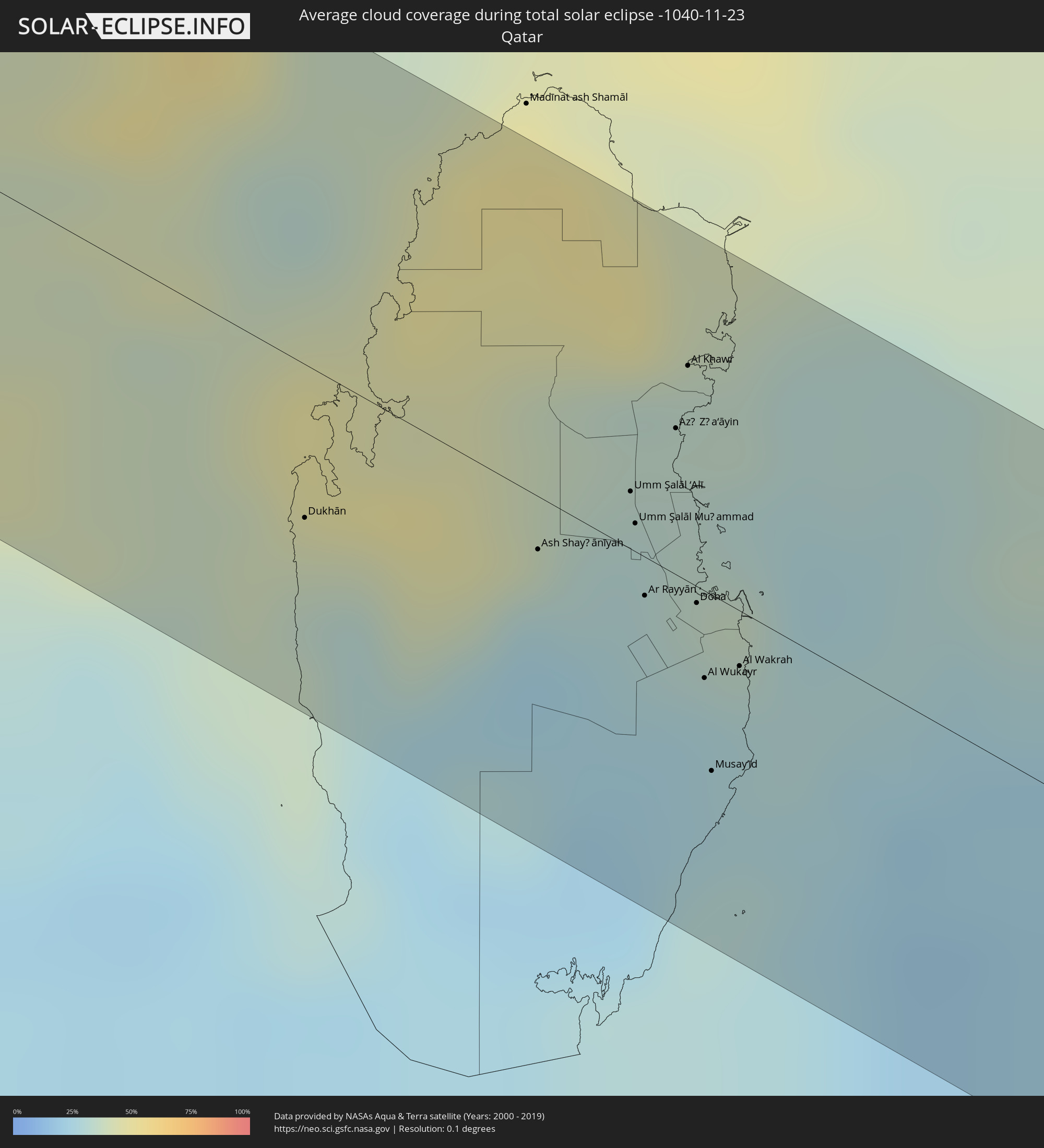 Katar
Katar
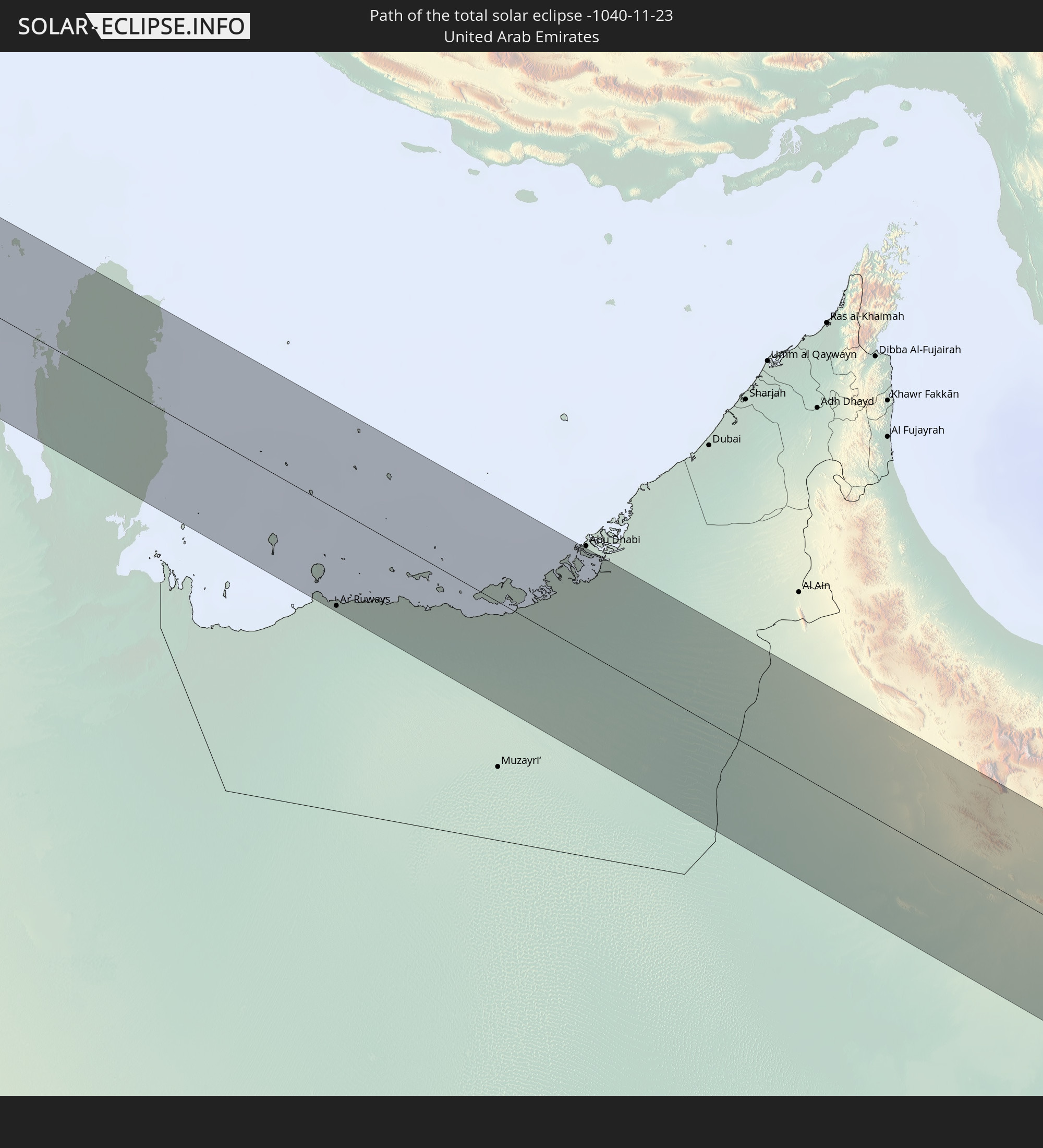
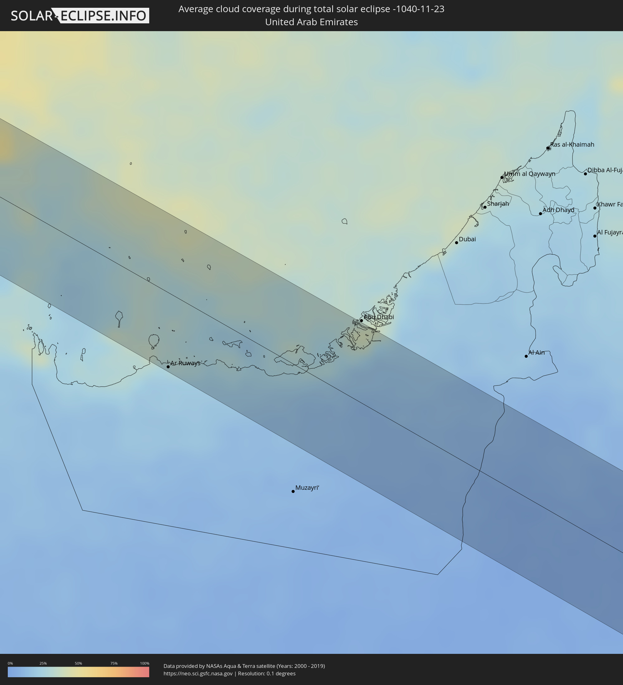 Vereinigte Arabische Emirate
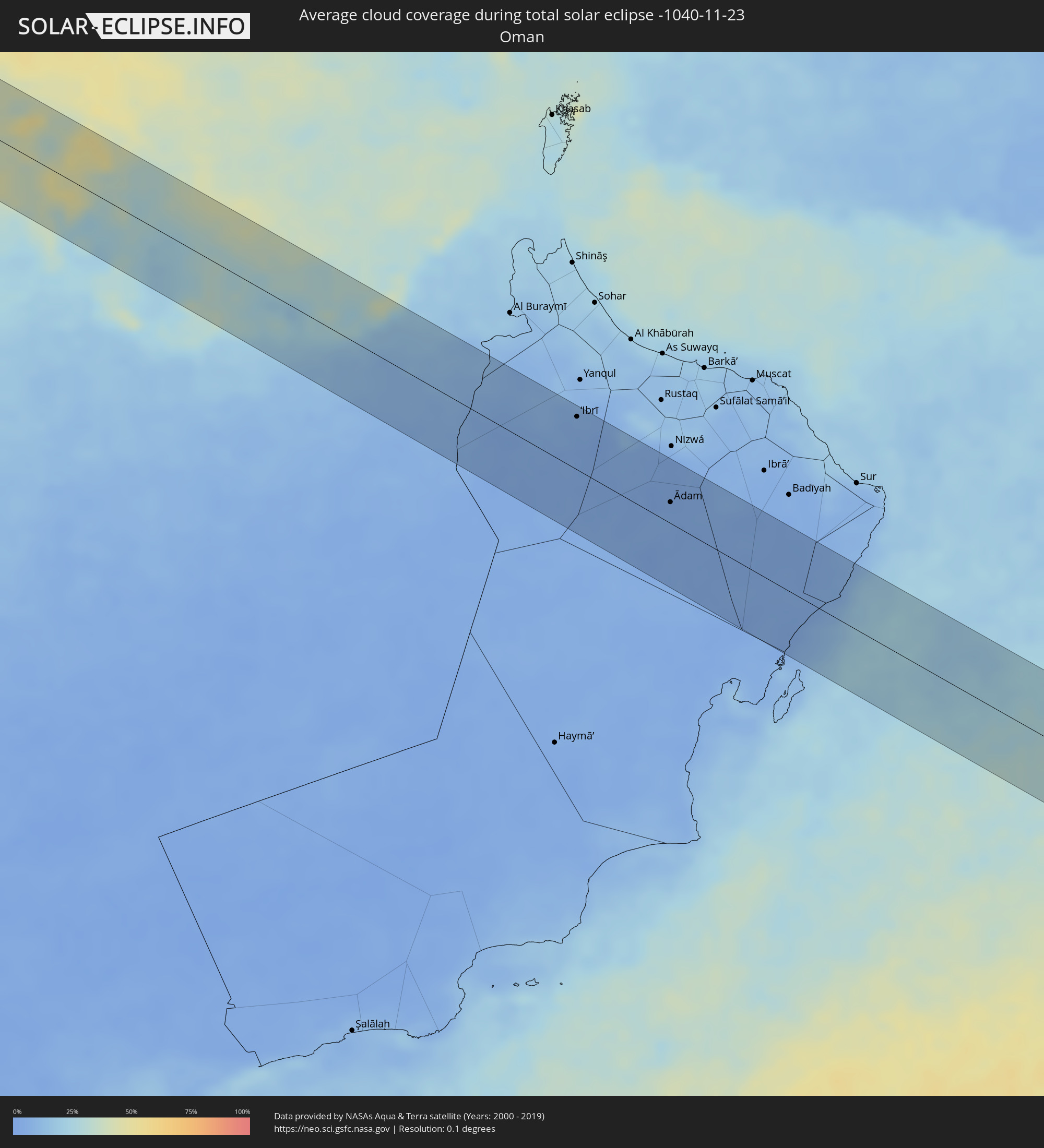 Oman
Oman
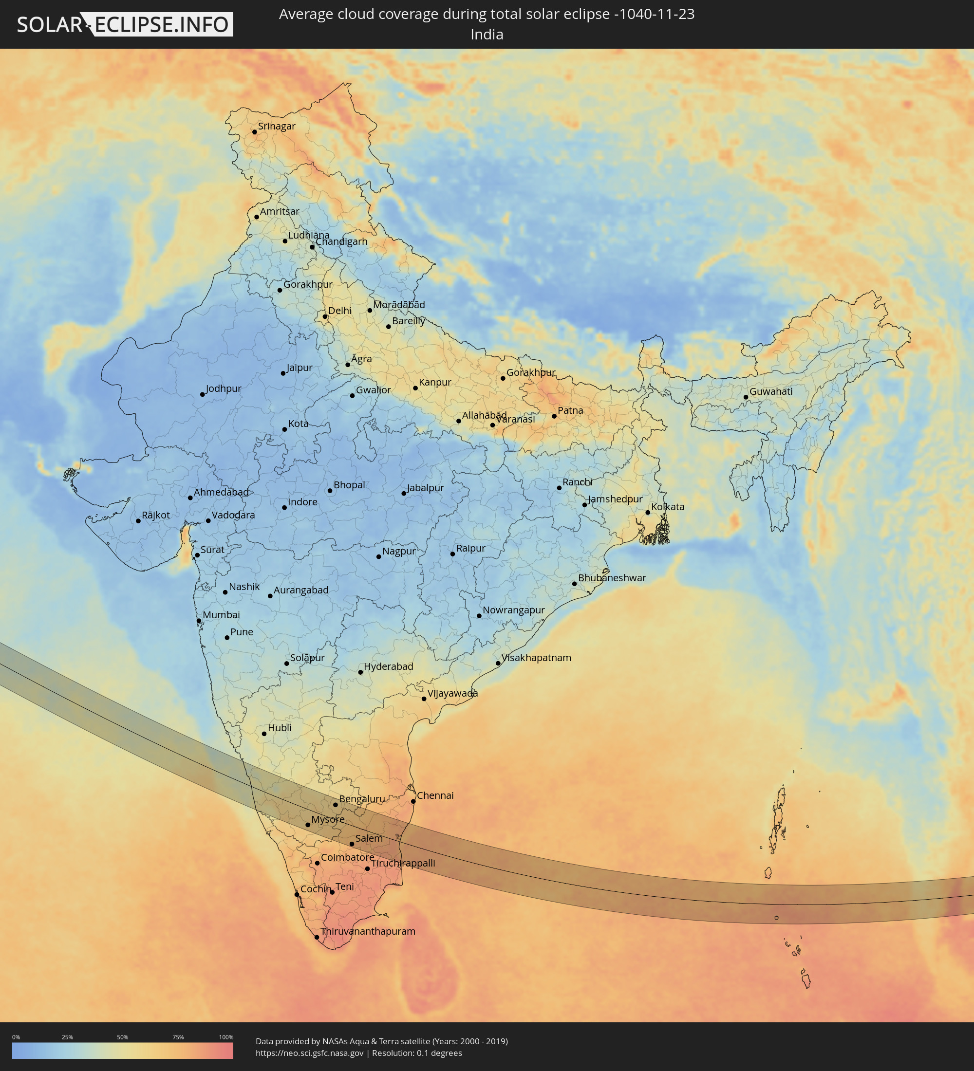 Indien
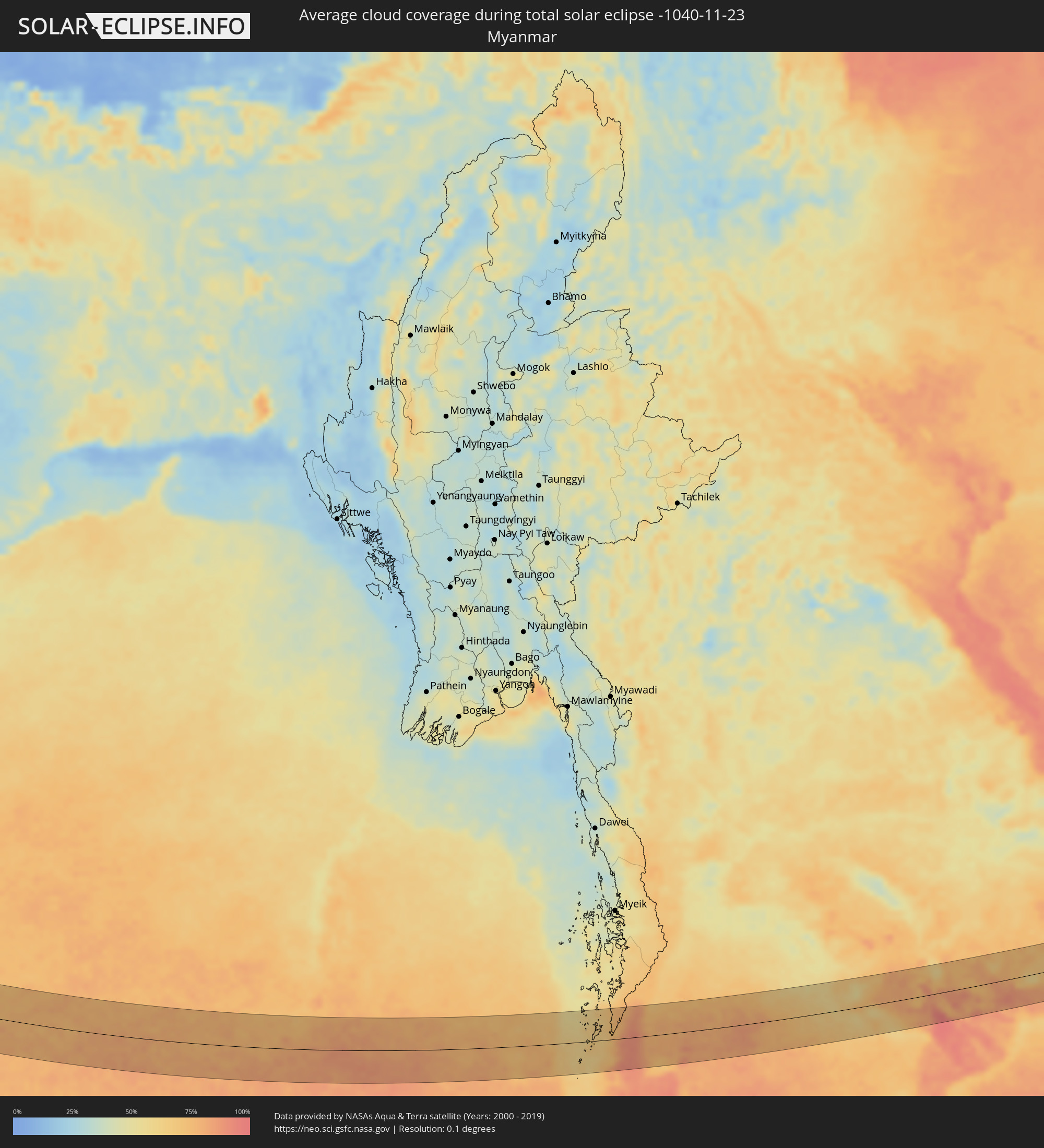 Myanmar
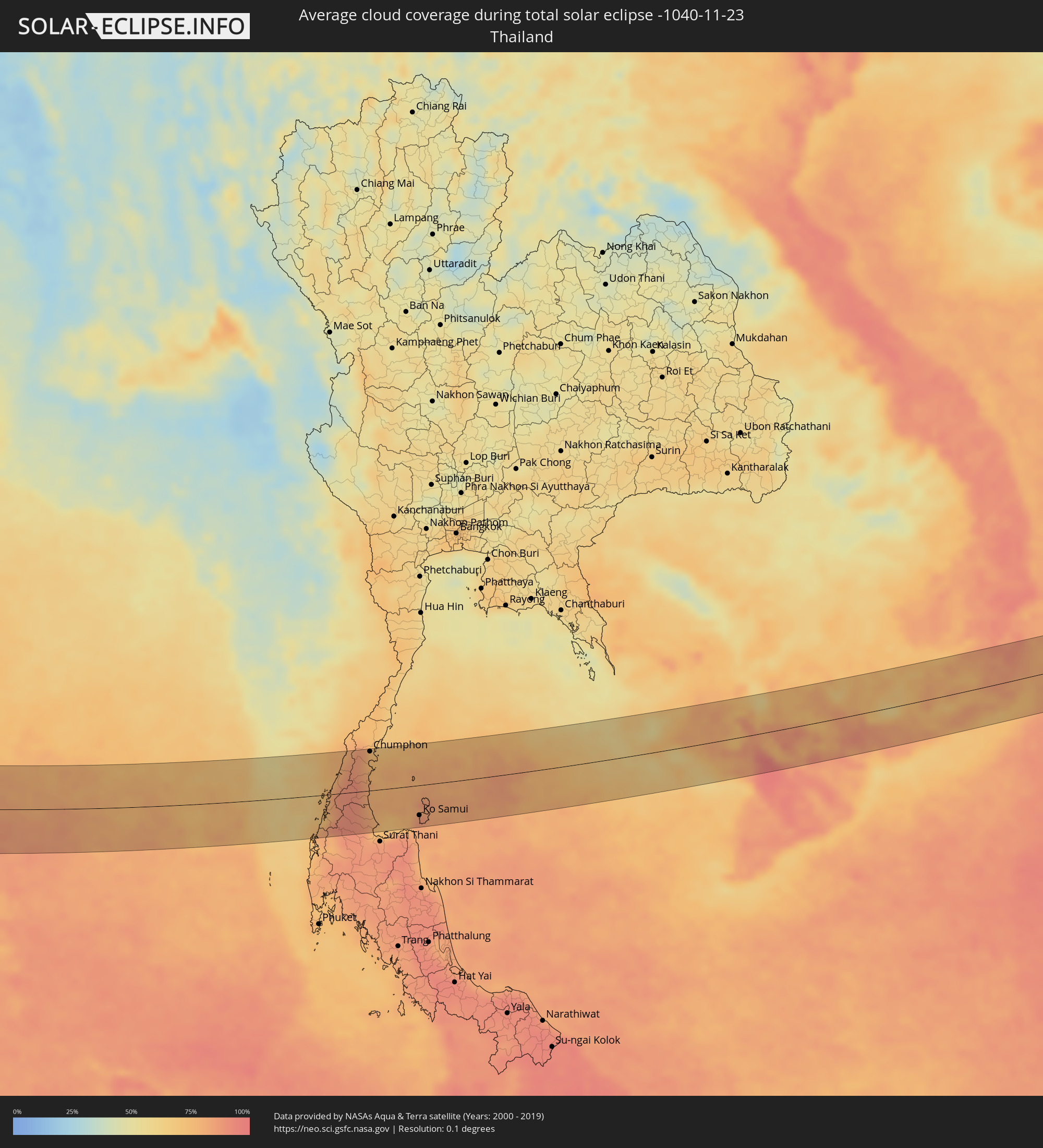 Thailand
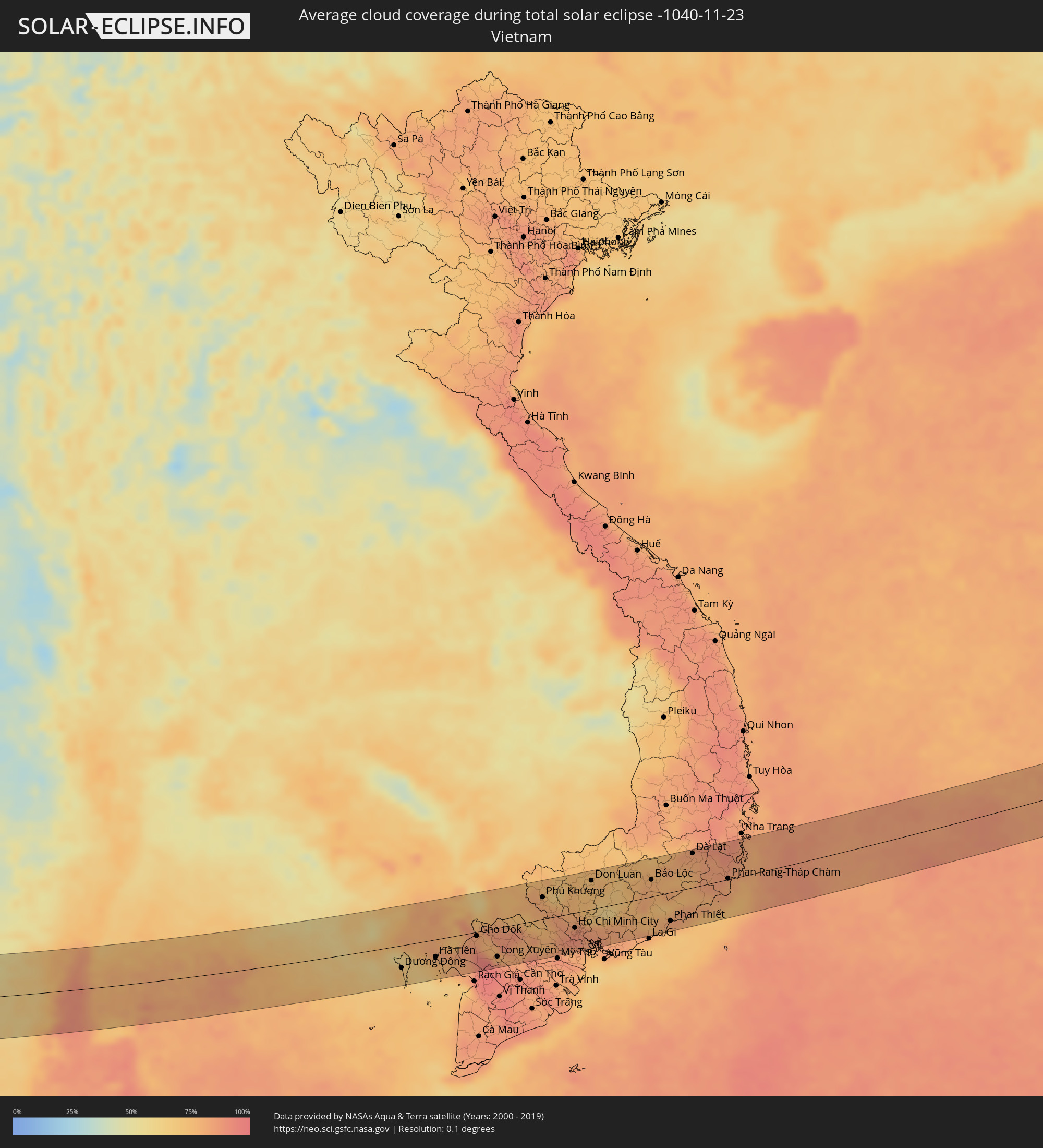 Vietnam
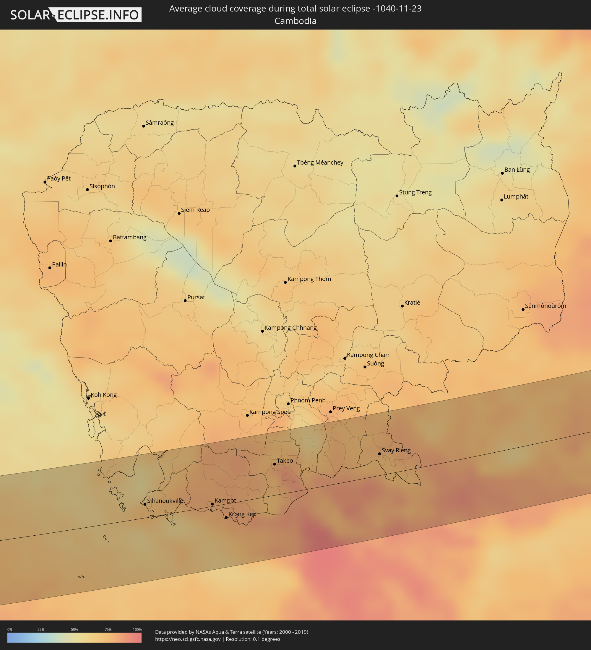 Kambodscha
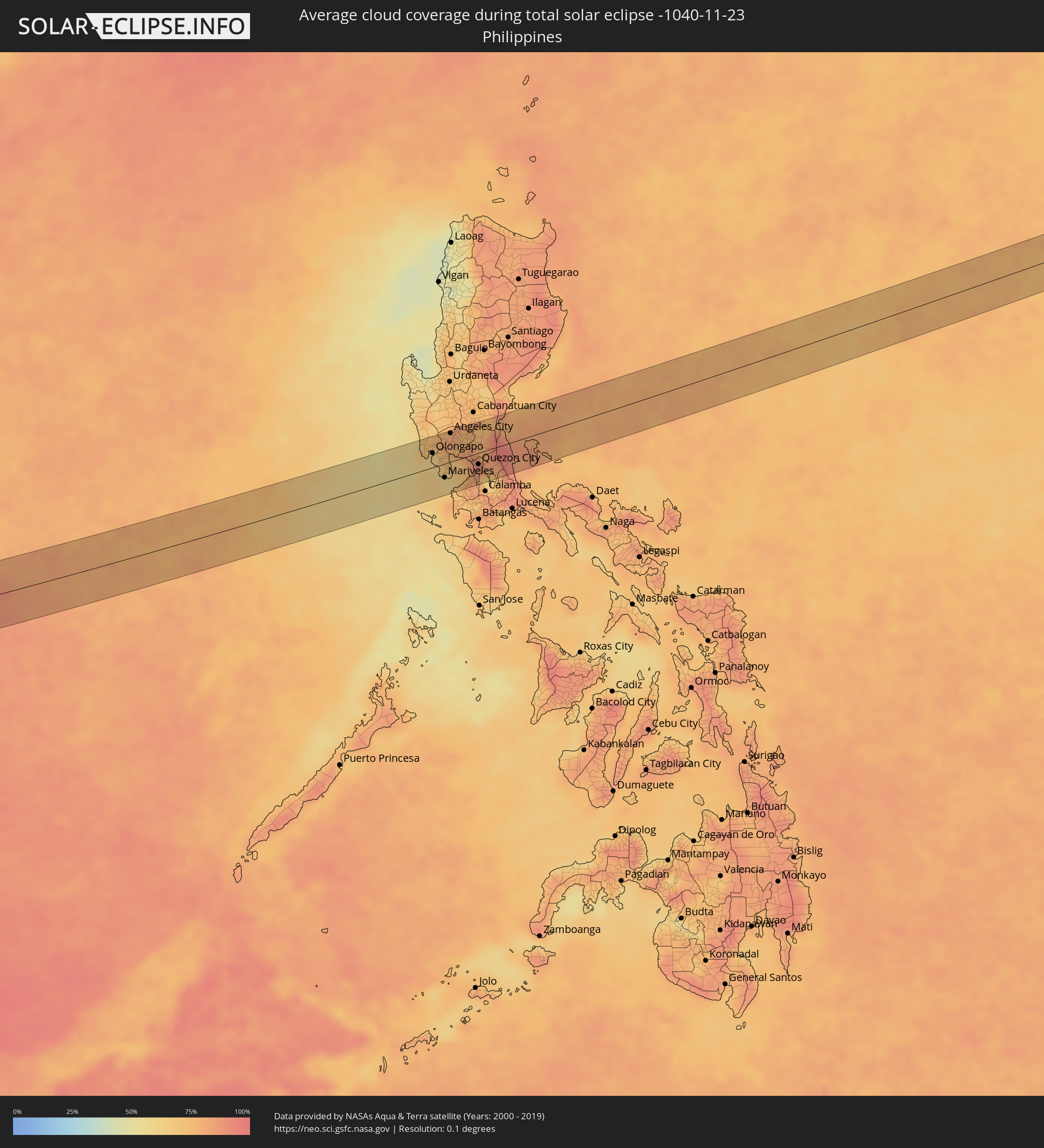 Philippinen
Orte im Finsternispfad
Die nachfolgene Tabelle zeigt Städte und Orte mit mehr als 5.000 Einwohnern, die sich im Finsternispfad befinden. Städte mit mehr als 100.000 Einwohnern sind dick gekennzeichnet. Mit einem Klick auf den Ort öffnet sich eine Detailkarte die die Lage des jeweiligen Ortes zusammen mit dem Verlauf der zentralen Finsternis präsentiert.
| Ort | Typ | Dauer der Verfinsterung | Ortszeit bei maximaler Verfinsterung | Entfernung zur Zentrallinie | Ø Bewölkung |
|
Anávyssos, Attica
|
total | - | 06:52:40 UTC+01:34 | 40 km | 62% |
|
Lávrio, Attica
|
total | - | 06:52:41 UTC+01:34 | 42 km | 61% |
|
Páros, South Aegean
|
total | - | 06:52:33 UTC+01:34 | 18 km | 68% |
|
Náxos, South Aegean
|
total | - | 06:52:38 UTC+01:34 | 28 km | 64% |
|
Archángelos, South Aegean
|
total | - | 06:52:58 UTC+01:34 | 41 km | 56% |
|
El Fureidīs, Haifa
|
total | - | 07:40:04 UTC+02:20 | 48 km | 60% |
|
Haifa, Haifa
|
total | - | 07:40:12 UTC+02:20 | 25 km | 56% |
|
Nahariya, Northern District
|
total | - | 07:40:22 UTC+02:20 | 1 km | 55% |
|
Rekhasim, Haifa
|
total | - | 07:40:14 UTC+02:20 | 27 km | 58% |
|
En Nâqoûra, South Governorate
|
total | - | 07:19:46 UTC+02:00 | 12 km | 55% |
|
Umm el Faḥm, Haifa
|
total | - | 07:40:10 UTC+02:20 | 48 km | 64% |
|
Kafir Yasif, Northern District
|
total | - | 07:40:22 UTC+02:20 | 4 km | 60% |
|
Tyre, South Governorate
|
total | - | 07:19:53 UTC+02:00 | 29 km | 54% |
|
Sīlat al Ḩārithīyah, West Bank
|
total | - | 07:19:32 UTC+02:00 | 45 km | 64% |
|
Al Yāmūn, West Bank
|
total | - | 07:19:31 UTC+02:00 | 48 km | 64% |
|
Janīn, West Bank
|
total | - | 07:19:33 UTC+02:00 | 47 km | 60% |
|
Nazareth, Northern District
|
total | - | 07:40:20 UTC+02:20 | 23 km | 56% |
|
Karmi’el, Northern District
|
total | - | 07:40:27 UTC+02:20 | 1 km | 59% |
|
Dayr Abū Ḑa‘īf, West Bank
|
total | - | 07:19:35 UTC+02:00 | 45 km | 59% |
|
Deir Ḥannā, Northern District
|
total | - | 07:40:27 UTC+02:20 | 4 km | 58% |
|
Safed, Northern District
|
total | - | 07:40:35 UTC+02:20 | 11 km | 60% |
|
Bet She’an, Northern District
|
total | - | 07:40:22 UTC+02:20 | 35 km | 62% |
|
Tiberias, Northern District
|
total | - | 07:40:31 UTC+02:20 | 4 km | 50% |
|
Qiryat Shemona, Northern District
|
total | - | 07:40:45 UTC+02:20 | 39 km | 54% |
|
Waqqāş, Irbid
|
total | - | 07:43:31 UTC+02:23 | 26 km | 62% |
|
Ḩalāwah, Ajlun
|
total | - | 07:43:29 UTC+02:23 | 39 km | 58% |
|
Şammā, Irbid
|
total | - | 07:43:35 UTC+02:23 | 20 km | 59% |
|
‘Ajlūn, Ajlun
|
total | - | 07:43:31 UTC+02:23 | 41 km | 61% |
|
Saḩam al Kaffārāt, Irbid
|
total | - | 07:43:42 UTC+02:23 | 3 km | 58% |
|
Ḩātim, Irbid
|
total | - | 07:43:40 UTC+02:23 | 9 km | 59% |
|
Al Qunayţirah, Quneitra
|
total | - | 07:45:24 UTC+02:25 | 41 km | 55% |
|
Raymūn, Jerash
|
total | - | 07:43:32 UTC+02:23 | 43 km | 61% |
|
Al Kittah, Jerash
|
total | - | 07:43:33 UTC+02:23 | 42 km | 61% |
|
Irbid, Irbid
|
total | - | 07:43:41 UTC+02:23 | 14 km | 58% |
|
Kharjā, Irbid
|
total | - | 07:43:45 UTC+02:23 | 3 km | 57% |
|
Aţ Ţurrah, Irbid
|
total | - | 07:43:48 UTC+02:23 | 0 km | 58% |
|
Jāsim, Daraa
|
total | - | 07:45:29 UTC+02:25 | 38 km | 58% |
|
Ţafas, Daraa
|
total | - | 07:45:22 UTC+02:25 | 13 km | 56% |
|
Dar‘ā, Daraa
|
total | - | 07:45:20 UTC+02:25 | 3 km | 58% |
|
Inkhil, Daraa
|
total | - | 07:45:33 UTC+02:25 | 43 km | 58% |
|
Ash Shaykh Miskīn, Daraa
|
total | - | 07:45:28 UTC+02:25 | 26 km | 54% |
|
Mafraq, Mafraq
|
total | - | 07:43:49 UTC+02:23 | 20 km | 57% |
|
Izra‘, Daraa
|
total | - | 07:45:33 UTC+02:25 | 34 km | 57% |
|
Al Ḩarāk, Daraa
|
total | - | 07:45:32 UTC+02:25 | 24 km | 55% |
|
As Suwaydā’, As-Suwayda
|
total | - | 07:45:41 UTC+02:25 | 31 km | 58% |
|
Şalākhid, As-Suwayda
|
total | - | 07:45:46 UTC+02:25 | 48 km | 56% |
|
Shahbā, As-Suwayda
|
total | - | 07:45:48 UTC+02:25 | 48 km | 56% |
|
Al Azraq ash Shamālī, Zarqa
|
total | - | 07:44:01 UTC+02:23 | 40 km | 42% |
|
Turaif, Northern Borders
|
total | - | 08:28:22 UTC+03:06 | 19 km | 35% |
|
Al Qayşūmah, Eastern Province
|
total | - | 08:34:02 UTC+03:06 | 30 km | 50% |
|
Abqaiq, Eastern Province
|
total | - | 08:37:50 UTC+03:06 | 30 km | 41% |
|
Umm as Sāhik, Eastern Province
|
total | - | 08:38:12 UTC+03:06 | 51 km | 48% |
|
Al Awjām, Eastern Province
|
total | - | 08:38:14 UTC+03:06 | 44 km | 47% |
|
Şafwá, Eastern Province
|
total | - | 08:38:15 UTC+03:06 | 53 km | 54% |
|
At Tūbī, Eastern Province
|
total | - | 08:38:17 UTC+03:06 | 46 km | 54% |
|
Al Qaţīf, Eastern Province
|
total | - | 08:38:20 UTC+03:06 | 44 km | 50% |
|
Tārūt, Eastern Province
|
total | - | 08:38:21 UTC+03:06 | 49 km | 54% |
|
Sayhāt, Eastern Province
|
total | - | 08:38:21 UTC+03:06 | 41 km | 50% |
|
Dammam, Eastern Province
|
total | - | 08:38:25 UTC+03:06 | 39 km | 44% |
|
Dhahran, Eastern Province
|
total | - | 08:38:25 UTC+03:06 | 25 km | 43% |
|
Khobar, Eastern Province
|
total | - | 08:38:32 UTC+03:06 | 29 km | 41% |
|
Dār Kulayb, Southern Governorate
|
total | - | 08:58:10 UTC+03:26 | 23 km | 43% |
|
Madīnat Ḩamad, Central Governorate
|
total | - | 08:58:11 UTC+03:26 | 28 km | 43% |
|
Jidd Ḩafş, Manama
|
total | - | 08:58:15 UTC+03:26 | 40 km | 51% |
|
Madīnat ‘Īsá, Southern Governorate
|
total | - | 08:58:14 UTC+03:26 | 36 km | 51% |
|
Ar Rifā‘, Southern Governorate
|
total | - | 08:58:15 UTC+03:26 | 32 km | 41% |
|
Manama, Manama
|
total | - | 08:58:18 UTC+03:26 | 43 km | 46% |
|
Al Muharraq, Muharraq
|
total | - | 08:58:20 UTC+03:26 | 47 km | 53% |
|
Sitrah, Manama
|
total | - | 08:58:20 UTC+03:26 | 37 km | 46% |
|
Al Ḩadd, Muharraq
|
total | - | 08:58:23 UTC+03:26 | 48 km | 41% |
|
Dukhān, Baladīyat ar Rayyān
|
total | - | 08:58:30 UTC+03:26 | 25 km | 34% |
|
Ash Shayḩānīyah, Baladīyat ar Rayyān
|
total | - | 08:59:05 UTC+03:26 | 9 km | 29% |
|
Umm Şalāl ‘Alī, Baladīyat Umm Şalāl
|
total | - | 08:59:20 UTC+03:26 | 9 km | 30% |
|
Umm Şalāl Muḩammad, Baladīyat Umm Şalāl
|
total | - | 08:59:20 UTC+03:26 | 5 km | 29% |
|
Ar Rayyān, Baladīyat ar Rayyān
|
total | - | 08:59:22 UTC+03:26 | 6 km | 28% |
|
Az̧ Z̧a‘āyin, Baladīyat az̧ Z̧a‘āyin
|
total | - | 08:59:27 UTC+03:26 | 24 km | 33% |
|
Al Khawr, Al Khawr
|
total | - | 08:59:29 UTC+03:26 | 36 km | 34% |
|
Doha, Baladīyat ad Dawḩah
|
total | - | 08:59:29 UTC+03:26 | 3 km | 31% |
|
Al Wukayr, Al Wakrah
|
total | - | 08:59:30 UTC+03:26 | 14 km | 26% |
|
Musay‘īd, Al Wakrah
|
total | - | 08:59:31 UTC+03:26 | 29 km | 28% |
|
Al Wakrah, Al Wakrah
|
total | - | 08:59:36 UTC+03:26 | 9 km | 28% |
|
Ar Ruways, Abu Dhabi
|
total | - | 09:16:15 UTC+03:41 | 56 km | 20% |
|
‘Ibrī, Az̧ Z̧āhirah
|
total | - | 09:22:11 UTC+03:41 | 51 km | 4% |
|
Ādam, Muḩāfaz̧at ad Dākhilīyah
|
total | - | 09:24:02 UTC+03:41 | 20 km | 4% |
|
Udipi, Karnataka
|
total | - | 11:47:59 UTC+05:21 | 25 km | 46% |
|
Mangalore, Karnataka
|
total | - | 11:48:36 UTC+05:21 | 64 km | 52% |
|
Shimoga, Karnataka
|
total | - | 11:49:53 UTC+05:21 | 70 km | 48% |
|
Bhadrāvati, Karnataka
|
total | - | 11:50:20 UTC+05:21 | 67 km | 50% |
|
Mysore, Karnataka
|
total | - | 11:54:12 UTC+05:21 | 56 km | 65% |
|
Mandya, Karnataka
|
total | - | 11:54:47 UTC+05:21 | 23 km | 65% |
|
Tumkūr, Karnataka
|
total | - | 11:54:46 UTC+05:21 | 70 km | 57% |
|
Bengaluru, Karnataka
|
total | - | 11:56:29 UTC+05:21 | 51 km | 59% |
|
Salem, Tamil Nadu
|
total | - | 11:59:11 UTC+05:21 | 67 km | 76% |
|
Robertsonpet, Karnataka
|
total | - | 11:58:31 UTC+05:21 | 74 km | 65% |
|
Tiruvannāmalai, Tamil Nadu
|
total | - | 12:01:28 UTC+05:21 | 26 km | 75% |
|
Cuddalore, Tamil Nadu
|
total | - | 12:03:54 UTC+05:21 | 2 km | 77% |
|
Puducherry, Pondicherry
|
total | - | 12:03:57 UTC+05:21 | 21 km | 75% |
|
Ranong, Ranong
|
total | - | 14:19:35 UTC+06:42 | 12 km | 78% |
|
Ban Nam Yuen, Chumphon
|
total | - | 14:20:11 UTC+06:42 | 0 km | 89% |
|
Lang Suan, Chumphon
|
total | - | 14:20:38 UTC+06:42 | 5 km | 83% |
|
Chumphon, Chumphon
|
total | - | 14:20:32 UTC+06:42 | 65 km | 75% |
|
Chaiya, Surat Thani
|
total | - | 14:21:15 UTC+06:42 | 58 km | 80% |
|
Ko Samui, Surat Thani
|
total | - | 14:22:51 UTC+06:42 | 50 km | 86% |
|
Ko Pha Ngan, Nakhon Si Thammarat
|
total | - | 14:22:55 UTC+06:42 | 27 km | 87% |
|
Sihanoukville, Preah Sihanouk
|
total | - | 14:29:55 UTC+06:42 | 14 km | 71% |
|
Kampot, Kampot
|
total | - | 14:31:13 UTC+06:42 | 2 km | 76% |
|
Krong Kep, Kep
|
total | - | 14:31:33 UTC+06:42 | 15 km | 74% |
|
Phumĭ Véal Srê, Takeo
|
total | - | 14:32:10 UTC+06:42 | 31 km | 75% |
|
Takeo, Takeo
|
total | - | 14:32:10 UTC+06:42 | 32 km | 75% |
|
Cho Dok, An Giang
|
total | - | 14:57:34 UTC+07:06 | 6 km | 87% |
|
Long Xuyên, An Giang
|
total | - | 14:58:21 UTC+07:06 | 47 km | 93% |
|
Svay Rieng, Svay Rieng
|
total | - | 14:34:02 UTC+06:42 | 22 km | 75% |
|
Tân An, Long An
|
total | - | 15:00:04 UTC+07:06 | 51 km | 89% |
|
Củ Chi, Ho Chi Minh City
|
total | - | 14:59:58 UTC+07:06 | 5 km | 85% |
|
Ho Chi Minh City, Ho Chi Minh City
|
total | - | 15:00:17 UTC+07:06 | 25 km | 91% |
|
Thủ Dầu Một, Bình Dương
|
total | - | 15:00:15 UTC+07:06 | 8 km | 86% |
|
Cần Giuộc, Long An
|
total | - | 15:00:29 UTC+07:06 | 49 km | 84% |
|
Biên Hòa, Đồng Nai
|
total | - | 15:00:34 UTC+07:06 | 16 km | 86% |
|
Bảo Lộc, Lâm Đồng
|
total | - | 15:01:57 UTC+07:06 | 28 km | 79% |
|
Phan Thiết, Bình Thuận
|
total | - | 15:02:48 UTC+07:06 | 47 km | 72% |
|
Ðà Lạt, Lâm Đồng
|
total | - | 15:02:48 UTC+07:06 | 56 km | 79% |
|
Phan Rang-Tháp Chàm, Ninh Thuận
|
total | - | 15:03:55 UTC+07:06 | 1 km | 80% |
|
Cam Ranh, Khánh Hòa
|
total | - | 15:04:00 UTC+07:06 | 36 km | 83% |
|
Olongapo, Central Luzon
|
total | - | 16:09:47 UTC+08:00 | 25 km | 59% |
|
Mariveles, Central Luzon
|
total | - | 16:10:13 UTC+08:00 | 24 km | 60% |
|
Angeles City, Central Luzon
|
total | - | 16:09:52 UTC+08:00 | 49 km | 81% |
|
San Fernando, Central Luzon
|
total | - | 16:10:03 UTC+08:00 | 33 km | 75% |
|
Arayat, Central Luzon
|
total | - | 16:10:03 UTC+08:00 | 43 km | 74% |
|
Malolos, Central Luzon
|
total | - | 16:10:16 UTC+08:00 | 9 km | 79% |
|
Baliuag, Central Luzon
|
total | - | 16:10:17 UTC+08:00 | 18 km | 82% |
|
Cavite City, Calabarzon
|
total | - | 16:10:34 UTC+08:00 | 32 km | 82% |
|
Dasmariñas, Calabarzon
|
total | - | 16:10:41 UTC+08:00 | 50 km | 82% |
|
San Jose del Monte, Central Luzon
|
total | - | 16:10:30 UTC+08:00 | 2 km | 86% |
|
Quezon City, Metro Manila
|
total | - | 16:10:36 UTC+08:00 | 19 km | 81% |
|
Binangonan, Calabarzon
|
total | - | 16:10:50 UTC+08:00 | 44 km | 65% |
|
Rodriguez, Calabarzon
|
total | - | 16:10:40 UTC+08:00 | 12 km | 82% |