Totale Sonnenfinsternis vom 08.04.0042
| Wochentag: | Dienstag |
| Maximale Dauer der Verfinsterung: | 05m05s |
| Maximale Breite des Finsternispfades: | 229 km |
| Saroszyklus: | 78 |
| Bedeckungsgrad: | 100% |
| Magnitude: | 1.0588 |
| Gamma: | -0.5449 |
Wo kann man die Sonnenfinsternis vom 08.04.0042 sehen?
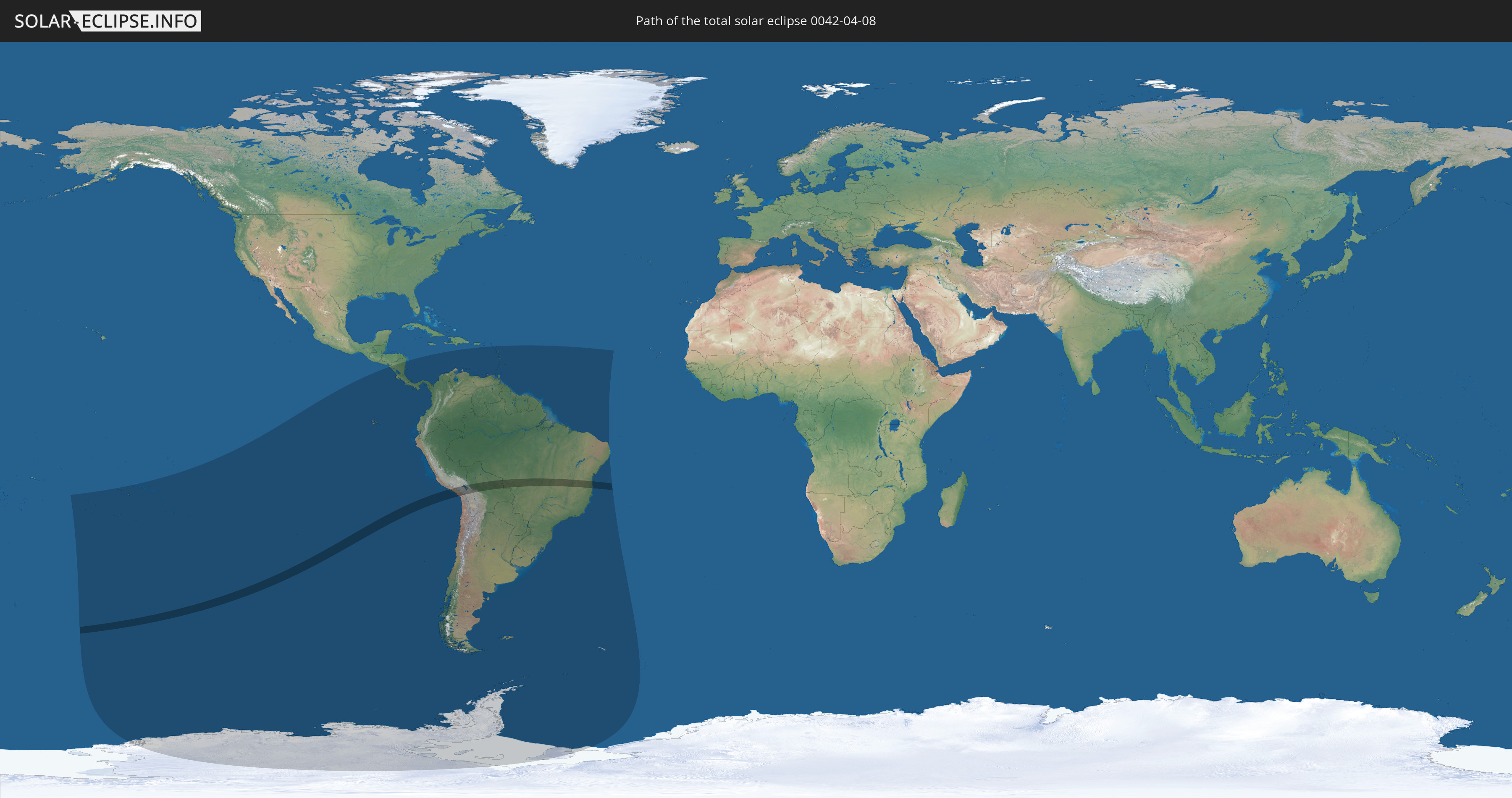
Die Sonnenfinsternis am 08.04.0042 kann man in 35 Ländern als partielle Sonnenfinsternis beobachten.
Der Finsternispfad verläuft durch 4 Länder. Nur in diesen Ländern ist sie als totale Sonnenfinsternis zu sehen.
In den folgenden Ländern ist die Sonnenfinsternis total zu sehen
 Chile
Chile
 Peru
Peru
 Brasilien
 Bolivien
In den folgenden Ländern ist die Sonnenfinsternis partiell zu sehen
 Antarktika
 Kiribati
 Cookinseln
 Französisch-Polynesien
 Pitcairninseln
 Chile
Chile
 Ecuador
 Nicaragua
 Costa Rica
 Panama
 Kolumbien
 Peru
Peru
 Brasilien
 Argentinien
 Venezuela
 Aruba
Aruba
 Bolivien
 St. Kitts und Nevis
 Paraguay
 Antigua und Barbuda
 Montserrat
 Trinidad und Tobago
 Guadeloupe
 Grenada
 Dominica
 St. Vincent und die Grenadinen
 Falklandinseln
 Guyana
 Martinique
 St. Lucia
 Barbados
 Uruguay
 Suriname
 Französisch-Guayana
 Südgeorgien und die Südlichen Sandwichinseln
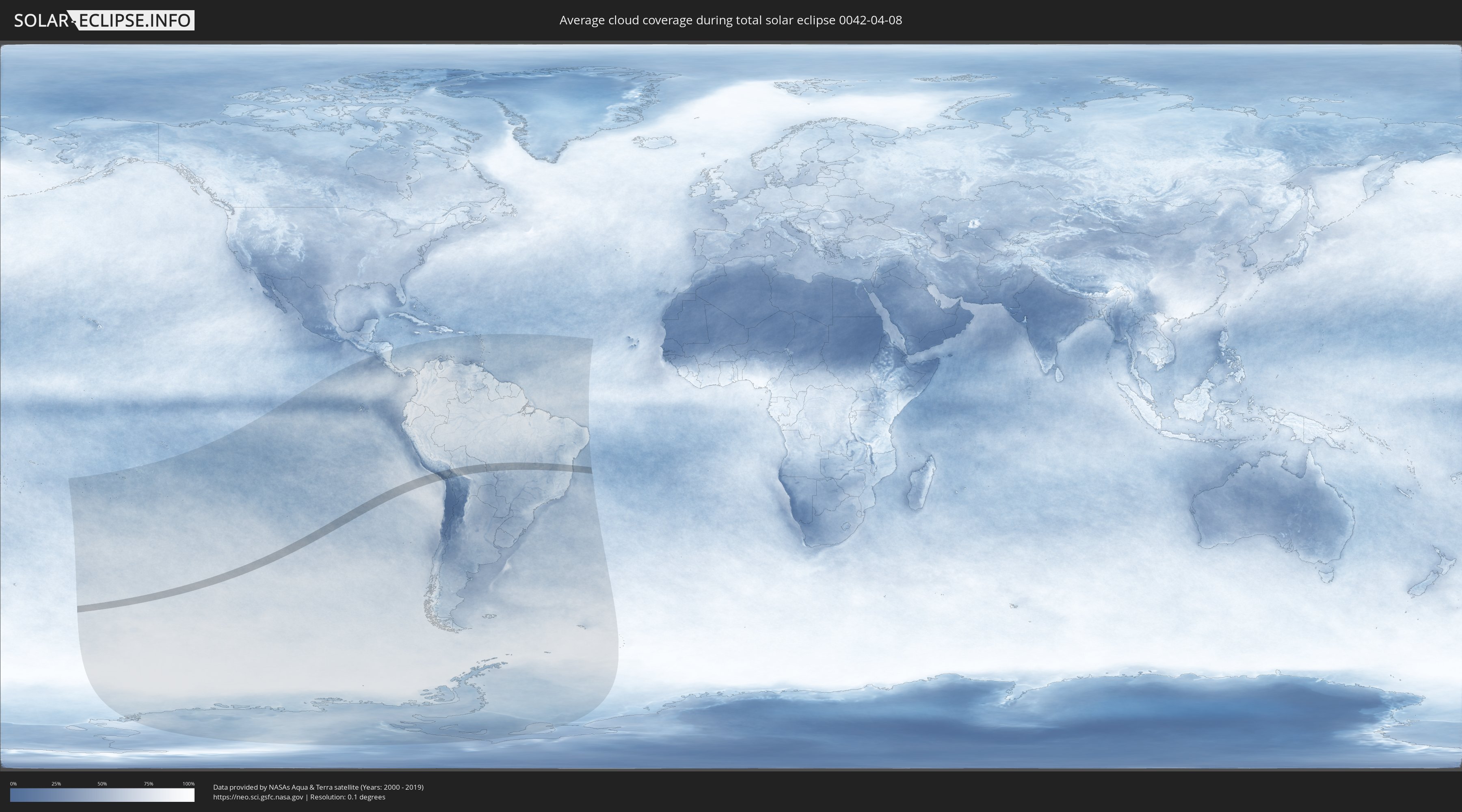
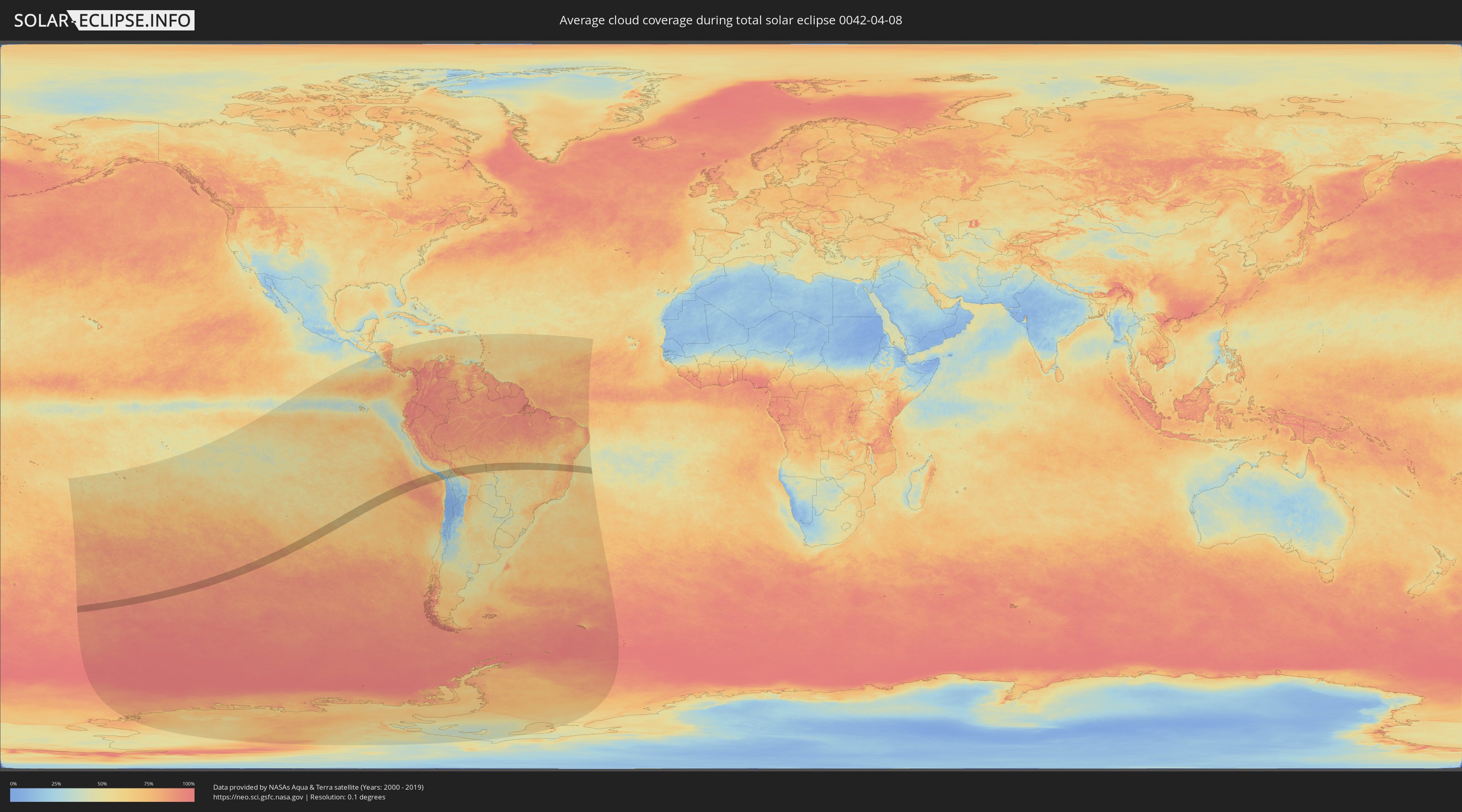
Wie wird das Wetter während der totalen Sonnenfinsternis am 08.04.0042?
Wo ist der beste Ort, um die totale Sonnenfinsternis vom 08.04.0042 zu beobachten?
Die folgenden Karten zeigen die durchschnittliche Bewölkung für den Tag, an dem die totale Sonnenfinsternis
stattfindet. Mit Hilfe der Karten lässt sich der Ort entlang des Finsternispfades eingrenzen,
der die besten Aussichen auf einen klaren wolkenfreien Himmel bietet.
Trotzdem muss man immer lokale Gegenenheiten beachten und sollte sich genau über das Wetter an seinem
gewählten Beobachtungsort informieren.
Die Daten stammen von den beiden NASA-Satelliten
AQUA und TERRA
und wurden über einen Zeitraum von 19 Jahren (2000 - 2019) gemittelt.
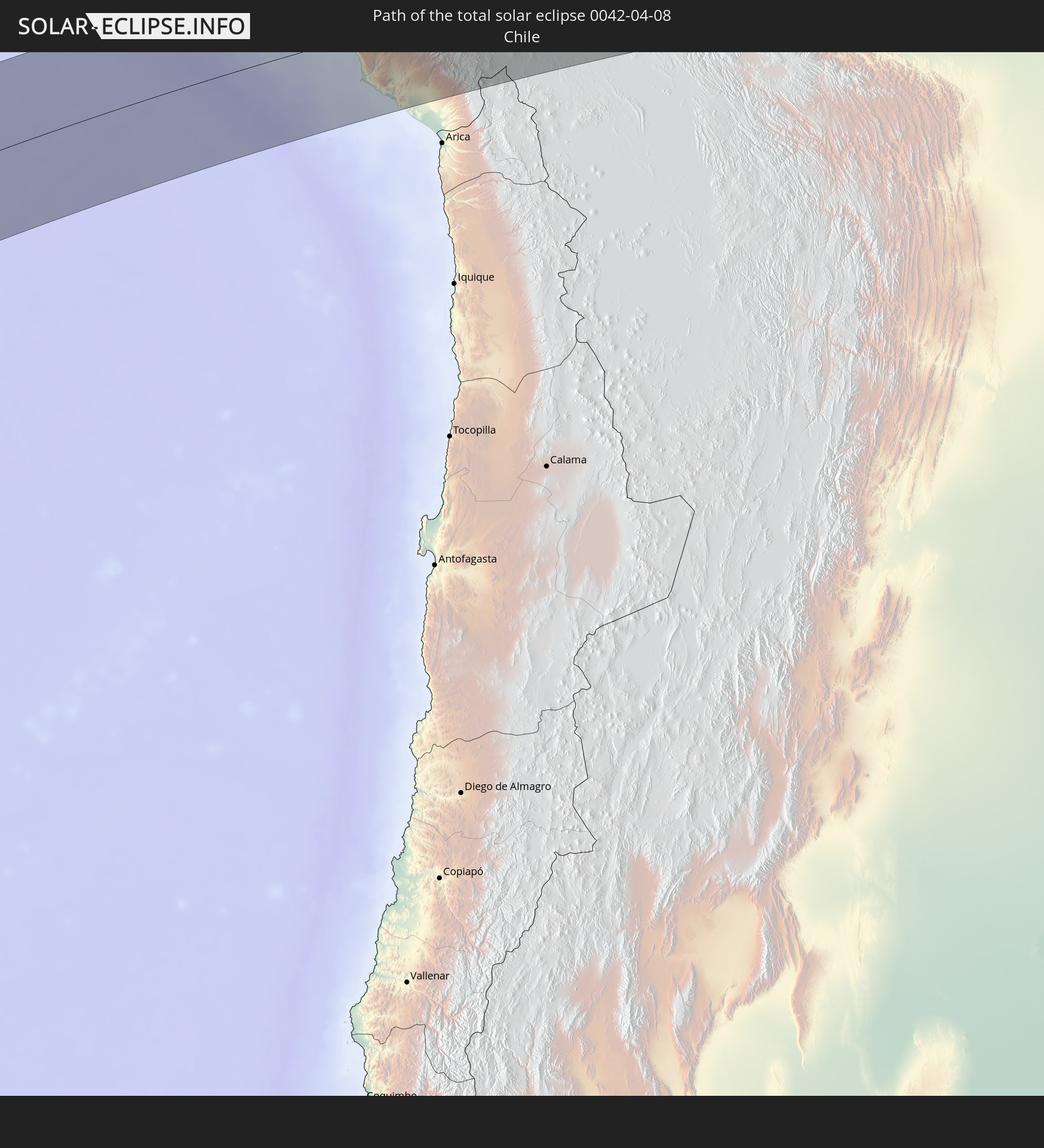
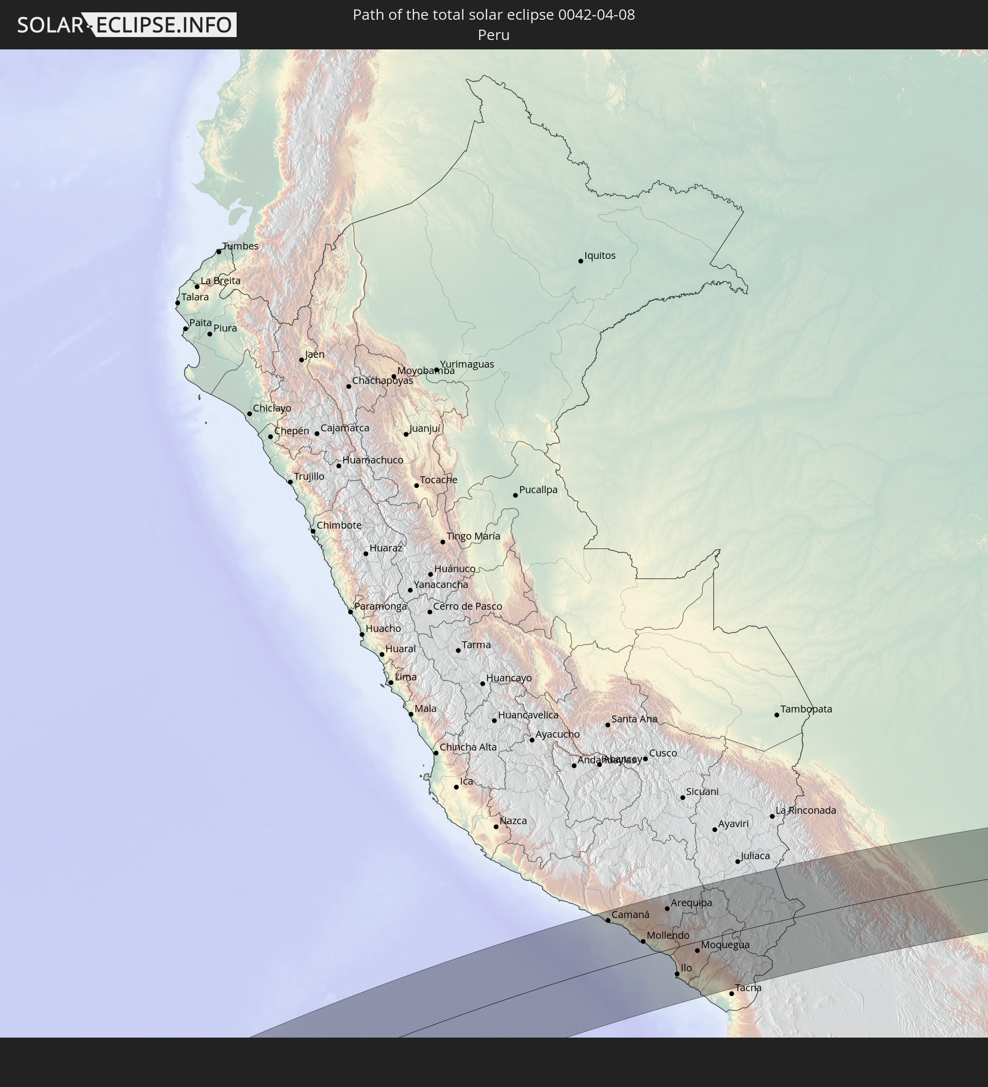
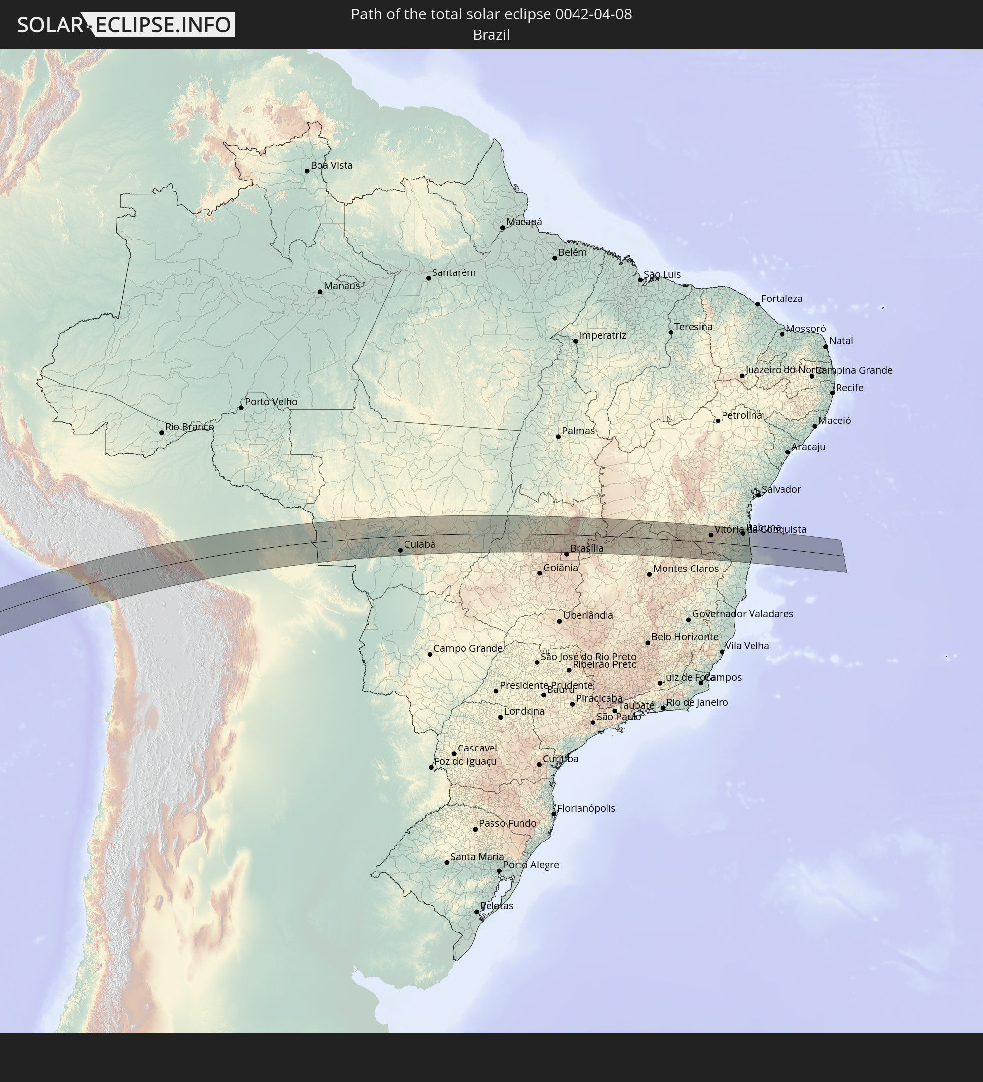
Detaillierte Länderkarten
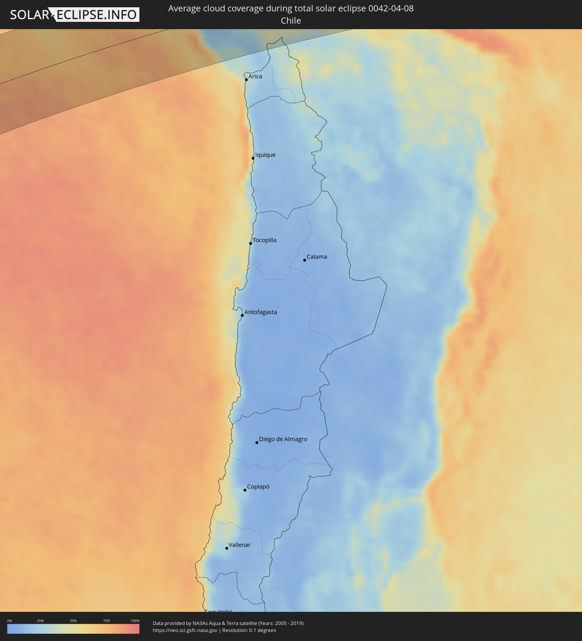 Chile
Chile
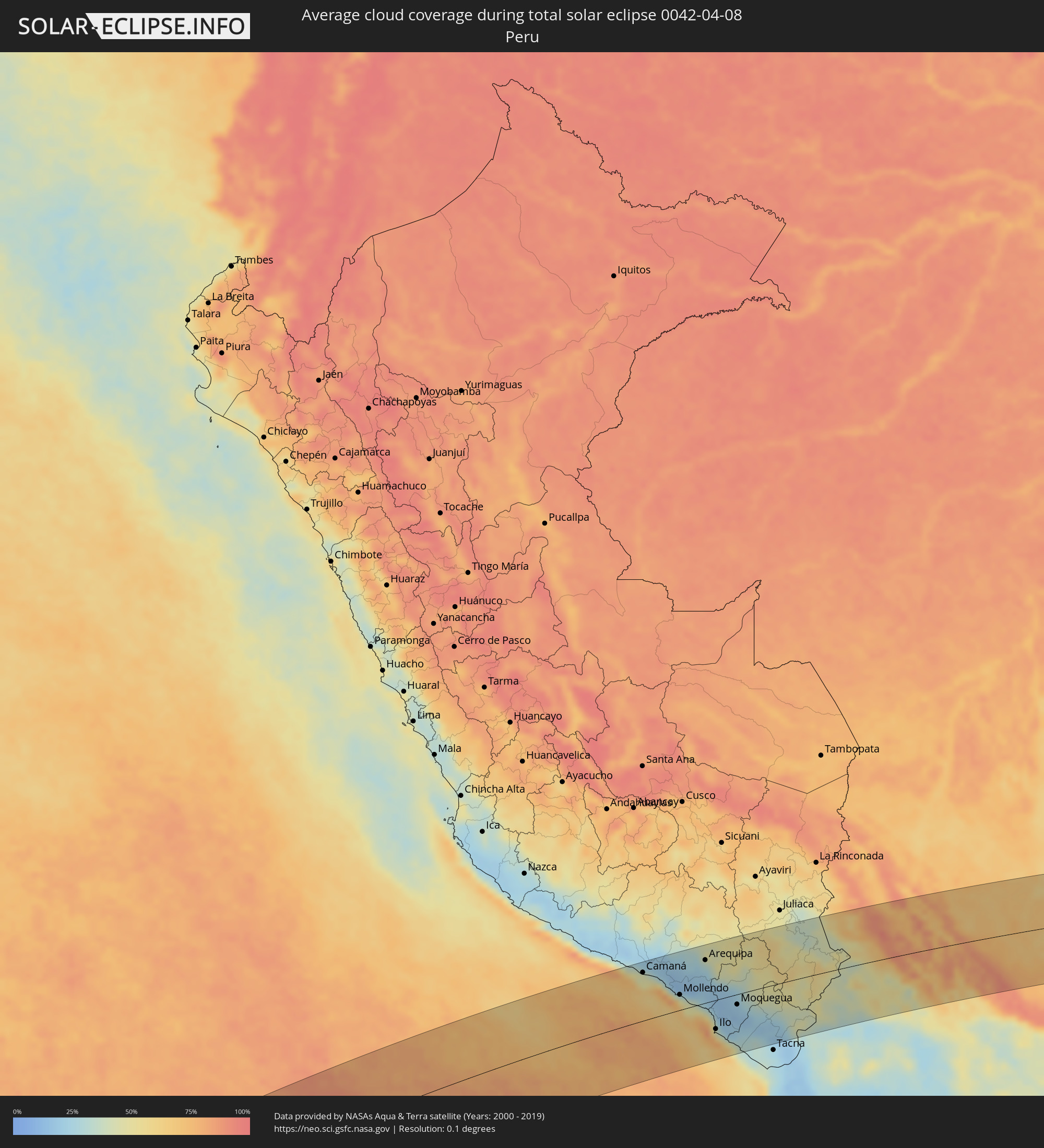 Peru
Peru
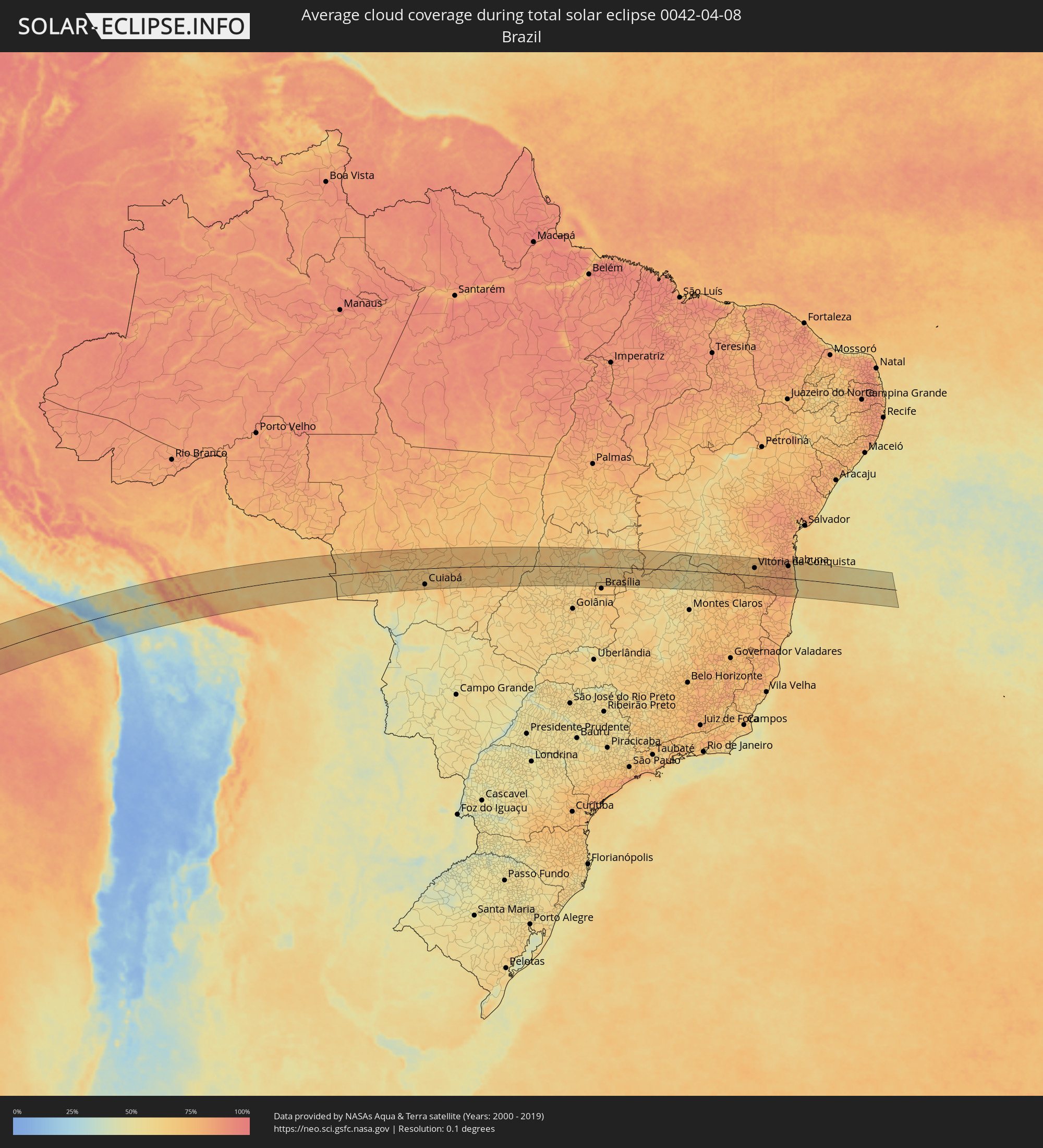 Brasilien
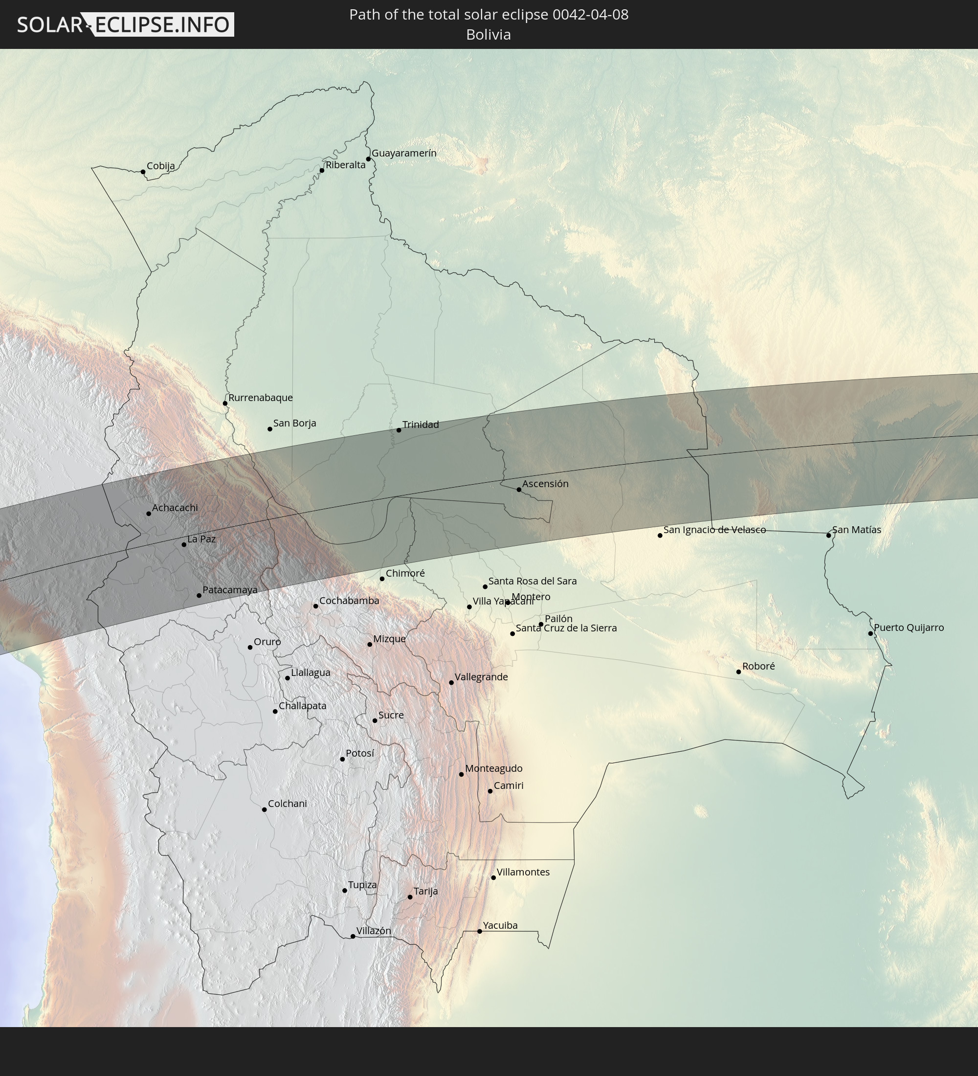
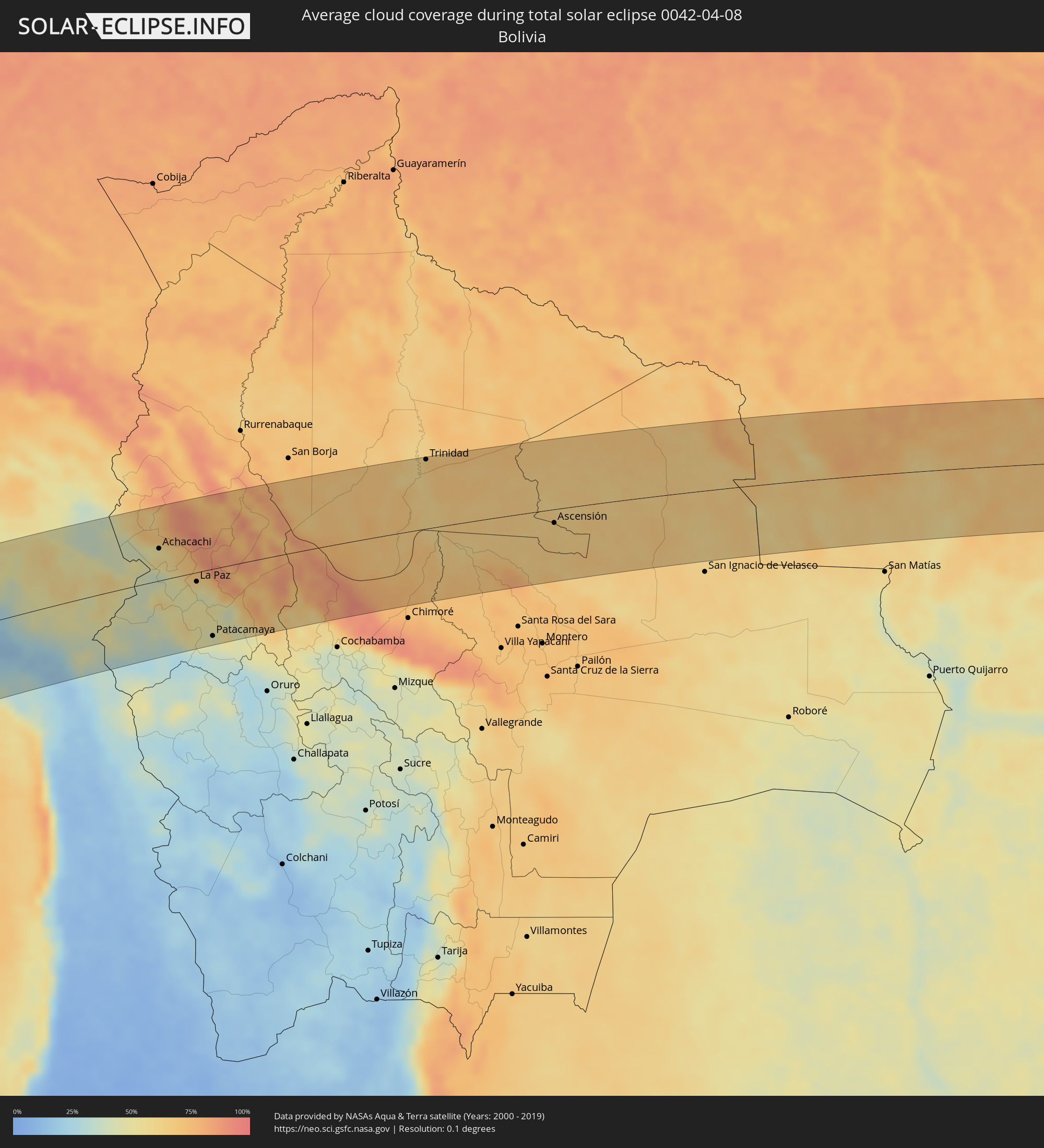 Bolivien
Orte im Finsternispfad
Die nachfolgene Tabelle zeigt Städte und Orte mit mehr als 5.000 Einwohnern, die sich im Finsternispfad befinden. Städte mit mehr als 100.000 Einwohnern sind dick gekennzeichnet. Mit einem Klick auf den Ort öffnet sich eine Detailkarte die die Lage des jeweiligen Ortes zusammen mit dem Verlauf der zentralen Finsternis präsentiert.
| Ort | Typ | Dauer der Verfinsterung | Ortszeit bei maximaler Verfinsterung | Entfernung zur Zentrallinie | Ø Bewölkung |
|
Camaná, Arequipa
|
total | - | 14:26:17 UTC-05:08 | 93 km | 46% |
|
Mollendo, Arequipa
|
total | - | 14:27:00 UTC-05:08 | 29 km | 48% |
|
Punta de Bombón, Arequipa
|
total | - | 14:27:12 UTC-05:08 | 7 km | 49% |
|
Cocachacra, Arequipa
|
total | - | 14:27:23 UTC-05:08 | 15 km | 46% |
|
Yura, Arequipa
|
total | - | 14:28:42 UTC-05:08 | 103 km | 26% |
|
Arequipa, Arequipa
|
total | - | 14:28:45 UTC-05:08 | 83 km | 29% |
|
Ilo, Moquegua
|
total | - | 14:27:22 UTC-05:08 | 56 km | 39% |
|
Pacocha, Moquegua
|
total | - | 14:27:27 UTC-05:08 | 50 km | 39% |
|
Moquegua, Moquegua
|
total | - | 14:28:42 UTC-05:08 | 20 km | 20% |
|
Torata, Moquegua
|
total | - | 14:29:02 UTC-05:08 | 9 km | 26% |
|
Ilabaya, Tacna
|
total | - | 14:29:08 UTC-05:08 | 55 km | 22% |
|
Puno, Puno
|
total | - | 14:32:11 UTC-05:08 | 102 km | 42% |
|
Ilave, Puno
|
total | - | 14:32:28 UTC-05:08 | 67 km | 49% |
|
Juli, Puno
|
total | - | 14:32:39 UTC-05:08 | 48 km | 49% |
|
Yunguyo, Puno
|
total | - | 14:33:13 UTC-05:08 | 35 km | 52% |
|
Desaguadero, Puno
|
total | - | 15:08:51 UTC-04:32 | 0 km | 41% |
|
San Pedro, La Paz
|
total | - | 15:09:37 UTC-04:32 | 31 km | 45% |
|
Achacachi, La Paz
|
total | - | 15:10:09 UTC-04:32 | 47 km | 57% |
|
La Paz, La Paz
|
total | - | 15:10:25 UTC-04:32 | 14 km | 53% |
|
Patacamaya, La Paz
|
total | - | 15:09:47 UTC-04:32 | 99 km | 44% |
|
Trinidad, El Beni
|
total | - | 15:17:37 UTC-04:32 | 104 km | 68% |
|
Ascensión, Santa Cruz
|
total | - | 15:19:03 UTC-04:32 | 20 km | 64% |
|
Pontes e Lacerda, Mato Grosso
|
total | - | 16:18:29 UTC-03:38 | 13 km | 62% |
|
Nova Olímpia, Mato Grosso
|
total | - | 16:21:15 UTC-03:38 | 18 km | 70% |
|
Barra do Bugres, Mato Grosso
|
total | - | 16:21:02 UTC-03:38 | 14 km | 69% |
|
Arenápolis, Mato Grosso
|
total | - | 16:22:06 UTC-03:38 | 53 km | 67% |
|
Nortelândia, Mato Grosso
|
total | - | 16:22:09 UTC-03:38 | 53 km | 67% |
|
Diamantino, Mato Grosso
|
total | - | 16:22:34 UTC-03:38 | 55 km | 70% |
|
Rosário Oeste, Mato Grosso
|
total | - | 16:22:05 UTC-03:38 | 8 km | 69% |
|
Nobres, Mato Grosso
|
total | - | 16:22:19 UTC-03:38 | 20 km | 67% |
|
Cuiabá, Mato Grosso
|
total | - | 16:21:32 UTC-03:38 | 78 km | 71% |
|
Chapada dos Guimarães, Mato Grosso
|
total | - | 16:22:02 UTC-03:38 | 65 km | 68% |
|
Mozarlândia, Goiás
|
total | - | 16:59:15 UTC-03:06 | 3 km | 67% |
|
Crixás, Goiás
|
total | - | 16:59:54 UTC-03:06 | 26 km | 62% |
|
Itapuranga, Goiás
|
total | - | 16:58:49 UTC-03:06 | 87 km | 59% |
|
Rubiataba, Goiás
|
total | - | 16:59:21 UTC-03:06 | 43 km | 61% |
|
Uruana, Goiás
|
total | - | 16:59:04 UTC-03:06 | 80 km | 60% |
|
Ceres, Goiás
|
total | - | 16:59:20 UTC-03:06 | 58 km | 63% |
|
Rialma, Goiás
|
total | - | 16:59:20 UTC-03:06 | 59 km | 63% |
|
Itapaci, Goiás
|
total | - | 16:59:45 UTC-03:06 | 18 km | 61% |
|
Uruaçu, Goiás
|
total | - | 17:00:29 UTC-03:06 | 30 km | 63% |
|
Goianésia, Goiás
|
total | - | 16:59:39 UTC-03:06 | 58 km | 62% |
|
Barro Alto, Goiás
|
total | - | 17:00:10 UTC-03:06 | 19 km | 64% |
|
Niquelândia, Goiás
|
total | - | 17:00:59 UTC-03:06 | 37 km | 63% |
|
Padre Bernardo, Goiás
|
total | - | 17:00:21 UTC-03:06 | 40 km | 64% |
|
Planaltina, Federal District
|
total | - | 17:00:16 UTC-03:06 | 88 km | 70% |
|
Planaltina, Goiás
|
total | - | 17:00:28 UTC-03:06 | 69 km | 68% |
|
Formosa, Goiás
|
total | - | 17:00:33 UTC-03:06 | 78 km | 71% |
|
Iaciara, Goiás
|
total | - | 17:02:27 UTC-03:06 | 85 km | 63% |
|
Buritis, Minas Gerais
|
total | - | 17:00:59 UTC-03:06 | 83 km | 60% |
|
Posse, Goiás
|
total | - | 17:02:36 UTC-03:06 | 87 km | 66% |
|
Januária, Minas Gerais
|
total | - | 17:02:11 UTC-03:06 | 58 km | 48% |
|
Itacarambi, Minas Gerais
|
total | - | 17:02:42 UTC-03:06 | 13 km | 48% |
|
Manga, Minas Gerais
|
total | - | 17:03:07 UTC-03:06 | 26 km | 55% |
|
Carinhanha, Bahia
|
total | - | 17:36:07 UTC-02:34 | 77 km | 54% |
|
Barreiro do Jaíba, Minas Gerais
|
total | - | 17:02:24 UTC-03:06 | 67 km | 58% |
|
Janaúba, Minas Gerais
|
total | - | 17:02:20 UTC-03:06 | 86 km | 60% |
|
Palmas de Monte Alto, Bahia
|
total | - | 17:36:24 UTC-02:34 | 86 km | 63% |
|
Porteirinha, Minas Gerais
|
total | - | 17:02:31 UTC-03:06 | 77 km | 60% |
|
Monte Azul, Minas Gerais
|
total | - | 17:03:10 UTC-03:06 | 11 km | 62% |
|
Mato Verde, Minas Gerais
|
total | - | 17:02:56 UTC-03:06 | 38 km | 58% |
|
Espinosa, Minas Gerais
|
total | - | 17:03:26 UTC-03:06 | 15 km | 64% |
|
Rio Pardo de Minas, Minas Gerais
|
total | - | 17:02:51 UTC-03:06 | 59 km | 69% |
|
Taiobeiras, Minas Gerais
|
total | - | 17:02:46 UTC-03:06 | 79 km | 69% |
|
Caculé, Bahia
|
total | - | 17:36:33 UTC-02:34 | 66 km | 68% |
|
São João do Paraíso, Minas Gerais
|
total | - | 17:03:21 UTC-03:06 | 22 km | 72% |
|
Santana, Bahia
|
total | - | 17:36:44 UTC-02:34 | 74 km | 73% |
|
Águas Vermelhas, Minas Gerais
|
total | - | 17:03:07 UTC-03:06 | 66 km | 74% |
|
São Felipe, Bahia
|
total | - | 17:36:31 UTC-02:34 | 36 km | 67% |
|
Vitória da Conquista, Bahia
|
total | - | 17:36:41 UTC-02:34 | 37 km | 74% |
|
Itambé, Bahia
|
total | - | 17:36:22 UTC-02:34 | 3 km | 76% |
|
Poções, Bahia
|
total | - | 17:37:09 UTC-02:34 | 79 km | 76% |
|
Itapetinga, Bahia
|
total | - | 17:36:29 UTC-02:34 | 0 km | 80% |
|
Iguaí, Bahia
|
total | - | 17:37:01 UTC-02:34 | 56 km | 79% |
|
Itororó, Bahia
|
total | - | 17:36:40 UTC-02:34 | 16 km | 80% |
|
Itarantim, Bahia
|
total | - | 17:36:08 UTC-02:34 | 44 km | 80% |
|
Ibicuí, Bahia
|
total | - | 17:36:58 UTC-02:34 | 48 km | 81% |
|
Pau Brasil, Bahia
|
total | - | 17:36:27 UTC-02:34 | 18 km | 80% |
|
Ibicaraí, Bahia
|
total | - | 17:37:04 UTC-02:34 | 49 km | 81% |
|
Coaraci, Bahia
|
total | - | 17:37:17 UTC-02:34 | 74 km | 84% |
|
Itajuípe, Bahia
|
total | - | 17:37:18 UTC-02:34 | 72 km | 81% |
|
Mascote, Bahia
|
total | - | 17:36:28 UTC-02:34 | 26 km | 82% |
|
Buerarema, Bahia
|
total | - | 17:37:03 UTC-02:34 | 41 km | 82% |
|
Uruçuca, Bahia
|
total | - | 17:37:24 UTC-02:34 | 82 km | 80% |
|
Itabuna, Bahia
|
total | - | 17:37:13 UTC-02:34 | 61 km | 83% |
|
Una, Bahia
|
total | - | 17:36:47 UTC-02:34 | 6 km | 72% |
|
Ilhéus, Bahia
|
total | - | 17:37:17 UTC-02:34 | 62 km | 56% |
|
Canavieiras, Bahia
|
total | - | 17:36:27 UTC-02:34 | 35 km | 58% |
|
Belmonte, Bahia
|
total | - | 17:36:17 UTC-02:34 | 55 km | 62% |