Total solar eclipse of 12/05/-1562
| Day of week: | Friday |
| Maximum duration of eclipse: | 03m50s |
| Maximum width of eclipse path: | 154 km |
| Saros cycle: | 17 |
| Coverage: | 100% |
| Magnitude: | 1.045 |
| Gamma: | -0.2314 |
Wo kann man die Sonnenfinsternis vom 12/05/-1562 sehen?
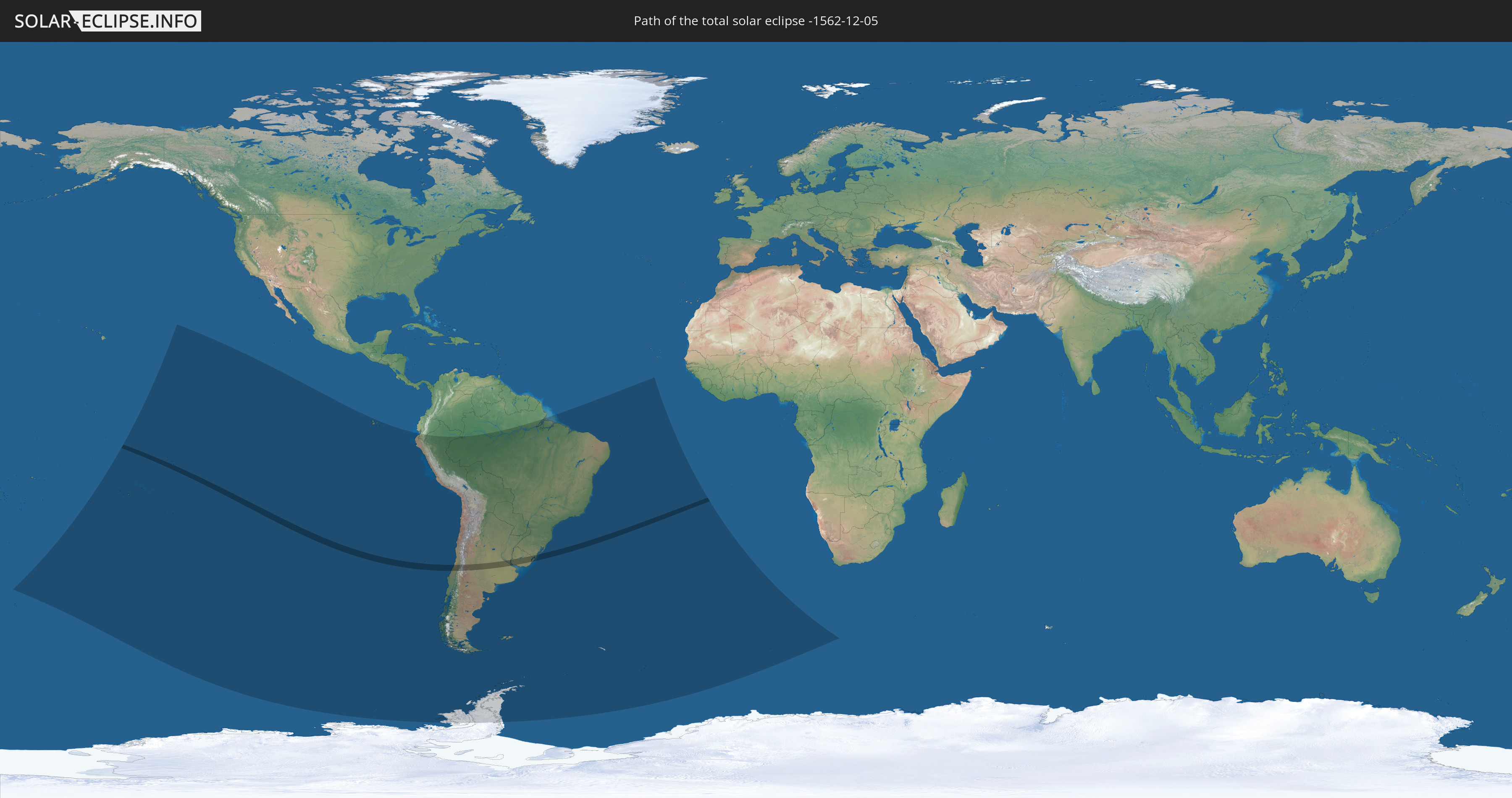
Die Sonnenfinsternis am 12/05/-1562 kann man in 18 Ländern als partielle Sonnenfinsternis beobachten.
Der Finsternispfad verläuft durch 4 Länder. Nur in diesen Ländern ist sie als total Sonnenfinsternis zu sehen.
In den folgenden Ländern ist die Sonnenfinsternis total zu sehen
 Chile
Chile
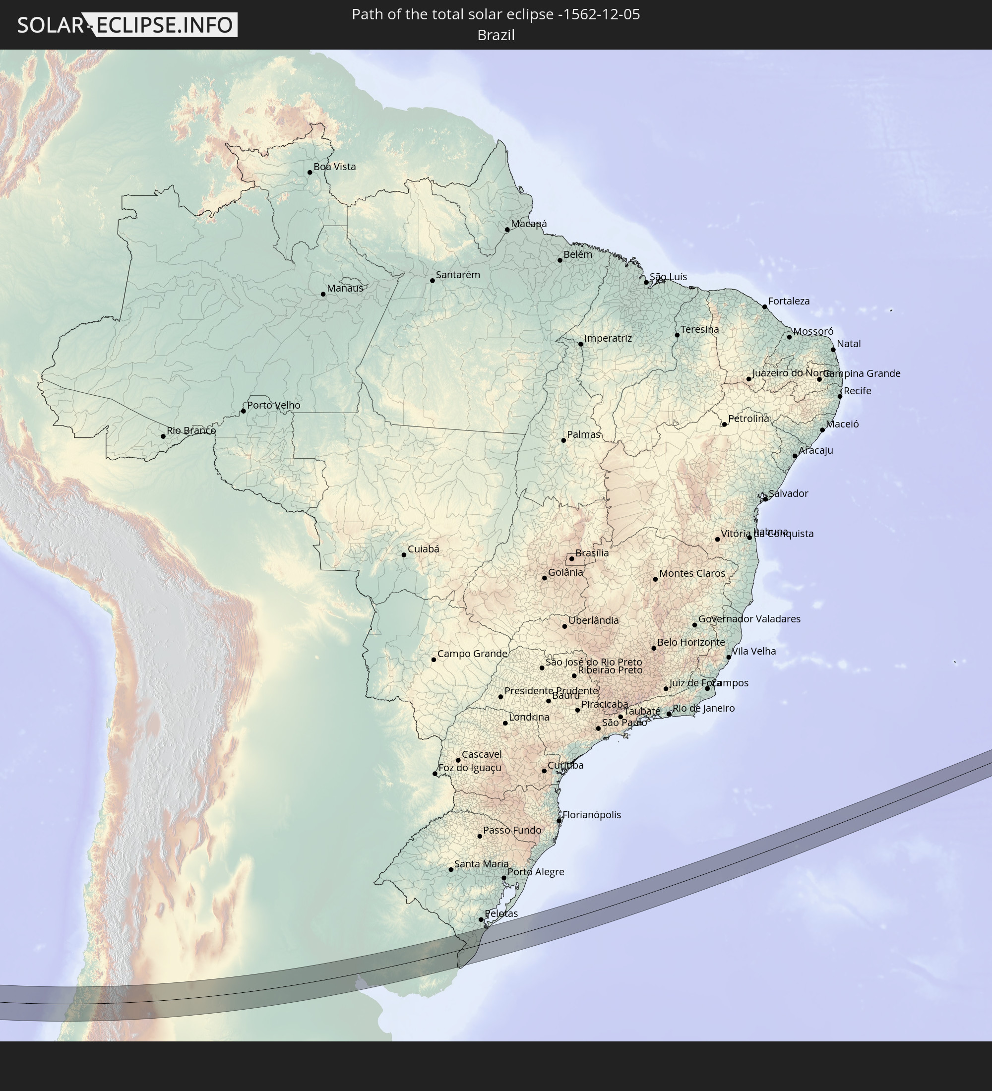 Brazil
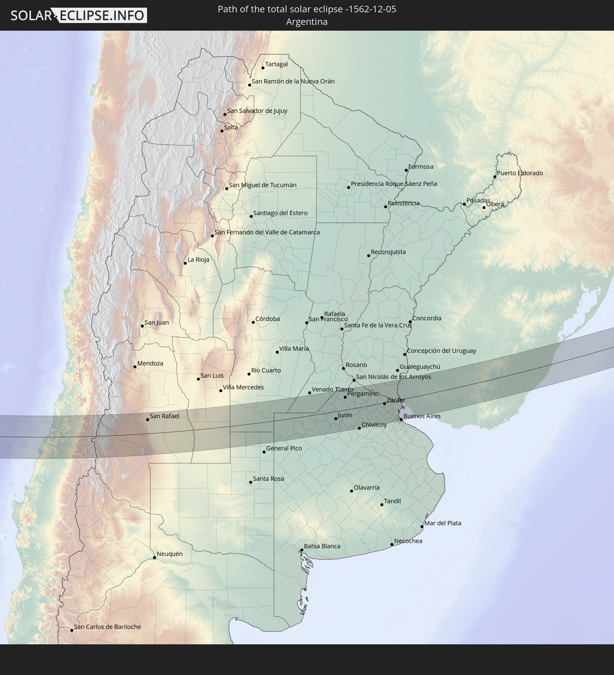 Argentina
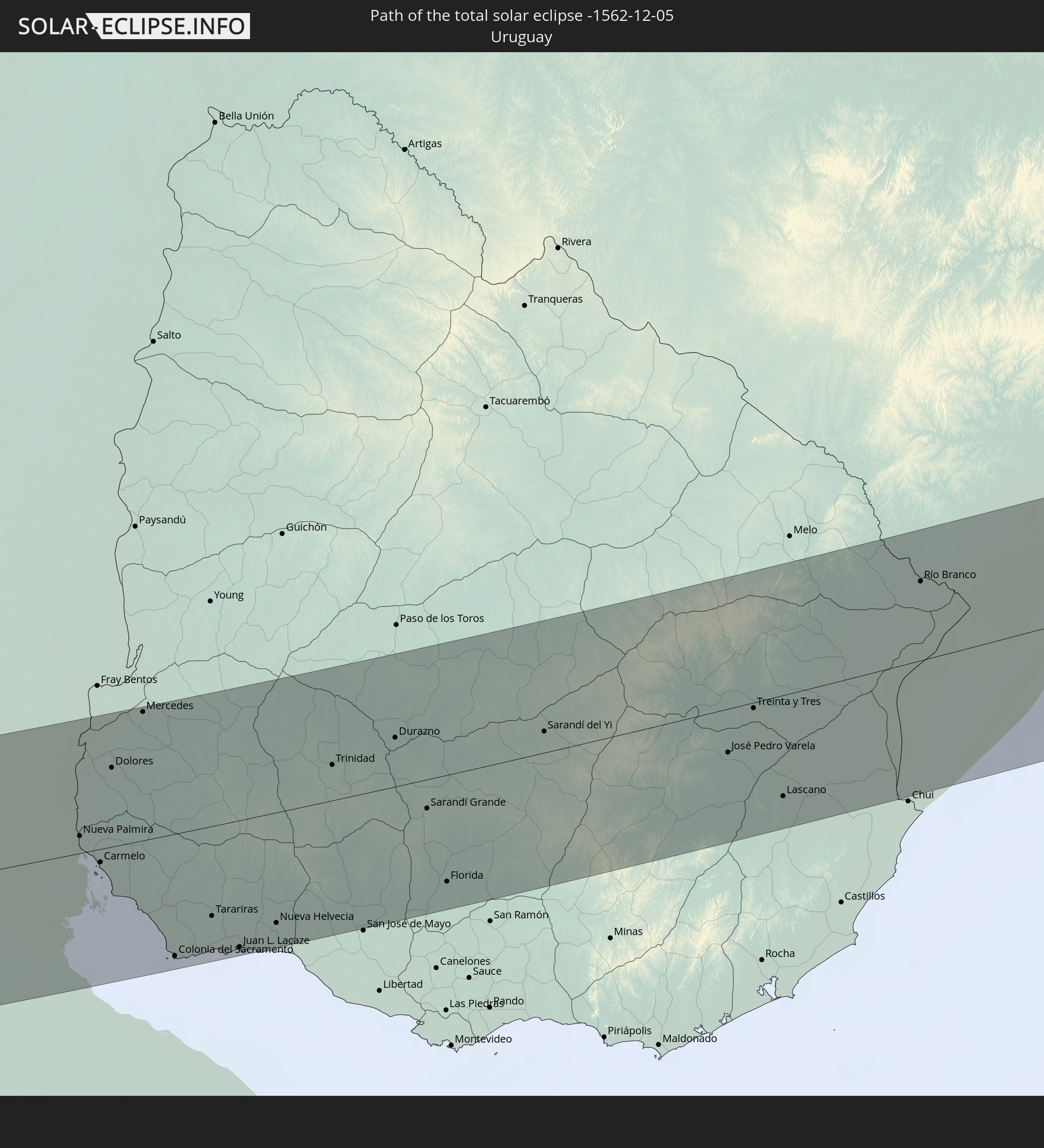 Uruguay
In den folgenden Ländern ist die Sonnenfinsternis partiell zu sehen


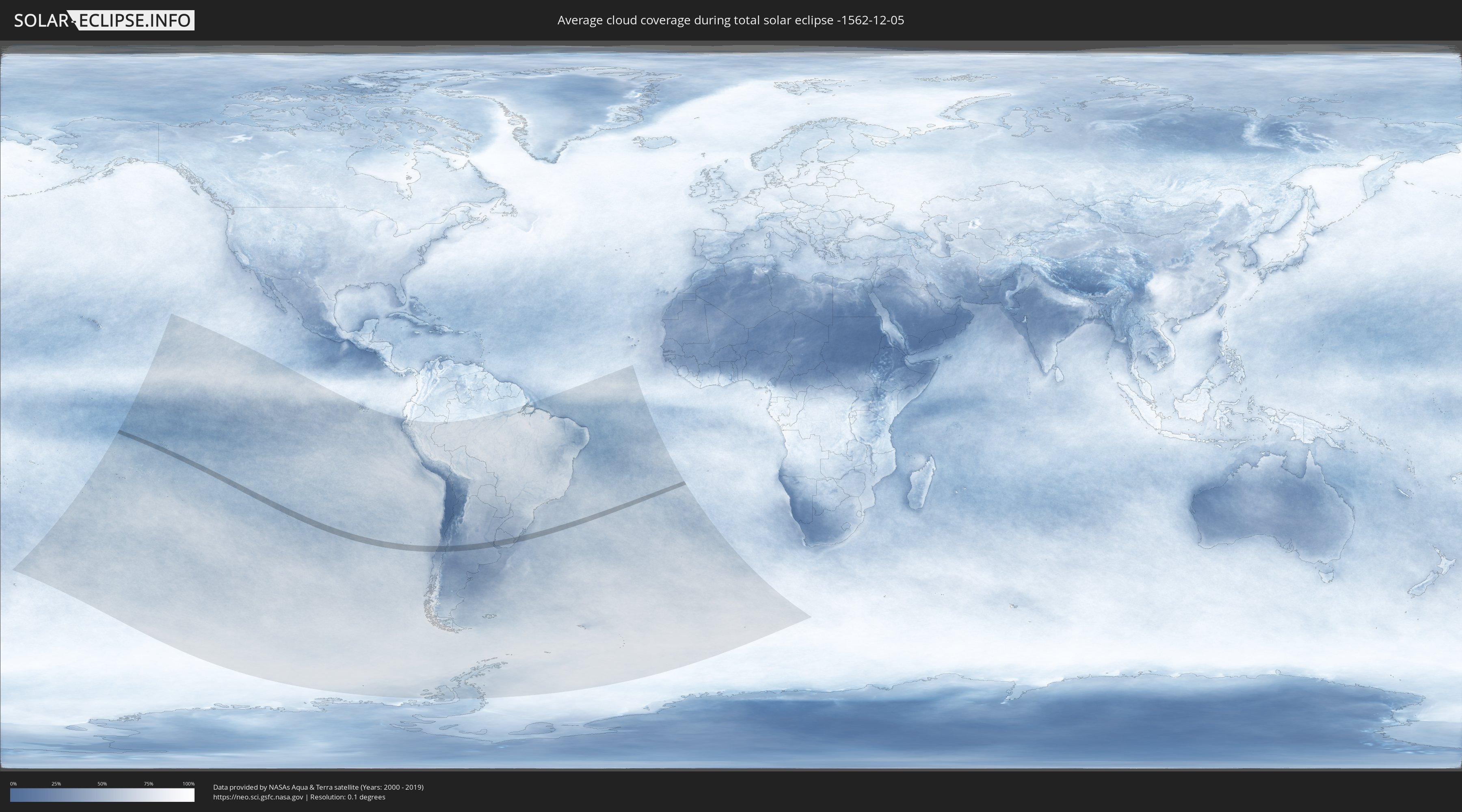
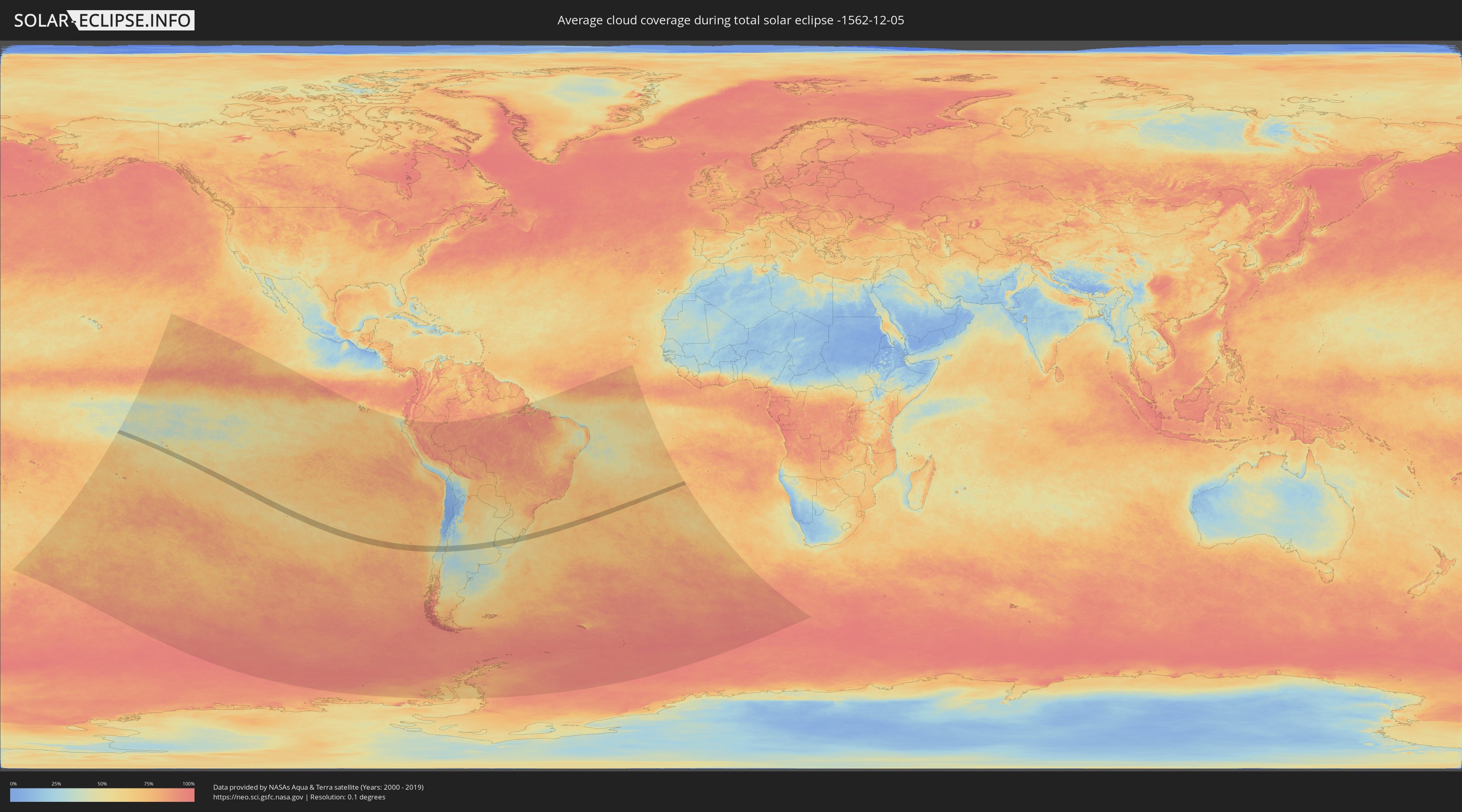
How will be the weather during the total solar eclipse on 12/05/-1562?
Where is the best place to see the total solar eclipse of 12/05/-1562?
The following maps show the average cloud coverage for the day of the total solar eclipse.
With the help of these maps, it is possible to find the place along the eclipse path, which has the best
chance of a cloudless sky.
Nevertheless, you should consider local circumstances and inform about the weather of your chosen
observation site.
The data is provided by NASAs satellites
AQUA and TERRA.
The cloud maps are averaged over a period of 19 years (2000 - 2019).
Detailed country maps
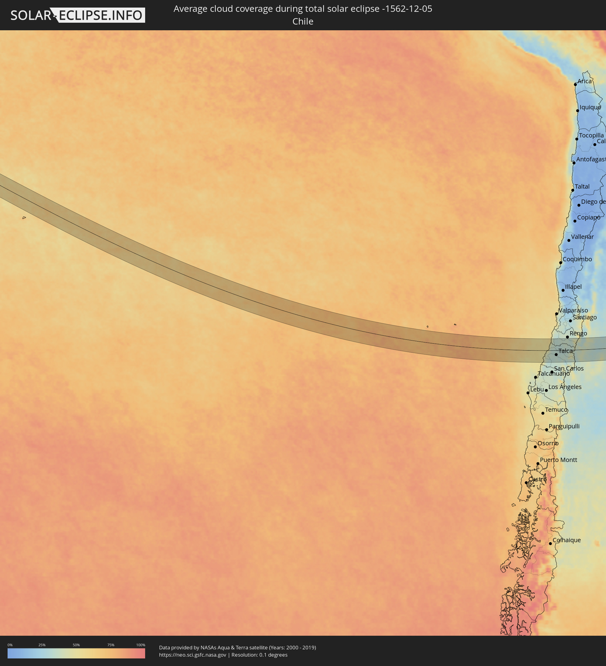 Chile
Chile
 Brazil
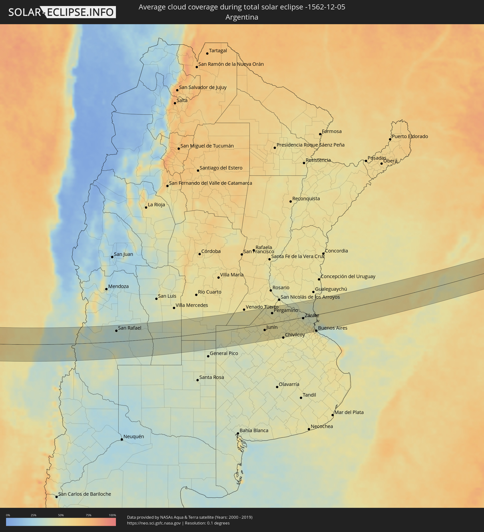 Argentina
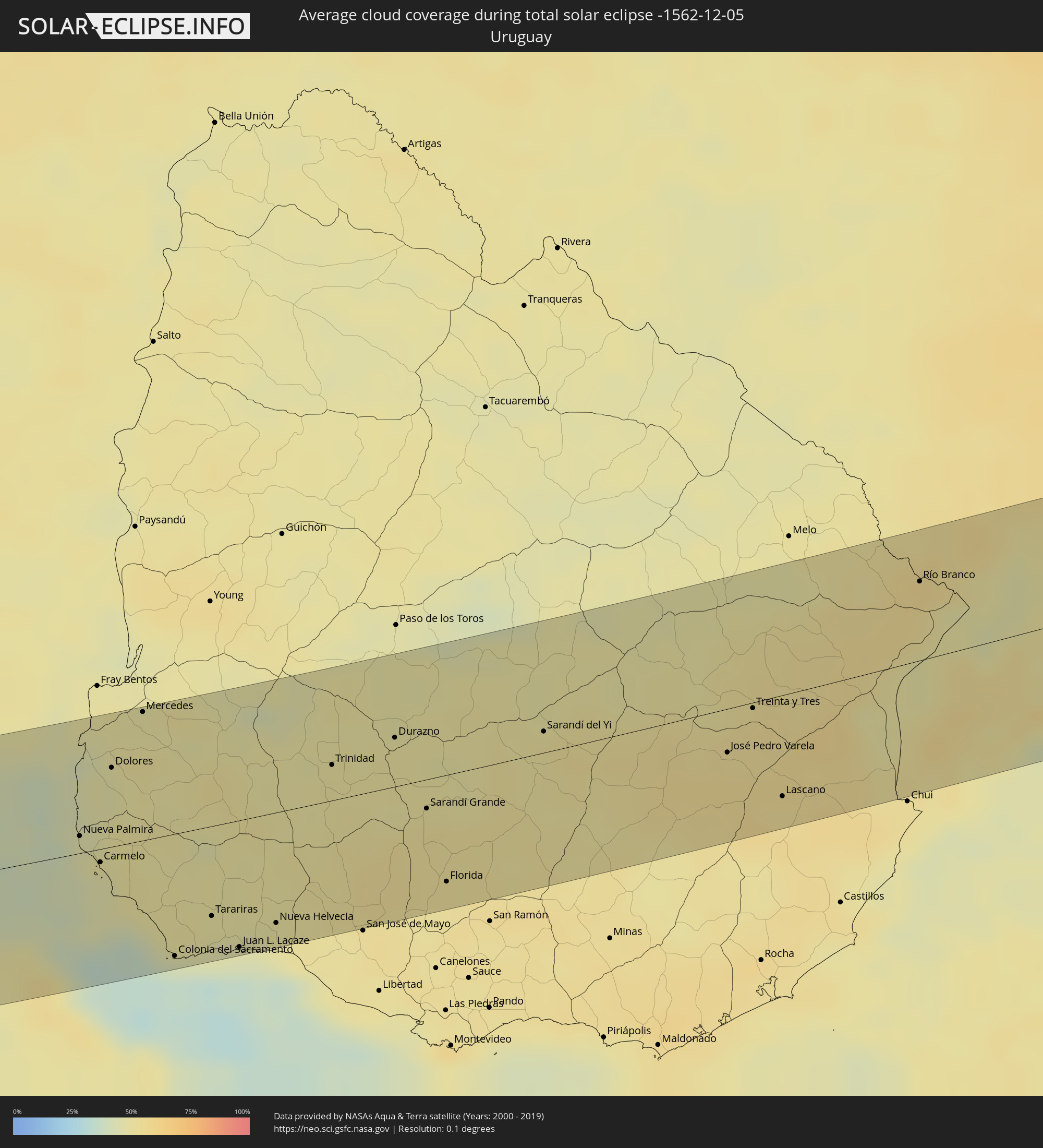 Uruguay
Cities inside the path of the eclipse
The following table shows all locations with a population of more than 5,000 inside the eclipse path. Cities which have more than 100,000 inhabitants are marked bold. A click at the locations opens a detailed map.
| City | Type | Eclipse duration | Local time of max. eclipse | Distance to central line | Ø Cloud coverage |
 Constitución, Maule
|
total | - | 13:16:36 UTC-04:42 | 19 km | 45% |
|
San Javier, Maule
|
total | - | 13:18:00 UTC-04:42 | 48 km | 34% |
|
Talca, Maule
|
total | - | 13:18:12 UTC-04:42 | 30 km | 33% |
|
San Clemente, Maule
|
total | - | 13:18:32 UTC-04:42 | 42 km | 32% |
|
Santa Cruz, O'Higgins
|
total | - | 13:19:01 UTC-04:42 | 58 km | 34% |
|
Rauco, Maule
|
total | - | 13:19:03 UTC-04:42 | 26 km | 32% |
|
Molina, Maule
|
total | - | 13:19:04 UTC-04:42 | 5 km | 32% |
|
Curicó, Maule
|
total | - | 13:19:12 UTC-04:42 | 19 km | 34% |
|
Teno, Maule
|
total | - | 13:19:23 UTC-04:42 | 32 km | 33% |
|
Chimbarongo, O'Higgins
|
total | - | 13:19:41 UTC-04:42 | 49 km | 37% |
 San Rafael, Mendoza Province
|
total | - | 13:51:24 UTC-04:16 | 48 km | 33% |
|
Villa Huidobro, Cordoba Province
|
total | - | 13:58:43 UTC-04:16 | 7 km | 45% |
|
Huinca Renancó, Cordoba Province
|
total | - | 13:59:07 UTC-04:16 | 10 km | 42% |
|
Realicó, La Pampa Province
|
total | - | 13:59:15 UTC-04:16 | 33 km | 42% |
|
Intendente Alvear, La Pampa Province
|
total | - | 14:00:20 UTC-04:16 | 62 km | 39% |
|
Laboulaye, Cordoba Province
|
total | - | 14:01:24 UTC-04:16 | 57 km | 47% |
|
Rufino, Santa Fe Province
|
total | - | 14:02:34 UTC-04:16 | 33 km | 45% |
|
Villa Cañás, Santa Fe Province
|
total | - | 14:04:46 UTC-04:16 | 47 km | 48% |
|
Lincoln, Buenos Aires
|
total | - | 14:04:18 UTC-04:16 | 49 km | 47% |
|
Junín, Buenos Aires
|
total | - | 14:05:32 UTC-04:16 | 27 km | 50% |
|
Pergamino, Buenos Aires
|
total | - | 14:06:41 UTC-04:16 | 44 km | 48% |
|
Chacabuco, Buenos Aires
|
total | - | 14:06:18 UTC-04:16 | 40 km | 51% |
|
Mercedes, Buenos Aires
|
total | - | 14:08:04 UTC-04:16 | 58 km | 47% |
|
Luján, Buenos Aires
|
total | - | 14:08:41 UTC-04:16 | 55 km | 49% |
|
Zárate, Buenos Aires
|
total | - | 14:09:10 UTC-04:16 | 5 km | 45% |
|
Campana, Buenos Aires
|
total | - | 14:09:14 UTC-04:16 | 14 km | 47% |
|
Morón, Buenos Aires
|
total | - | 14:09:25 UTC-04:16 | 72 km | 50% |
|
Tigre, Buenos Aires
|
total | - | 14:09:40 UTC-04:16 | 48 km | 48% |
|
San Isidro, Buenos Aires
|
total | - | 14:09:43 UTC-04:16 | 54 km | 51% |
|
Villa Santa Rita, Buenos Aires F.D.
|
total | - | 14:09:40 UTC-04:16 | 70 km | 54% |
|
Colegiales, Buenos Aires F.D.
|
total | - | 14:09:45 UTC-04:16 | 67 km | 52% |
 Nueva Palmira, Colonia
|
total | - | 14:42:20 UTC-03:44 | 9 km | 44% |
|
Retiro, Buenos Aires F.D.
|
total | - | 14:09:51 UTC-04:16 | 69 km | 52% |
|
Buenos Aires, Buenos Aires F.D.
|
total | - | 14:09:51 UTC-04:16 | 72 km | 52% |
|
Carmelo, Colonia
|
total | - | 14:42:26 UTC-03:44 | 7 km | 45% |
|
Dolores, Soriano
|
total | - | 14:42:55 UTC-03:44 | 43 km | 47% |
|
Mercedes, Soriano
|
total | - | 14:43:27 UTC-03:44 | 70 km | 49% |
|
Colonia del Sacramento, Colonia
|
total | - | 14:42:47 UTC-03:44 | 66 km | 35% |
|
Tarariras, Colonia
|
total | - | 14:43:18 UTC-03:44 | 48 km | 47% |
|
Juan L. Lacaze, Colonia
|
total | - | 14:43:26 UTC-03:44 | 68 km | 42% |
|
Rosario, Colonia
|
total | - | 14:43:41 UTC-03:44 | 59 km | 45% |
|
Nueva Helvecia, Colonia
|
total | - | 14:43:53 UTC-03:44 | 60 km | 49% |
|
Trinidad, Flores
|
total | - | 14:45:04 UTC-03:44 | 19 km | 50% |
|
Trinidad, Flores
|
total | - | 14:45:03 UTC-03:44 | 17 km | 50% |
|
Durazno, Durazno
|
total | - | 14:45:46 UTC-03:44 | 26 km | 49% |
|
Sarandí Grande, Florida
|
total | - | 14:45:46 UTC-03:44 | 16 km | 53% |
|
Florida, Florida
|
total | - | 14:45:38 UTC-03:44 | 57 km | 52% |
|
Sarandí del Yi, Durazno
|
total | - | 14:47:10 UTC-03:44 | 11 km | 51% |
|
José Pedro Varela, Lavalleja
|
total | - | 14:48:43 UTC-03:44 | 24 km | 55% |
|
Treinta y Tres, Treinta y Tres
|
total | - | 14:49:08 UTC-03:44 | 3 km | 54% |
|
Lascano, Rocha
|
total | - | 14:49:00 UTC-03:44 | 54 km | 55% |
|
Río Branco, Cerro Largo
|
total | - | 14:51:09 UTC-03:44 | 43 km | 55% |
 Jaguarão, Rio Grande do Sul
|
total | - | 15:29:34 UTC-03:06 | 46 km | 55% |
|
Santa Vitória do Palmar, Rio Grande do Sul
|
total | - | 15:28:43 UTC-03:06 | 57 km | 53% |